 "
]
},
{
"cell_type": "markdown",
"metadata": {},
"source": [
"
"
]
},
{
"cell_type": "markdown",
"metadata": {},
"source": [
"This analysis will focus on two neighboring regions in the state of Northrine-Westphalia (NRW) in the West of Germany with very different tectonic settings. The first region considered is the Lower Rhine Graben (German: Niederrheinische Bucht), which consists roughly of the region bounded by the towns of Bonn, Köln (Cologne), Aachen, Düsseldorf (Dusseldorf), Bocholt and the Dutch border. The tectonic setting of the Lower Rhine Graben continues into parts of the Netherlands (cf. e.g. Klostermann et al. 1998).
\n", "The Lower Rhine Graben is part of the European Cenozoic Rift System that consists of different graben structures in France, Germany, the Netherlands and Czech Republic (cf. e.g. Schwarz 2005). The European continent is located inside a stress field dominated by the northbound movement of the African plate and the spreading of the Atlantic ocean, which causes a movement of the European plate in the opposite direction (Grünthal 2004, Schneider 2013). These large scale plate movements lead e.g. to the formation of the Alps, but also to strain in the middle of the European continent. This strain causes graben formation in Europe. Within those grabens, a major Northwest-Southeast stress field (Ahorner, Murawski and Schneider 1972) leads to further fragmentation and the formation of a fault system that is also typical for the Lower Rhine Graben (cf. e.g. Ahorner 1962, where also a map of the fault system can be found).
\n", "The Lower Rhine Graben is a seismicly active region. In general, despite mining activities (open-pit mines) in the Lower Rhine Graben, most earthquakes in this region can be directly linked to faults (Ahorner, Murawski and Schneider 1970). Most recent earthquakes were the $M_L=5.9$ earthquake near the town of Roermond (Netherlands) that caused damage worth 150 million Deutsche Mark (approximately 90 million USD) in the German part of the Lower Rhine Graben on April 13, 1992 (Meidow 1995, GD NRW: https://www.gd.nrw.de/zip/gg_erdbeben-roermond.pdf) and the $M_L=4.8$ earthquake near Alsdorf (Germany) on July 22, 2002 (GD NRW: https://www.gd.nrw.de/zip/gg_erdbeben-alsdorf.pdf), which will be analyzed in this code. Even stronger was the earthquake near the city of Düren in 1756 with a reconstructed magnitude of $M_L=6.1$ that was felt in towns as far as Paris and Halle (Meidow 1995). More recent palaeseismologic studies even lead to the conclusion that earthquakes with magnitudes of up to $M_L=7.0$ have occured in prehistoric times and are still possible in the Lower Rhine Graben (Skupin et al. 2008, Pelzing 2008). Since the West of NRW is one of the most densely populated regions in Germany, a good knowledge of the tectonic setting is vital.
" ] }, { "cell_type": "markdown", "metadata": {}, "source": [ "In contrast to this, the neighboring Ruhr area (German: Ruhrgebiet) is not part of any large-scale tectonic system. Old thrust and normal faults as well as fold structures can be found, but those structures are dormant and no tectonic earthquakes occur in the Ruhr area (Bischoff et al. 2010). However, about 1000 earthquakes with a magnitude range of $0.7\\leq M_L \\leq 3.3$ are registered every year (Bischoff et al. 2010). The strongest recorded event, a magnitude $M_L=3.3$ earthquake near the town of Moers on December 12, 2007, will be studied in the following code.
\n", "All earthquakes in the Ruhr area are temporally and spatially correlated with mining activities (Bischoff et al. 2010). Typical locations are fractures parallel to longwalls, but focal mechanisms linked to failure of remnant pillars or reactivation of older faults have been found as well (Alber et al. 2009, Bischoff et al. 2020). The spatial correlation between earthquakes and mining activities will be investigated in this code. The Ruhr area, consisting of the towns of Duisburg, Essen, Bochum, Dortmund, Hamm and their surroundings (see map below), used to be the largest coal mining area in Germany. Mining activities started in this area in the 13th century. Modern mines were located at a depth between 700 and 1500 meters below the ground and used the longwall mining technique (Bischoff et al. 2010). The last coal mine in the Ruhr area was closed in 2018 ( https://www.rag.de/news/t2_news/eine-aera-geht-zu-ende-deutschland-nimmt-abschied-vom-heimischen-steinkohlenbergbau/ ).
\n", "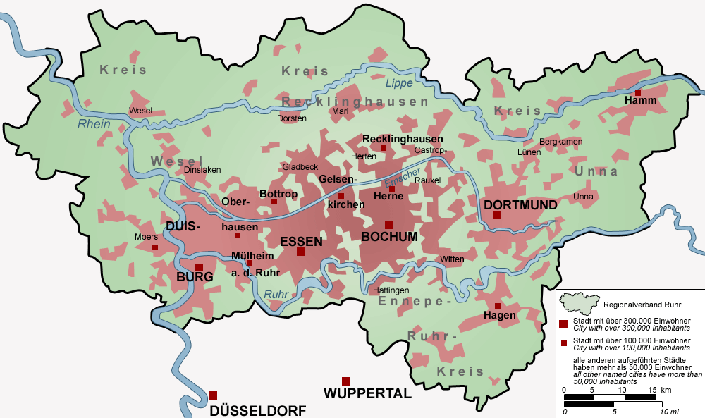 "
]
},
{
"cell_type": "markdown",
"metadata": {},
"source": [
"The following analysis will be divided into two parts: In the first part, seismic signals from the human induced Moers earthquake in the Ruhr area and the tectonic Alsdorf earthquake in the Lower Rhine Graben will be compared to each other and to the seismic signal from the detonation of a bomb from World War II ($M_L=1.3$) that was found during a construction project in Essen on March 30, 2020 ( https://www.essen.de/meldungen/pressemeldung_1371810.de.html , http://www.seismo.uni-koeln.de/catalog/2020.htm ). In the second part, the analysis will focus on the Ruhr area. It will be shown that most earthquakes occur close to operating mines."
]
},
{
"cell_type": "markdown",
"metadata": {},
"source": [
" Part I - Comparison of seismic signals from different events in Northrhine-Westphalia "
]
},
{
"cell_type": "markdown",
"metadata": {},
"source": [
"Import all Python libraries needed:"
]
},
{
"cell_type": "code",
"execution_count": 1,
"metadata": {},
"outputs": [],
"source": [
"import matplotlib.pyplot as plt\n",
"import geopandas\n",
"import contextily as ctx\n",
"import pandas as pd\n",
"import numpy as np\n",
"from shapely.geometry import Point\n",
"from random import randrange\n",
"from obspy import UTCDateTime\n",
"from obspy.clients.fdsn import Client"
]
},
{
"cell_type": "markdown",
"metadata": {},
"source": [
"For the following analysis, the client of the German Bundesamt für Geowissenschaften und Rohstoffe (BGR) will be used ( https://eida.bgr.de/ ). For all three events analyzed, data from the station BUG in Bochum of the German network GR wil be used. This station is the closest with open-access data to the event with the smallest magnitude considered in this analysis (the bomb detonation in Essen) and is therefore chosen. Data for all three orientations (Vertical, North-South, East-West) of the broadband, high-gain (BH*) channel of the station will be requested."
]
},
{
"cell_type": "markdown",
"metadata": {},
"source": [
"The analysis will start with requesting data for the December 12, 2007 earthquake near Moers (Ruhr area). Seismograms for all three orientations will be plotted."
]
},
{
"cell_type": "code",
"execution_count": 2,
"metadata": {},
"outputs": [],
"source": [
"client = Client(\"BGR\")\n",
"startt = UTCDateTime(\"2007-12-12T14:52:30\")\n",
"endt = startt + 120 \n",
"station = \"BUG\"\n",
"channel = \"BH*\"\n",
"network = \"GR\"\n",
"location = \"\"\n",
"st_ruhr = client.get_waveforms(network, station, location, channel, startt, endt)\n",
"st_ruhr = st_ruhr.trim(startt, endt)"
]
},
{
"cell_type": "code",
"execution_count": 3,
"metadata": {},
"outputs": [
{
"data": {
"image/png": "iVBORw0KGgoAAAANSUhEUgAAAvQAAADtCAYAAADQmuFsAAAABHNCSVQICAgIfAhkiAAAAAlwSFlzAAAPYQAAD2EBqD+naQAAADh0RVh0U29mdHdhcmUAbWF0cGxvdGxpYiB2ZXJzaW9uMy4xLjEsIGh0dHA6Ly9tYXRwbG90bGliLm9yZy8QZhcZAAAgAElEQVR4nOydd3gUVRfG35tCSIBAAoHQQw+9C1E+qgqCIE1BiqAUaQoiTQEBQVBBRLpIUwFRaQKCICKg9CYl9BICBBKSENKTTfZ8f8zeYWZ3drMJkRA8v+eZJzu33zuT3feeOfeOICIwDMMwDMMwDJM7ccnpBjAMwzAMwzAMk3VY0DMMwzAMwzBMLoYFPcMwDMMwDMPkYljQMwzDMAzDMEwuhgU9wzAMwzAMw+RiWNAzDMMwDMMwTC6GBT3DMAzDMAzD5GJY0DMMwzAMwzBMLoYFPcMwDMMwDMPkYljQMwzDMAzDMEwuhgU9w+QgQggPIcQKIcQtIcQDIcQeIURNqzTjhBD3hBDRQojPhRBCE9dQCHFKCJEohNgrhCiriQsWQsRrDrMQ4n077XATQqwXQtwWQpAQwt8qfrYQ4poQIk4IcUwI0dRBn7JUlhDiQ01bU4QQJs35YiFEMSHEVstYJDuoP8jS13EO0vQVQqRZjU8ZS1wVSz2RlrpWCSF8HJQ1RQhxUwgRK4S4LIR406CuW5b4FUKIPA7a/acQ4r4Q4o4QYr5RWqP+OepPdiKEeFkIcdByr94SQkyyiq8ghNhvuR9PCCFqa+JchBBzhBAxQohwIcR7mrieVm1PFkLEOWhHVyHEYct9stgqzqlxfNSyrNpLQogE7dgLIYYIIf6xXBdH9+Jvju5nS5oQy5iq/w8GaQoKIe4KIX5zUI7DsRFC1BFCHLD8b54UQtR1UFaAEGKH5V64KIR4QRPnIoSYLpTvgGghxCwhdN9bGfaHYZjMwYKeYXIWNwDXADQG4AtgM4BNMlII0RbAYACNAFQH8DKANy1xHgA2APjKkvcQgO9lXiKqTkT5iSg/gLIATAB+cdCWfQC62Il7AOBFAAUBfAZgkxCiQHaWRUTTNe2dBGC1PCeiQQDMALYCeMtepUIIFwBfAjjqoG2SXZry8xNRqCW8IICfAFQAEAAgD4BZDspZBSCQiLwBtAXwiRCiuqU9NQHMBtARQGlLeRPslFMQyrUsBaAGgFoAxmaif/b6k50UgNL+ogCeBdBdCNFbE/8DgJ1Q7sflADYKIdwscYMANAVQ2fJ3jBCiJQAQkfZa5wewEMBGB+2IBvA5gKUGcRmOY3aUZdXeFADVrcY+DMpYbbZXsRCiI4D8DtqmpaXV/4M1UwBcyaAMu/0RQrhDGfOVAAoB+BTK9bM3GVoN5T4sDGAAgLVCiCKWuH4A2gGoB6AilHtlYCb7wzBMZiAiPvjg4wk5oIhHM4DClvMfAIzVxL8FYLflc2sA5zVx+QAkAihrUO5gAAedbAMB8M8gzW0A9f+tsgCMA7DSTvoAAMl24gZBESwrAYxzUGdfAL85OR4vADjjZNpKAO4CaGs5nwFgkSa+JYBrTpY1AMAWZ/qXmf5k8/36CYB5ls9VoEzW8mjibwBoavl8EEA3TdzHAJYblOkCRQy3dqL+yQAWZ3Ycs7ssAMkAAuzkMbwXAeQFcBZAE3v3syZtCIDGDuJrADhi+X5w+j7Q9gdATQDhVvEXAbxgkK8AlO8pL03YDgADLJ/XAxisiXsdwH5n+8MHH3xk/mALPcM8WQRB+VGNspxXA3BGE38KiqXeJo6IEgBctYRb0xOKRe2REUIEQLHAZmQNfNxl+QIYAUWYWcc1EULEWAU/J4SIEkKcE0I4shA+CyBYU9Y4IcRWq/LHCSESAFyCImJ3W6KMrl85IYSnE12yrtdu/zLZn+xE28ZqAC4SUaom/jTs3K/Q38taWgJwBbDrX2jjk1TWOABrAdyyjhCKy5e1m84mi6vSRqFxrbMwF8D7UES2dVkxQogmdtqQUX8EjK+RNt5eWkdxgOP+MAyTSdwyTsIwzONACFEQwNcAxmuC8wOI1ZzH4uEjeus463hZbgCAZwB0zoY2ugP4FsBMInrwpJRlYTqAOUR0X+OuCwAgor+huBFI9kKxSIYCaAjFtSCciHRuHkKIOgDeheIiIsv61LpiIvpUCPEZlHF+HkCaJcro+snwJHsdEUK8BOAlALU1wXb752x/shMhxNsAikO5hkDG96Oje1lLTwBriSg9G9poNI5PQlkBAF6D4pLibx1PRC9bBfUAcALKE7ypUMRwPSIiIUR3ABFE9JcQooJBWYWswyxtsO7PRQDJlsngMgBdobjLeBmUGSeEOAzgQyHEFCgTg2ZQLO+A4nY1RAixEYqr31Crcuz2x6itDMNkDFvoGeYJQAiRF4rv/K9EtFwTFQ/AW3PubQkzirOOl/SA4l8doalPu2DWqcWTlkVtKwFEQGMlzs6ysopl8d4zAL5xJj0RXSeiECIyE9FhKBbOTlZllgOwBUA/IsrQKksKh6GI3H6WYKPrJ8Pt9aUhgBUAOhJRuDP9c6Y/durSLkZ1emGiEOJlAB8BeJmI5MQko/vR0b0sy80LZeK5WhOW1TYajWO2lfWIfAlgIhE5XAwrIaIDRJRMRLEARkJx7SonhMgHxXd+dGYqN+qP5clKJwC9obiNdYTylOS2nWJ6AmiAh2sF1mnSLgWwHYob0FEA27Tl2OtPZvrAMIwettAzTA5jWTS4FsoP4yir6HNQLK/bLOe18fAR+TloFppZftwrWMK19IDiy61CRI4eo9tjHoASANoQkfpoPzvLegSaQVlsedtivS4IIE0IUYGIBjiRX9cGoezM8zuAqUS0yTiLXVygXAfg4fWT1AZwXSOCdQghqkJZRPkWER3SRGW2f06NKRGtRiZdsYSyK9EyKOsEtK5S5wBUEUK4E5HJElYLwExNfE08vD+197KkPRRr85FHbKPhOGZnWY9IcwBBQogFUNyLPIQQdwE0I6KLGeQlywE8FMJHLfeFJ4C8Qohge/+XjvpDRCcAPGdJ5wrFhe+4YSOIrkFZxyPL/RvAGktcOhSXonGWuP4AjjnRH4ZhskpOO/Hzwcd//YBiKdsBwN0grh2Ux9jloDyaPwvlhxgAPADchLIg0gOKaN9nlb8OFCtoPifa4QFloR5B2RUnryZuCoCTALyd7NMjlQU7i2ItZVaBsggxLwAPS7iXZXzk8SOAaQAK2Sm/DQA/y+d6UPyYX7OcF4Ti3/2Rk33tD8WdxwWK8H6Ah4tiawKIstRREMAfAD62U05pKC4zfQziHPbPUX+y+V6tA+WpyvN24o8AmGi5/kOg7ODkZokbCkXU+UGZnIQBaGWVfxOAyU60w9Vy/adBeWqRV1OP3XH8t8qCwaJYKAazvFB2nppg+exqiSuquZYNLfn9Zb1W5ZSBsrbGHcrC9y+gfA+4WOrQ3hfDoazfKJrZe0xzv3pAWfQ6E8AmB32uammPp6XekwCEJa4wlMXrAooV/zosC98d9Se771c++PgvHTneAD74+C8fUMQuQfGnjtcc/9Ok+QBAJID7ULbXE5q4hlAWHiZB2SqyrFX5M6Fs/+hMW0Lw0FpGULxIZBxZRIe2jT3/rbJgX9CT1RFip/6V0O8C8z8A8ZrzL6AI03govsPvaOL6WMrWtk+b90MA2zXnG6CI9jgoFueBVm3pC8XdIM7SLg9NXLDsO5StOs1W9QY72T+7/cnm+3UFgHSrNmrHoiKA/Zb78SSAOpo4FwBzAMRY2jrSqmwfKNs/VnKiHX0N7oXJmR3H7CoLxoJ+skG5fQ3yBsBqlxso7iofWj5Xh7KYOAHAPShbz1Zw0JffrMLU75OM+gPFFSgGyqT0e2gmxFBcbLRpR+Hhfb8FQGlNXFUoC90TAVwA0FkT53R/+OCDD+cPOZtmGIZhGIZhGCYXwotiGYZhGIZhGCYXw4KeYRiGYRiGYXIxLOgZhmEYhmEYJhfDgp5hGIZhGIZhcjEs6BmGYRiGYRgmF8OCnmEYhmEYhmFyMSzoGYZhGIZhGCYXw4KeYRiGYRiGYXIxLOgZhmEYhmEYJhfDgp5hGIZhGIZhcjEs6BmGYRiGYRgmF8OCnmEYhmEYhmFyMSzoGYZhGIZhGCYXw4KeYRiGYRiGYXIxLOgZhmEYhmEYJhfDgp5hGIZhGIZhcjEs6BmGYRiGYRgmF8OCnmEYhmEYhmFyMSzoGYZhGIZhGCYXw4KeYRiGYRiGYXIxLOgZhmEYhmEYJhfDgp5hGIZhGIZhcjEs6BmGYRiGYRgmF8OCnmEYhmEYhmFyMSzoGYZhGIZhGCYXw4KeYRiGYRiGYXIxLOgZhmEYhmEYJhfDgp5hGIZhGIZhcjEs6BmGYRiGYRgmF8OCnmEYhmEYhmFyMSzoGYZhGIZhGCYXw4KeYRiGYRiGYXIxbjndgCcBIYQAUAJAXE63hWEYhmEYhmEsFAAQRkTkKBELeoUSAG7ldCMYhmEYhmEYxopSAG47SsCCXiEOAG7evAlvb++cbgvDMAzDMAzzHyc2NhalS5cGnPAgYUGvwdvbmwU9wzAMwzAMk6tgQZ9Frl+/jvPnz8NkMuV0U3Il7u7uCAwMRPny5XO6KQzDMAzDMLkaFvSZJDY2FiNHjsQ///yT0015KqhVqxbmzJnDT0YYhmEYhmGyCAv6TDJlyhRcu3YNn3/+OYKCguDp6ZnTTcqVJCcn49ChQ5g2bRo++ugjzJkzJ6ebxDAMwzAMkyvhfegzQWxsLP7++28MGjQILVu2ZDH/COTNmxfNmzfHkCFDcODAAcTExGSYZ+HChQgPD38MrWMYhmEYhsk9sKDPBLdu3UJ6ejpq1aqV0015aqhVqxbMZjNu3rzpMJ3JZMLQoUPxxhtvPKaWMQzDMAzD5A5Y0GeC9PR0AMqCTiZ7kGOZlpbmMJ18n0JcHL/7i2EYhmEYRgsL+mxk2bJlqF27Nry8vFCiRAm0bt0au3btAgAIIZAvXz7kz58fZcuWxYwZM+yWExISAiEE8ufPj/z586NkyZKYMmWKGr9nzx4EBgba5AsMDMSePXvU87/++gutWrVCgQIFUKRIETRs2BCLFy92qi979uyBi4uL2oZy5cphyZIlGbYhb968CAkJQWhoqJpXewgh8PHHHzvVBi1S0MtJlbOEhoY6HGuGYRiGYZjcDgv6bGLq1KmYNGkSZsyYgaioKNy4cQOjRo3Cjh071DRXr15FfHw8NmzYgGnTpuH333+3W56Hhwfi4+MRHx+Pv//+G9988w127tzpdHv+/PNPvPTSS+jYsSNu3LiByMhILFu2DPv27XO6jMqVK6tt2LBhA0aNGoULFy44lbdMmTJqXnmsXLkSfn5+6Nevn9NtkEhBn5El35pevXrhww8/zHQ+hmEYhmGY3AIL+mzg/v37mD59OhYtWoS2bdvC09MT7u7ueOGFFzBz5kyb9PXr10f16tWd3vqyXLlyePbZZ3H+/Hmn2/TBBx/g7bffxjvvvANfX18Air/6mjVrnC5DS926dREYGIiLFy9mKf/169cxcOBArFy5EiVLlnQ634MHDzB58mSYzWYAmbfQp6amAoCan2EYhmEY5mmDBX02cOjQIaSlpaFt27ZOpT969CiCg4OdfqnS1atXceDAATzzzDNOpU9ISMCRI0fQoUMHp9I7w/Hjx3HlyhXUqVMn03lNJhO6d++O/v37Oz1Gko8//hhTpkzBsWPHAGTeQp/ViQDDMAzDMExugfehzwaioqJQpEgRuLq6qmH+/v5ISkqCEELdkrFKlSowmUxISkrCkCFD0KlTJ7tlpqSkoFChQjCbzYiLi0O3bt2cFvT3798HEcHf318N69q1K3bt2oWUlBTs3bvXqbIuX76MQoUKIT09HfHx8Rg9ejTKli1rE2/dbmvGjRsHIQQ++eQTp9qvRQr4rArzrPreMwzDMAzD5BbYQp8NFC5cGJGRkTrRePfuXZw6dQrJyclq2MWLFxEfH4/58+dj//79MJlMdsv08PBATEwMYmNjce/ePURGRmLMmDEAADc3N8O8JpMJ7u7u8PHxgRACd+/eVePWrVuHmJgYFCtWzGn3k0qVKiEmJgZxcXEIDQ3Fb7/9hnnz5tnEaw8PDw9dGVu3bsWKFSuwdu3aLO0OJIQA8FDQZ9ZCz4KeYRiGYZinHRb02UDjxo3h5uaGbdu2ZZjWxcUFQ4cOReHChbFw4UKnyi9SpAg6deqkLrAtXbo07ty5o/qHA4pl/M6dOyhTpgzy5cuHZ555Bps3b85ahwwoXbo0WrdurVvkmxG3bt3Cm2++iaVLlyIgIOCR6s+qhZ5dbhiGYRiGedphQZ8N+Pj44MMPP8TgwYOxbds2JCUlIS0tDUeOHLGbZ/To0Zg1a5ZOlNsjJiYGv/zyC6pWrQoAKFu2LGrVqoVJkyYhMTERiYmJmDhxIurUqYPSpUsDAGbMmIGvv/4a8+bNU11wgoODs7yP+507d7Bz5061DRmRnp6OHj16oHv37ujcuXOW6gRsLfRPk8tNamoqIiMjc7oZDMMwDMPkcljQZxMTJ07E5MmT8cEHH6Bw4cIoU6YMli1bhq1btxqmb9OmDXx8fPDdd98BAF566SVMnz5djU9JSVH3bq9QoQIKFCiAuXPnqvE//fQTLly4gICAAAQEBODKlSv48ccf1fgWLVpg27Zt2LhxI8qUKQM/Pz/07dsXn376KRo0aAAAGDRoEAYNGqTmqV69OlavXq2eX7p0SW1D7dq1Ub9+fUyaNMmp8di/fz/++usvLFu2zGYvem2dGfGoLjdPsoW+V69e8PPzy+lmMAzDMAyTy+FFsdlI//790b9/f8M4aSnWcvbsWfXz9u3b1c8BAQGG6bWUKVMGGzdudJimadOm2L17t91465dMBQcHq5+bN2/u0Ne+efPmhnvSyzUDzvQhM2TV0v4kC/p169bldBMYhmEYhnkKYAs980TzNC+KlW1zxu2KYRiGYRjGHizos0B2Wp7/62Q0lo/qQ/8kW+glDx48yOkmMAzDMAyTi8kRQS+EqCeEOCCEiBVCXBNCvGkJdxFCzBFCxAghwoUQ71nle0kIcUUIkSCE+EUI4aOJ8xNC/CqESBRCXBRCtMrudufLlw8AEB0dnd1F/2eRYynH1h5Po8uNhAU9wzAMwzCPQk5Z6L8D8CuAQgC6ApgrhKgMYBCApgAqW/6OEUK0BAAhRFEAawC8A6AogDgAX2nKXAAgDEARAGMB/KwV/NlBQEAA/Pz8sGXLFrbSZwNEhM2bN8PX1xcVK1Y0TCMt9FKQP00uN5Ks7jzEMAzDMAwD5Nyi2LIA1hCRGcAJIcR5AFUA9AbwGRFFAIgQQnwDoBeA3QA6AThERNsBQAgxCcBZIcQAAO4AXgEQQESJADYJIUYCaA9l8qBDCOEBQPsGpALONNrFxQVvv/02pk2bhrCwMAQFBcHT0zNLA/BfJzk5GYcOHcLJkycxbtw4uLgYzy2tXW6cfSmWTHvp0iUAT7agd/SCMYZhGIZhmIzIKUE/H0BvIcR0APUAlAZwGEA1AGc06U4BaG35rIsjoqtCiDQA5QHkBfCAiO5Y5a1up/4PADi3/6IVHTt2RMGCBbFx40asXbv2qRFj9+/fh5eXl82bXv8t3N3dERgYiM8++wytWmXsHSUt7Zl5MrJy5Ur1Mwt6hmEYhmGeVnJK0P8GxXL+keV8IBFFCCHyA4jVpIsFkN/yOT+Ae1blyPi8VvlkXCE79c8AMFtzXgDALWcb36JFC7Ro0cLZ5LkCIQR8fX0RFRWV003RYW2hz4ygv3fv4e3yJAt63uWGYRiGYZhH4bELeiFEYQBbAPQBsBlAVQC/CSGCAcQD8NYk97aEwSBOG5/mIM4GIkoBkKJpU1a68tTxJC/2zYqg17rxPMmCni30DMMwDMM8CjmxKLY8FPeYjUSUTkRnAeyBsgj2HICamrS1Aci3HenihBDloUxIrgG4DKCgEMLfTl4mlyInW1lxuWFBzzAMwzDMf4GcEPSXABQQQrQXCoEAWkLxj18FYLRlC8rKAPoDWG3JtxFAYyFEayGEF4ApAH4mohQiiodi7Z8ihPAUQnQAUAPKkwAmF/MoLjcs6BmGYRiG+S/w2F1uiOiBEKIbgM+gbEN5H8B8IvpNCOECoBIUi3sqgE+J6A9LvgghRE8ACwEUB7ALituOZAiAbwFEQfGHf42I7j+mbjH/MizoGYZhGIZhjMmRRbFEtAPADoNwM4ARlsMo3zYA2+zE3QPQNhubyTwBsIVeITU1FWFhYQgICPj3G8QwDMMwTK4ip14sxTBOYS3oM8OTLOi1/XFml5sRI0agXLly/EIzhmEYhmFsYEHP5AqyIsifZEGvtcpnZKEnIixatAgAEBMT86+2i2EYhmGY3AcLeiZX8LQJeq1VPiNBn5CQoH6OiIj419rEMAzDMEzuhAU9kyv4NwT99OnT0bJly0dqV1bJjIVeK+JZ0DMMwzAMY01OvSmWYZxC+tBnRdBrXxhm5Hs+fvx4p8v6559/cODAAQwZMiTT7TAiLS1N/ZwZQR8XF5ct9TMMwzAM8/TAFnrmiSazgp6IMHPmTNy/f9/GQp+UlJTldjRo0ABDhw7F0KFD1bCEhAT8/fffWSovMxb627dvq58fpQ8MwzAMwzydsKBncgVai7Yjbt26hTFjxmD48OFwdXVVwz/77DN4eXllarecxMRECCGwceNGdUKxcOFCNf7bb7/F//73Pxw5csTpMiXa/mTUtxs3bqiTExb0DMMwDMNYw4KeeaIxstCbzWbs2bMHa9assUnv5qZ4kd25c0cXfvDgQQDA/fu27xqztxVkZGQkABjWAwDx8fEAgOvXrzvsgxFaq3xGTx9CQkIQGBgIQJlkMAzDMAzDaGFB/x9nwYIFGDZsWE43wy5Ggr5Pnz5o0aIFevbsaZNepouKitJZ46WF++uvv7bJk5ycbFi3LEvruqPFw8MDAPDgwYMM+2FNZiz0ISEhCAgIgKenp0MLPRFh9uzZdhfOEhFSUlIy3VaGYRiGYZ5sWND/xxk2bBgWLFiQ083IEK2gX7VqVYbpYmJidII+f/78AIwXwmq3hTQqy9XVFeXLl7eJl0I8K3vDZ8ZCHxoairJly2Yo6O/du4f3338f/fr1M4yfN28e8ubN69SbaRmGYRiGyT2woGeeaDL7plgpjs1ms04oV6hQAQDQpUsXmzz2RLJW0EtXntKlS6vxUhgbWeiHDh2KdevWAQCOHDmC06dP6+KdtdBHRUXh1KlT8PX1hZeXl0OXG2mZ37p1q2H8+vXrAQDh4eF2y2AYhmEYJvfBgp55osnsLjdSHBORbhIg/eQLFSpkN4+9cFdXV1W8a91zZJiRhX7hwoV49dVXAQCNGjVC7dq1dfHOWuj79OkDAPD09MzQQp+RUJeTEu2uOQzDMAzD5H5Y0DNPLNHR0Zg8eTKAjAX92LFjsXfvXjUdEenyyDezGol3e4Jeim4p6PPnz6/zQXdkoc8I7WTBkYU+LCxMTe/l5eVQ0EdHR6ufjRb6yskRW+gZhmEY5umCBT3zxLJr1y71c0YLRz///HM0b95cJ+jNZrO6daUU30b+4/bKlpMAraB31kJvj2PHjqFIkSLYu3cvACBv3rwOJytyAmEymeDp6enQ5UbbNiPhL/sZGxvrdHsZhmEYhnnyyVFBL4QIEkKYhRDjNGHjhBD3hBDRQojPheZ1n0KIhkKIU0KIRCHEXiFEWU2cpxBilRAiTggRKoR4/XH3h8letLu12BO91pZoa0Ev3Uyk+DYS77/88guEEIiKitKFWwv6AgUKIDU1VXXlyYqF/uzZs4iKisKJEycAKILe0WRFvhnWZDJlaKHXCnqjhb4yL79tlmEYhmGeLnJM0AshXAB8CeCoJqwtgMEAGgGoDuBlAG9a4jwAbADwFQBfAIcAfK8pcoolvCSA7gAWCSEq/+sdYf41nBH0KSkpOHXqlHqu9aFPT0+3EfRGFvoNGzYAsPUtN7LQa8NlWUZ729tD5pV/M7LQlypVCgDQoUOHTFnojQS9bCdb6BmGYRjm6SInLfQDARwGcF4T1hvAQiK6RkR3AMwC0MsS1xxAPBEtJ6JkAB8DaKCx0vcGMIWIYonoAIDNUIQ98wgsXLgQly5dAgBcvXoV/v7+Ol/tzLBnz55M+W9rBao90ZuUlISGDRvapMuMhd5ZH3pPT09dHTL+ypUrTr/BVQpyaSXPyEJfqFAhdO7cGc8991yGi2K14yVfeqVFugaxoGcYhmGYp4scEfRCCF8AIwBMtoqqBuCM5vwUFEu9TRwRJQC4CqCaEMIHgL+DvNb1ewghvOUBoEDWe/N0M3ToUHTo0AGA8sbU8PBwHD58OEtltWjRAq1atcpSXnuC3mw2G+4YI7etdHFxgYuLi5pmy5YtqFOnjq4MrVVfi7WFPm/evLo6ZHxKSgpCQ0N1bbKHFPRSVGck6FNTU+Hu7g4AmXK5sU5HRKqFnl1uGIZhGObpIqcs9NMBzCEia1+F/AC05sNYS5hRnDY+P4B0Ikq0k9eaDwA80By3MtuBpxXNkgVVIMqFpRKjHVScRVr7M4sjQW+UTrsoVivoAehcdICMBb0QAunp6TaC3mQy2TwBsP5sjXSF0Qp6Ry43qampyJMnDwBkyuVGtl1b77+xKPb06dNZnuAxDMMwDJM9PHZBL4SoC+AZAN8YRMcD8Nace1vCjOK08fEAXIUQXnbyWjMDQEHNUSoTXXjqkdZdudizQAHlAYZW7GeVzLylVCuwnRX01vvQSwu9tcDVYu1CI5F5ZDuMBH2+fPls8jqqK7MuNyaTSbXQ58uXD5cvX8Y///xjky4uLg6LFy9WJ1/a7TWBh/7zQohstdDXrl0bjRs3zrbyGIZhGIbJPDlhoW8GoDKA20KIuwC6ARgvhPgGwDkANTVpawMItnzWxQkh8gGoAOCcxdJ/10FeHUSUYvG1jyWiWADsg6AhJCQEwEOfa29v/TzqUSz0mSErgt56H3prlxsjpKBOTU3FsWPHMH78ePVcW4cU9DK93HlGm1aG2+NRLPQ+Pj6Ii4tD3bp1bRbiDhkyBNHR0TbuQBKZvkyZMtlmoX9c9wHDMAzDMI7JCUG/BEBFAHUsx2YoO+gL4tAAACAASURBVNeMBrAKwGAhRDkhhD+AkZYwANgDIL8Qoq9lx5sJAI4R0Q1L/CoAE4UQBYQQjQF0APDjY+rTU4UUf9JCL3d3eRQeVfzZs2JntG2ldLlxVL9W0Ldp0wbTp09Xz7Xx1hb69PR0daGsVkBrP2vFOhGpYlpa6p3xodcKesnJkyd16Y4fP647t2ehd1bQnzhxAlOnTkVwsOGcGABw7ty5DMthGIZhGObfx+1xV2jxc1cdgYUQSVB2r4kB8KsQohaUrSxdobjlrLDkSxFCdAawDMAiS5remqI/ArAUwB0A9wEMIaKL/36Pnj6kS4YUptJP/FFcbjLjaiPJTgu9I6SgTklJ0ZVnvT2lh4eHrg6z2ZyhoLcW99o9611cXODu7u7QRUfrcqNd6Gotyq3XOdiz0JctW9ZG/BtRv359AMDs2bPtbsu5Y8cOANnjisUwDMMwTNZ57ILeGiLqa3U+A4qPu1HaowBq2YlLAtAzu9v3X0RueSiFq7Vgy4q1PSuCXsuj+tA7U7b2pVHyXPtXWsq1Fnpptbe3KFZrKTeZTLq3yrq7u8PNzc3hQlethb5ixYpquLUfvLxmzZo1w969ex1a6P/880+79Vnj6C24N2/eBKCMdUpKijrhYRiGYRjm8ZKjb4plnkzsCfpHscQ6skI7Q1Z3ucmMhT41NVWdrKSnp9sIemkp11ropaDX9k/rQuNI0Lu5ucHV1TVDH3pZb8eOHREeHg53d3cbQR8XF4ehQ4fi119/tWkPoAj6fPnywdfXN1M+9HLRrxaz2YxNmzYhMjJSV78znDhxAmfPnnW6foZhGIZhMibHLfTMk0ffvn3Rp08fG6Epxe7jstA/isuN2WwGEUEIYSjotWVrBb0s79atWxg3bpyu7dJSLtNrLfTOCPq0tDSdy42bmxvc3Nwy3OVG1gsARYsWRYECBWxEeVxcHAIDA5EvXz64uroaWuh9fHzg7e2N+Ph4dbKjJTY2FkIInaVd7nCk5ejRo+jUqRMAZQ1AcnIyYmNjUaRIEbv9kEhXHl5QyzAMwzDZB1voGbtIcezI7cJZ/k1Br/Uf11roHQl6bXlGPvQHDx5U4x253EgfeqOXW8kyJUYuN5mx0EsKFCigs4inpKQgNTVV3Y3Iw8PD0ELv4+ODAgUKgIjU3Xa0FC5cGGXKlNGV7efnZ5NOOykpU6YMAH77LMMwDMPkJCzoGRsKFy4M4KEw3bFjB1auXKm63JjNZoSEhODAgQP45huj1wnYohWYclvIzGBP9BIRypcvD0DZBUZr7SYiuy432nRysWl6ero6iYiOjrZpu7Wgd8blRhuekJCApKQk1ZLtjIVe60Mv8fLy0vndSwEurel58uSxsdDHxMSoFnptHi1paWmIiYlRXa7q1atn6N+vzeuoPEf5rNuXVRISEhAeHu4wzaO6ezEMwzDMkw4LesaGEiVKANCL6DfffFP9vGbNGpQrVw7PPfccBg4c6FSZWgu23BYyI4zcYqwxm81IT0+Hu7s70tLSbHzonbHQS6t8enq6zuXGuu1GFnoZZm+rSq1wjYqKAgD4+/sDyNhCb2+xqaenp27HG2tB78hCLwW4I4u6nMyUKFHCUNBr8xYqVCjD8iTXrl1TP0dERGSY3hl69OgBf39/u/fHrl274OHhkW1vsz1w4ACOHTuWLWUxDMMwTHbBgp6xQYpBa6EpLfRGbyq1xtpHOiMr6erVq5GcnKye161bF1999ZV67sjlxmw2w8PDA+np6Tb7vtsT9EYCMC0tTW23dsGn9aLYNWvWYMGCBaq7T548eZwS9Pfu3QMAFC9eHEDGFvrU1FSkp6fbLEzNSNAbWei1LjeArQDXTrjkZKZKlSqGQj0uLg7u7u4YMGCAeo2cEfTnz59XP9++fTvD9M6wc+dOAMpiWyPkvXrkyJFHrouI8Nxzz6Fhw4a8BoBhGIZ5omBBz9hgMpkQHh6OTz/91DDekYsIAGzatAkuLi46UezIhz44OBi9evXC1KlT1TDrSYMjQS8t5dYWemd96LVh0kKv9TG3ttDPmjULw4YNQ3p6OlxdXW1Eub1FsdJ/vmjRogAebltpbzxlG5wV9M740NtzkdGenz9/Hi4uLqhTpw4SEhLw999/69LGxsbCx8cHS5YsQdWqVSGEcErQHz9+HCVKlICPjw++//57h2lPnDiB69evO0xDROo1sTfJlFtrZscE4s6dO+rnX375xTDNvn37MHny5Eeui2EYhmEyAwt6xgaTyYQhQ4bYtWpmJOh///13ANAJMq31XRIXFwchBHbt2gVAbxW3xllBL9smd7lxxodeW4d8CqEV9NY+9Nq6XVxc4ObmpmufPQu99E2Xb3zNaNtKZwW9FNNal5vMWui152fOnIG/v7+6luJ///ufLm1cXJw6MRBCwNvbWzchSExMxKxZs2xE9O3bt1G5cmX0798fGzduNOyzpH79+qhVy/CVEyrnzp1T223PhUc+FdC6UFlDRBg3bhxOnz7tsD7tE4ZOnToZpm/fvj2mTJmSpUXCo0aNQrNmzTKdj2EYhmFY0P+Hsec2YDKZDAW4xFoMW5eTP39+AND5X2sFqEQKviVLljhsD+Ccy40U97KNzvrQa/sld8xJSEhApUqV0KxZM7uCPikpCa6urnB1dUVaWhp2796NBw8e6MZHO45SoEu/cwAOLfRyApAVlxuthZ6IMi3oS5YsiaCgIADAiy++qEsbFxen287SehvNadOmYfTo0Vi6dKkuX0REBPz8/PDMM8/gzp07qguSNXKtgey/dlcdLdu2bYOXlxcqVapkV9CfOnUKgGML/YULF/DZZ5/hvffes5sGAEJDQ3Xne/futUkj7/2//vrLYVlGfPHFF9i3b5/a75zg0qVLKFCgQKZePsYwDMPkPCzo/8PYc4OxF65dPGqUPiEhAZGRkaqouXv3LpYvXw6TyWS4uFKWJ99iar2nvBZHC0e1i1OlZVruWJNZlxutoJeLVq1dbiSxsbGqy01YWBhatWqFfv366cqWfQMeClQp6E0mk1MWejmeEk9PT91EQQp6mc7aQp+UlITU1FT4+PjAw8MDHh4eGQr6EiVKoFChQmjdurVN/bGxsaqFHlBcfbT55ZMda6v4vXv34Ofnp+5KFBISYthv7ZjNmTMHhQoVMnS/OXnyJOrWrYvSpUsbCvro6GhERESgVKlSDi300l3n7NmzDieVYWFhKFy4sLpA/OLFizZp5D1sz6ffHtp74MqVK5nKm50cOXIE8fHxWLt2bY61wVnWrl2LxYsXO5U2LS0N48ePN7xmj4ukpCTDSSDDMEx2wIL+P0xmBb20+lpblJOTk5GcnIw6derAz88PXl5eABRLbb9+/bBp0yZDC70UrFLAOXpxlTMuN8BDQS8t95lZFJuenq6m1Qp660WxktjYWNXlRgq49evX68rWbn9pJOizy4devlAKsLXQy/GVrj4+Pj427xbQWsHNZrPqbuPr66vrg6xPa6H38fHRifAzZ84AsLWK37t3D0WLFkXZsmUBADdu3DDst3ZyIK3mJ0+etEl38uRJ9Z4zEvRSvLVq1Qq3bt2yK9aDg4MBKE8Q7LUJUHzoS5QogeXLl6Ndu3Y2FvvY2FjcvXsXgP3Jij20Ze3evdsmPjIyEj/88EOmyswKcuJ04cKFf72urLybQsvrr7+OwYMHO/VEY/HixZg+fToCAwMxZMiQR6o3q8yZMwfNmzfH0aNHc6T+7Obnn3/GW2+95dAQ829y+fJlHDp0KEfqZpgnERb0/2EcCfdt27bZhEsRab3gMikpCYULF1Yti6NGjQKgWDwBxYXCWtCnpaWpVntpbTabzZg9ezZ+/fVXm7odbVtpNptVkax14zCZTHZ96O253Mi0iYmJGVro4+LiVJcbo0W0gGNBL3fJyQ4feq3AtrbQWwt6I5FubbEvWLCgw7Ta+ooUKaKOe2RkJCIiIuDu7q5rIxEhMjISfn5+8PX1RZ48eXSLTLUYudicO3dOd242m3Hp0iXUqFEDRYsWRVhYmE0eKUpbtmyJ5ORk3aRDy/bt29GkSRMAyoSsZs2ahpbcO3fuqDsUlShRwqbOy5cvAwDKly+Pf/75B5MmTXJ6v32ZNzAwENu3b7eJb9GiBXr06GFTZ3JysuFk2RE7d+7EmjVrdGFEhA4dOuCjjz4CoEyWMiPU9u/fj7Zt22b4TgDJn3/+iTx58mR59yGtpfunn34yTHP16lV88cUXuHbtGiZMmKCGL1q0COvXr89SvfZITEzEq6++ioULF9pNIyeOucmdSa5FkhAR/vrrL8yfPx+vvfYaVqxYgYYNGz72F8sRESpXroygoCDD36qnndTUVAwfPjxHnvh8++23hr/Rj4slS5agTZs22fYuk6cJFvQ5iPTzzinsCXp7/vMzZ84EYOsPf+fOHUOXGklCQoJNfHx8vM3bSleuXIn3338f7du3tykjIwt9o0aNAEBnsTGZTJm20Bu53NjzoU9NTVUt9Nq+aMcnOjpaVybwUNDLvNlhodcK7Iws9PZEuouLi7oDj1bQWwth7aJYQHnR1fbt22E2m1X/9/Lly+uu+YMHD2AymeDn5wchBPz9/VVrtjXSQi0nhoCtoH/w4AHMZjOKFCmC1NRUXLx40eZHZufOnahRowYqVaoEwP7C2NDQULRq1QpCCHz66ac4e/YsAgMDbdKHhYWp72goXry4zYRk9+7dEELgxRdfxIkTJ/Dxxx9j8+bNOHLkSIYv3rp8+TLc3NzQqVMnm74ePnxYnRyXLFlSF9+6dWsUK1YMABAeHq6Km71796JWrVrqwt3U1FTcvn0bISEhaN26NXr27AlAuVdv376NGzduYMuWLQAevom4ZcuWDtssiY6ORu/evbF9+3YEBAToFg9Lbty4gUuXLunGSvs3s8yYMQM1atRAUFAQJk2aZPiEpk+fPhg1ahRmzpwJIsK8efPUuGHDhmXquzcmJgbBwcHqddCSmJiIypUrY926dYYvzSMirFmzBqtXrwZg/LTJiPPnz2P06NGGb3WOi4tDZGQkjh49avfe2rZtm+7dD5klNjYWbm5ucHFxgRAC77//PjZs2ICmTZvinXfeUdOdOHECK1eu1OU9ffo0GjRo4HCjA2cIDw9HrVq11HtTot0lS7u9sRZH7nPJyclYsmSJ+n2VW7h//z78/PxQp04dzJ07F6+99tojj7E1qampWL9+vaHBZcWKFejbty9efvllrFixwvB//d/i2LFjmDhxIt5++23s2LEDffv21X2n5CYiIiKy/boBLOgfG8ePH0dMTAxu3ryJXr16oVy5cqpgrFixIt5//30EBQWhR48eOHnyJPbv34+kpKRs3+/64sWL+OSTT9CjRw+0adMmS2VYC9CMrGzx8fE2k4Dw8HAMHTrU6TqloNf+kADKD21cXBxKly6NvHnz6vyPHQl6Wd7s2bPVMOtFsRkJegCqhd7eAuCoqCj4+voCsN3lBoDNDjlasiro7Vno5UTCnqD39vZW32KrTWv9o2dtoZc+9vv27VPFRbFixXRjIi34fn5+AJSXa1lbcxMTE1GuXDlMmzYNANC/f381zlrkaicp/fr1A6CINDlJJSLs2bMH7du3R6lSpQAYC/rU1FRERkaiTJkycHNz033Jau/rhIQEHDp0SBX0JUqUQHh4uO7aff311+jZsyfq1aunhi1duhSNGjVSJ8N3795FYmIiiAg3btxAWFgYfHx8sGDBApQvXx5VqlRBWFiYOnZmsxmNGzfWtVm7Racc88jISNSoUQPt2rVD69at0bx5c5w5cwYDBgxA4cKF4eHhgVKlSqFcuXK6st59912UKlUKP/74oxrWuXNnAMqkwOj7x/qHfv78+bh+/Tq+/PJLJCcn66z/ERER6NWrl9q3lJQUXL58Wb3GzopbLSkpKdi3bx/69u2LgQMH4tatW+jRo4dNW+UYLl68GM8//zyGDRuGqKgo7N27F3fv3tXVnZCQgEmTJhm6GhERfHx8UKNGDdSsWRPh4eG6NRLr16/H7du38eyzzyImJsbG1ax79+7o2bMnGjVqhIEDBzq9vmL58uWYNWsW3n33XaSkpOiePlaqVEldYN6tWzeb75BVq1ahXbt2eP3112E2mx1ucmBEdHQ0KleurBvT2bNno2vXrqhduza6dOmCtWvXIiIiAsWKFcP48eNx9uxZXL9+HWvXrkXt2rVx/PjxDLenNeL8+fO4cOECUlNTsXHjRpw5cwYdOnTAjh07ACj/+wMGDED79u0xceJE7Ny5U30y0qFDB4wYMQJDhgxBgwYN7NaxcuVKvP322wgKCrK5XqNHj8Yrr7yCI0eO6H5PvvvuOwwePBht2rTBsGHD8N1332X66ZgRly9fxvz58+3+Dhw/fhxvv/02xo0bB19fX0RGRuL8+fNo0KABIiIiUKdOHaet1ffv30dycjLu3btnaNBLTU3Fa6+9hq5du6Jp06ZIT09HTEwM7t27h6VLl2L48OFo06YNChYsiLfeegv16tUznHA+Cjdu3EDHjh1x6dIlhIaGYurUqTCZTBg+fLj6vVGhQgWsXbsWVapUQcuWLTFmzBhcvHgx298KfvfuXURGRiItLQ3Hjx/HzZs38ddff+F///sf/vjjD0RHR6svLbxx44bdJ1UxMTFYvHgxNm/eDCJCzZo14efnh2nTpqkbKJjNZhw8eBALFy7M+osX5X7d/+UDgDcA6t27N7355pt07do1yipms5mOHTtGp06douXLl1PVqlWpQoUKBIAAkLe3t/q5cePG5OXlpZ6XKVOG8uXLp5736tWLmjZtSpUqVaIlS5ZQcnIynT17NtNt2rVrFzVv3lwtN7uPL7/80mH86NGjadq0aVS4cGFavnw5ASBfX98s1fXee+8Zhs+dO5cqVaqkC+vWrRvVq1ePatSoYZP+1KlTBIB+/PFHNWzMmDHk7+9PAMjV1ZVatWpFnTp1ovz58xMA2r9/v005o0aNoipVqlDhwoXVsPnz56uf27Rpo17/1q1bk5ubG127do0AUMmSJemzzz4jHx8fIiL6/PPPqWLFiup1mz9/Prm7u9tcz1mzZpG3t7d63qdPH3ruuefU8+7du1PLli3V85UrVxIASk5OJiKivn370rPPPqsrc8KECVS2bFkKCgoiALRy5UoiIvrqq68IAG3ZskVN6+/vTx9//LF6npiYSABo1qxZ9McffxAAevXVV6lChQpqGjl28v5t3749tWvXTldGtWrV1HF755131Ht31qxZ5OHhQenp6Wr6Y8eOEQA6fvy4rvxDhw4REVFMTAwBoB9++IFSU1PJxcWFlixZYjOW8lr89ttvVKVKFQJAxYoVIwA0e/ZsNd2gQYMIAK1atYqIiH755RcCQHfu3CEiooiICPV+io+Pp+nTp1PHjh3V/gwcOJCISD3X/p/Lo127drRr1y4CQFevXiUiopCQEAJAK1asUNNNnz6diIiio6PVsG+//TbT/0tJSUkUGBionnfo0IEmTJhAERER1L9/fwJA9+/f143Xp59+SgDoxo0baliPHj2oSZMmRETq98xvv/1GRESTJk1y2IYiRYrQgAEDqEyZMtSzZ09KSEiwuUbWyPs5ODiYiEgdm7Fjx+ra26BBA7We33//XQ1PSUmh/Pnzq+NIRNSiRQsCQG3btrWp77vvvjNs+4EDB4hI+f+rXbs23bx5kwBQnTp1yGw2ExFRamqqmj44OFht+7x58yg+Pp6WL19OQgjy8vKi119/nUwmExER/fnnn4Z1bty4UfddI48GDRqodR45csQmvlq1arr/H0ckJCSQEELNO2XKFIqJiaF69epRhw4d6MyZM7r0ffr0sXt9ixcvThcvXnSq3vT0dDp06BAVKlSIAJCfnx95eHhQ5cqVKSgoiNzd3emzzz6jgQMHEgAKDQ2luLg49dq98sorNvV36dJFV0dISAi98cYbVLlyZTVN/fr11fvGZDLZlBEUFESjR48mAOTu7q5+T8ijcePGNGLECLp586ZNn+7du0edO3em8ePHU0JCgnoNFi1aRP7+/rRw4UKqVauW+lvSvXt3qlatGoWGhhIR0Ycffmh3bO/du0dz585Vz6dOnUoRERHqWFqTmppKfn5+avry5cvTlStX1Hiz2UwjR44kIQS98cYbBIB69uypu9/atWtH0dHRdPDgQXrjjTfIxcWFSpQoQW+99RaNGzeOpk6dSnFxcZSWlkZ79+5V78nw8HDav38/xcfH0++//0516tShBQsWqGOuRY610TFnzhzaunUrXbt2jUqVKmWY5osvvrDpe1JSksN7b8GCBTRmzBi6e/euOn5Hjx4lLy8vcnd3p4CAAIffY1WrViUA1LRpUxoyZAi1aNGC5s6dS7Vr16YiRYpk+F3s7u6uO/fy8qJRo0ZRQkICPXjwQIZ7U0ZaNqMEuekA4AfgVwCJAC4CaOVkPm9AEXFyQH18fGjy5MnqP5YkLS2NTp8+TWazmY4ePUpnz56lnTt3UtOmTal58+ZUrlw5wwvWoUMH6tu3Lw0YMICCg4PVG52I6O+//6YTJ04QkSIMtm7dSm3btlXzenh4EADKmzcvAaDFixfTa6+9Rp988glFRkbSzZs31fJCQ0Np2rRpNHjwYOrcuTM1btxY144hQ4bQDz/8QIsWLcrwJnP2mDFjhsP4wYMH06hRo6hy5cp0+vTpR6pr1KhRhuELFiyw6Wvnzp2pQYMG6hem9jhx4gQBUIUhAHr//fepRIkS6vlLL71EXbt2pTx58hAAOnr0qE05Y8eOperVq6vXBgB9/vnn6uegoCCqXbs2AaAmTZpQvnz56P79+wQoP1hffPGFKs5lHolW7Ft/+WiFvrWAtxbsc+bMIU9PT/X8vffeo8DAQF2Z77zzDtWsWZMaNmxIAGjnzp1ERHTmzBkClMmOxMvLi7788ktd/oCAABo3bhxt2rSJANCwYcOoePHiarwMDw8PJyKiAQMGUP369dX41atXq/3X/m8QEa1bt44AUGRkpBq2c+dOAqBOvlNSUihv3ryqCL9y5QoBoF27dhERUdmyZWnkyJGUkJBAfn5+FBgYSElJSbRx40YCQCEhIRQZGUmXLl1S03/wwQdqfW+++SYBoLi4OCJ6KJrk/+2GDRt07SEiunHjhtqnbt26UVhYmMN7e/jw4XT27FkClMkjEdGePXsIAF24cEFN17FjRzp8+DB16NCBAJCLiwuVLFlSV9bRo0fVNgEPJxDDhw+nn376iQDQzZs31R8iWYfkwIEDBIBOnz5NRIow0RoFmjVrRk2aNFEnBG+++SYRKfcsoBguYmNjdXmCgoLo5ZdfJgC0dOlSQ6G8du1aIiL68ssvqWfPnpSamqq7F9LT06ly5crUsWNHNSwtLU3Xz9u3b6vXFQCNHDmSrGnfvj1Vq1aNUlNT6dy5cwSA6tatSwBo6NChlJaWRkRE58+fV8vZvn07/fzzz+r5lClTiIioUqVKNGzYMCIi6tmzJwGgc+fOERFRu3btCAAdPnyYiB5O0AAYfi9NmTKFEhMTqUCBAgSAPvroI5oyZYpqrPD09FTz1qhRg6ZNm6bm/emnn6h+/fpUsGBBcnFxUf935bFjxw6bcSAiunXrFp0/f57S09Np5syZNGvWLAJAtWvXVv9/HCEnt9rj+++/p/Pnz1NAQADVqFEjwzKio6OpdOnSan4fHx8KCAggf39/OnHiBMXFxekmyNWqVVPzxsfH0/jx4+3+X3377bdERHTnzh1d+KpVq2jr1q0EgAIDA3W/BVWrVqWqVatS165d1TBfX19KSEggs9lMDx48oEmTJlHFihVV41Tjxo1131GTJ0+2aUuXLl3ozJkzVLx4cV34Sy+9pDv39/dXjVcjRoygw4cP0/r162ngwIGUnJysTpLMZjPNnz+fevbsSR4eHlSgQAFasGAB5cmTRxXMkm3bthGg6Bx3d3cqWbIklStXTp1E//rrrwSAPvzwQyJ6aMyRR4MGDWwmClOnTnX4nfbdd9+R2WxWJwjaCYX2GDRoEI0dO1a9z63HAwB98sknut+GlJQU+uqrr2jgwIFUrVo1GjduHJUvX54KFSpEDx48oJiYGDp06BANGDCA3N3daenSpYb3nvytAEAFCxak/v3764yDL774IlWrVo0WLlxIQ4YMIW9vb/r2229p27ZtNHbsWGratCnly5eP2rdvb9NmFxcXndFWHs8//zz17duX/vjjD/rll19owoQJNHDgQGrUqBEtW7ZMvfZBQUHa+/I/J+h/AvANAC8AHQFEA/BxIp83AIqJiaHffvvNZvBLlSpF48ePp2+//Vb9AbOeUVWqVIlKlixJvr6+5ObmRoBi6YuIiFBnfZnBZDLRpk2b6MiRI2Q2m+nXX3+lAQMGGN4cgCIWBw8ebBjn6elJd+/eVcWIxNE/orNHiRIlaMyYMQ7T9OzZk1q0aEGNGjWi69evO0w7YMAAAmB3YjR27FjD8MWLF9Nzzz2nC2vfvj01bNiQ6tSpY5NeCrJ//vmHTCYTVatWjYYPH66b9Xfo0IG6deumWqukVV97fPDBBzY/zFOmTFE/V6tWjZo0aUKA8gPp6+tL6enp6pfHnDlzyMvLS3c9JB999BGVKlXK5t6QTzmk6OjUqRO99NJLavw777yj+xGdNGkSlShRQj2fOnUqFS1aVFemtPI3atSIAOiscNWrV1ct5lI8LVu2TJe/fv36NGDAAPr+++8JUKxFBQsWVOMnTJiga/PEiROpZMmSavwPP/xg03/J3r17CQCdP39eDfvmm29ICEEpKSlqWLNmzeiFF14gIqLDhw8TADp58iQRKVbkRo0a6SaUf//9N3Xp0oUCAgJsfqgaNGhA/fv3V89feeUV3RjfunWLANDWrVuJiGjs2LFUpkwZm7Zv2bKFihcvrrMWy2Py5MnqtQQU635kZCQBoPXr1xOR8pTGzc2NEhMTKTY2lurVq2fzfz9v3jz1fMiQRh+HkAAAIABJREFUIeq1io2NVcMTEhIoISGB0tLS6NChQwSAevToQa6urlSzZk06cuSIrt2yf4MGDSIi2x936+OTTz4hIkVgSOHVtm1bKliwID3zzDNUvHhxCgsLI7PZTFeuXCGz2Uz379+nDh060IsvvqhO6Hx8fHQ/sCVLlqSQkBAiUr4TX3zxRfXaaTH6HwdAu3fvtrkm2vtDfp+ULFmSTp48qebbs2cPERFNmTKFXFxc1MlOSkoKjRw5knx8fCgoKEgViWvWrCEi5UmTp6cnffjhh6o1vn79+johIo0p+fLlIxcXF/rpp58oNDTUxiCxdOlSnfVSWmvLlSun64vZbKaKFSuSi4uLmvebb74hIqK5c+fSF198QVWrVqXatWvTggULaN26dZSQkED169dXn0YBoE6dOqmfW7RoYThu9rh48SI1adKEoqKidH2VYr9GjRq0bt06m3xms5nWrFlDvXv3JgBUunRpqlq1KqWmppLZbFafKhIp13/16tX01ltv0b59+2zKkm3fsWMHvffee2QymahWrVokhNA92Z04cSKtXr1a/Z8/e/YsFSxYUI2vUaOGWj+RMjEfM2aM+l1i1IcdO3aQEEKd2GknB2vXrjV8ir17924qUqQIjRgxgsxmM33++ec0ePBg3VNjAIaWfyNCQkJ03w81atSgd999l0aOHKmOb6NGjchsNlN6erqqdYoUKUJff/21+nslSU9Pp4kTJ9LBgwfp4MGDFB8fb1ivyWSirVu30o4dO1Srtrb97777rs29/eyzz6qGMuujevXqdPPmTYqKiqLY2FhD7WKP0NBQ3dMlAJQnTx7y9/enPHny0Nq1a1WjTWxsLPXq1YsAxTtCGo4AUNmyZalq1ar0/vvvG15ve2GHDx+mgwcP0qpVqyg4OJhiY2OJiOjy5cuqcSIkJET9HXTE1q1b1Ym95fjvCHoA+QGkACiuCdsH4A2DtB5QRLw8SgKgBw8eEJHypRwWFkbXr1+nWbNm6SwDXl5eNGLECBo6dCi98MILNHToUFq2bJnTjzMflUOHDlH79u1p2rRptGXLFqpatar6zwooloZDhw7R999/TxcvXqQ5c+bovhS1OPqBdvYoX76802mDgoJUwaI9tG2ZOXOm2g+jMuw9glyyZAk1bdpUF9amTRt65pln1C+5Dh06UPXq1Ql46D4jhWutWrVo2LBhVKZMGTV/ly5dqEePHuq51lonjwkTJtiILO2ko2TJktS6dWsCQBUqVFCt1oBihZk/fz55eHjoxkD+s8unGtZI8Su/5Nq2bauzWE6YMIFKly6tnr/77rtUvXp19XzBggXk5uam+2KSk4JTp07RCy+8oHtE+cILL6iPrqUry48//qhr04svvkhdunRRnx5o67h69aruWss2uLu76x5BW6eRSAvqK6+8ooaNGDFC10ciUicTFy5cUK1R8gnbnDlzyMPDQ2e5/e6776hs2bI0evRomzrbtWtHL7/8snpev3591W2GSPkRE0Kowql37946tyctX3zxhe7pnzykSOzSpQsBikEhPT1dHT+z2UwVKlSg559/XncttGVs2LBBdXkyGjuj8MuXL+vKkOJVi9bqLd2oGjVqRETKo3utG1vRokXpr7/+UvNevHhRV760TmfEs88+SwB0llp5jBs3TrWAvf766zZ5ExMT6eDBgwQoBowJEyaoTznsobWSygmUnGy7ubnR3bt3qXHjxtS1a1ebvPIph6zv3r17atwHH3ygxhUuXNjGbUliNpvVJ1ayD9Ii7OrqapM+Pj6e5s2bp7qZaZGWem9vb0PBkdFTVO3h5+f3SG6nWpKSkqhOnTpUqFAhcnd3p59//pmSk5MpKiqKiB4+aQMeTh6zypo1a3RuckREUVFRur7JCb81x44do2bNmtHChQsNx88ZZsyYQe7u7hQcHEzPP/885cuXj3766Sf1Oy4qKopGjhxJAwYMoF9//ZWIjMUhkeJyNWPGjAxdRayJj4+nsWPH6iZ32mP+/PlqWrPZbPOkXj6ZfRTS09PJbDbT+vXrdWW//PLL6kTKbDZTVFQU7du3j1JTU2nPnj20d+9eMplMWR5/iXTz8/b2pvXr11NoaChdv35d1SouLi7UvXt3KlKkCOXNm5e6deumTpru3r1LiYmJjzwG2UVYWJj61BP/MUFfF0CEVdg8AJ8ZpJ1sdLNLQW/E3Llz6b333qNbt245fzUeI3/++Sft3r07U/8Mzn7BA4rFxyhc+8je6NBaPmrVqkUpKSk2abRtWbZsmcNyJ06cqP7gacOXLVum+lLKo1WrVtSoUSPVOvr666+rvsa7d+8m4KHVt27dujRo0CCd60L37t11kyWtMJXHRx99pLqpyOOdd95RP+fPn18VbMWKFaOAgAAiUqzs58+fp0WLFqk/3jKPnNVLNxhrpCiV/pItW7akbt26qfEzZ87U+dj37t1b9XEmejghkPUQEbVq1UpXhpYePXqolpu7d+8SANq8ebMuTffu3al58+b06aefkq+vL61Zs4YAxfVDuilohaO1G418qvHDDz/Y1B8fH6+OjdYSO2DAAF262NhYEkLQihUraMmSJQRA/UGUE7iBAweSq6ur7r6UVnYtw4cPpypVqhDRQ3ebSZMm6dIUK1ZMXUvw/PPP06uvvmo4fuHh4Wpdv/zyi42lKzIyUjc2pUqVookTJ9Lx48cJgM7tQYpeHx8fAkC3b98mIqLFixfT119/bVN3r169qF+/frow6fIF6H2vrZFjLdf9SHcYooc/2tb+rxL55KFixYpOfycdP36cnn/+ebVtkyZNsnElAuCUn70zVKxYUf0u0NK5c2cCoD6ts568SuQ6A+txT05OpuHDh9PmzZsd/qbY4+zZszr3J2dISkqid999125bU1JSaOnSparrw//bu/c4Oeoy3+OfZyZzSyaTK5IQSAaCCScXgphAWBQREZDlQEAWIYgGXfCCF46KIiIky3W9EDXuCqhc3IgCKhF1FXGV9aweRQTCVWAkQMI1JITJJGGSSZ7zR9WvqK6p7um5ZGZ68n2/Xv3KdP2qqn/dXTN56qnn9yuIkiZ33nlnQWnI9ddf3+0gshzt7e1+wgkn+Pjx433SpEm+++67+1/+8hc/9NBDfdy4cf7d73636LHUW5/85Cd93LhxXZ7g9damTZsKSjazJxf96aGHHuo0Pu+6664ruKIZrFq1ypcuXbpTYpuXX37Z3/Wud/mUKVOScUH9oaWlpVOSdfv27X7fffcVXC3IS2YMNrtkDT3wVqAls+wy4N9y1i2Zod9VdCegT5dEpB+h7rTYIx2AhQxmqYA+BHrpQUvpR/jPJ4wrCI8bbrihU/bysMMO80MOOcQPOuggh6jEYPny5Q5RPSyQXH6bO3eun3XWWcmgWIgGSS9atCh5/swzz3Tqz5IlS5KBpOHxwQ9+sOD5e9/7Xq+qqvLGxsYkSAzCidKOHTuS9Z977jl3dz/77LN97ty5nb63O++80+H1eu1DDz3U3/e+9yXt1157rZtZ8gftiCOO8FNOOSVpv+OOOxxIShnc3efNm1eQgU4LpUy//OUvk7rwbD3uOeec47Nnz/YLLrjAp0yZkvQRSE5asuNGIBokG7KdeScvQajrTT++9a1vdVpv7733LigdCDZt2uTV1dU+duxYnzJlSsFAvrxA4uqrr/bq6mrftGlTsl7I4gYHHHBAklWcMWOGf+ITnyja/4997GM+fPjwgoxsMXPnzvUFCxb4kiVLvKmpqaCOPJTXrF69Oinz6AmIygZLZaM6OjqS3528S8+lhPrtd7zjHd3aLj3OIJzspUuH0t9pb91zzz1+ySWXdFq+Y8eO5Mrc6aefXvSEZOvWrckYikryu9/9zm+99daC/+8efPDBnZ6ZbGlpKZgUIjx++tOf7tTX7W3Gtzt++MMfJu9r5cqV/fa6xYTyGim0cePG5P/+wa47Af1QmrayjSg4T2uKlxdw93Z3bw0PoPQk0ZJMTZhVV1dXcrswZSBQ1m3awxSNxeaIDtNKhn/Ty7PLstNWmlmyTpjmKzwP00empw4L01amn2eFueTTslOZ1dfXU1NTQ1tbW6fPK2ybfr9hesutW7fmTpUZ5ogPd3ttb2+nvr4+aR89ejTunkwh+cwzzzB58uSkPUyjmZ66csOGDQVzy+e93l133ZVMf5d+PYBx48axfv36ZI769LSWa9euZfz48ZhZsmzChAlANH3pKaecUvA6eT796U9z22230dLSwqGHHgpEc91n7bHHHtx2222dlg8fPpzZs2ezfv16mpubC6YrzX5/APPnz2f79u3JTYCWLVvGiSee2Om1whSO4S6yxSxbtowNGzYk8/yXcsIJJ7BixQouvvhiDj/88ILj7pxzzmHz5s3sueeenHbaaV3uq5gHHniAxx9/nIaGhqLrVFdX873vfY+Pf/zjLFmypFv7nzFjBldeeSXLly/v1nYTJ07k+9//Ptdcc01yt+JwLI0ePbpP571+85vfXHDDqcDM+PznP8/pp5/O1VdfXXDcptXU1PCmN72pz/rTXw4//HBOPvnkgt/3WbNmlTwW+sLUqVNZvXo169at4+ijj2bChAmcfPLJHHfccTv1dYt9fzvDe97zHu6//37uuOMO9t9//3573WKKTdu8q2tsbEzuTzKUDKVv+glglJlNSC2bAzw8QP2pSOlf/ilTpiQ/Fwvos4EdwMknn8ysWbOA1wP6Qw45JFmWlr2zYtifR1dSOgnBVzYIq6qqKiugD9uFgD48r66upqOjo2RAX11dnewrfB7pE4kQrGdv9FJXV5cEZdmAPmybnts/zOvb3t6ee8IUAt9wR9Xseun2z372s7S0tLDXXnsl7XkB/QsvvJAE2Vk33ngjEN2MJXxu2e997NixPPvssyxbtoyRI0cybdq0pK2lpSWZ3z4IN0NK31yqq7myFyxYwNSpU/niF79Ic3Mzb3vb2zqtE97DnDlzOs3lG47nk046ibFjx7J48WJ+9KMf5b7WrFmzqK2t5d3vfjcAM2fO7BQYTJkyhccff5wtW7bwyiuvJHeRLSbvhDDPO9/5zuTnBQsWFLSZWZ8EXrNnz6a5ubnL9aZPn843vvGNTvdC6EpVVRWf+9znih5TpSxcuJCzzz67YNkrr7zCmjVr2G+//bq9v56YNWsWy5cvL/p3T3qmqamJsWPH8qtf/Yrnn3+eW2+9dcgFnHPmzOGoo44a6G7ILmjI/Ca5extwO7DEzBrM7HhgFvCz0ltKWjpQC7ejh+5l6Ovr65M/0iFLkb2RUfCRj3wkd3/Fsiq9ydCng/5wA4r0/rZv314QWOcF9OFEI9x4qbq6OjkpCEHP5s2bCz7H+vr6ZJ1iGfr0jUFChr63Af2aNWuSGxrlZejDzZk2btzIxo0bi2aYx48fzyGHHMKrr76aBN3ZfoVsKkTZ/jFjxvCHP/wBgJUrV3YK6BsbGxkxYgQPP/z6+XbeyWGeo48+mlWrVuV+NiGAfMtb3pLcxCoIJzXhRk0XX3xxErBnVVdXc+qppybfS95nc/jhh/Poo48md2dNnwD3RvidqaqqYtGiRX2yz0o3evTobp9UiIjsSoZMQB/7KLAXsA74CnCKu79SehNJS2f/qqurueaaa7jssssKSijSQknI7Nmzk2XpoHi33Xbjsssu43vf+16yLGQv0kHekiVLaG5uLjugz2Z16uvrC8pnIAroq6qqSpbcpDP+XWXoq6qqkoA+fB7pk4R0QJ+9c2uxDH14nr5DaU9KbvIC+qeeeipZlg7om5qaqKqqSk6ywh1bQ9Y8z6hRowoC+rySmyCsE67O5AX0EAXJl19+efL8Ax/4QNHXL1cI6POC68WLF/Ozn/2MefPmlbWvz3zmM8nPeQH9ggULqKmpSUrJ9t133550uZOGhgaWLl3KX//6134tFxARkcrVuXi0grn7WuDYge5HJUsHhlVVVcml7zVr1uSuHwLidD1mR0dHEojU1tZywQUXFGxzxx13sHHjxoLXuuiii7jooouSjG1vAvra2lo6OjqSfoR95ZXcpMtl2tvbOwX06dr2dHCfLrkJ+xw+fDgQBfQNDQ1MnjyZZ555JqmhD6+TFp6H4BwKM/ThSkD2vY4fP57Vq1cn6xXL0AczZ85Mfq6qqmLMmDFJQB9er1gNPUQZ0pdeein53LLvI2T90yZOnIiZ4e65AX36pGDp0qWceeaZRV+/XOHKy957792pbdy4cd2q150+fToQfV55J7S1tbXsu+++/OY3v2H69Okla+i769xzz+2zfYmIyNA31DL00kvF6nxDsBrU1dVx9dVXJxnr9IDGbdu2JfvJyzBDlOHOa0tn6POCshBUZwP+dEAfAsVyBsWmg/EtW7Z0maFP9z9snxfQ19bWJnXkdXV1RUtuwvPW1tZkWVc19BANMGtpacldLwTmYcDm+eefnxuAr1u3Dni95r9UvfDYsWN5+eWXi2bo0wH9TTfdBESfXxgEmhfsHnHEEbk/98axx0bn829/+9t7va/a2loefPBBHnnkkaLrhKsa5557rrLpIiIyYBTQS4G8GT+gcwB3zjnn8KEPfSgpr0lnd7du3dplQF9MOvB88sknO7WXk6EP+9i6dWvRGvowa0d4Pnz4cDZv3tzloNggBO8jRozILblJB7PlZOjTA2m7KrmBqFwp1MC/9tprBfsNZVOhlOass87qtP3EiRN59tlnC16vVEA/ceJEnn/++aIZ+ubmZs4++2yefvppDj744GR56EP6CkFw1VVX0drairv32YwQ8+fPx90LSoB6Y9asWUmmPk84EUuXnImIiPQ3BfRSIDuwNMgG9CHQDCUp6WCwo6Oj1wF9VyU32fa6urpOAX1eDX04YQkDStPZ9U2bNhWU2JQK6NPlPcUy9CGoTNfQZ0s38jL0XQ2KhShoD9ny7HpVVVU0NDQkwXReuUhzc3NSYx9er9g4CYgC+rVr1yYnHtnjoaamhmuuuaagVh/g/e9/P1OmTMktdSlWylJJwtRnb37zmwe4JyIisitTQC8Fik0XWWxqsZDRTg+m3b59e7KfbKlOV7oK6EPwnO1POqAPJxGhhj6v5CZIZ+iz002WKrlJT3eZl6Gvra1NrlqkM/TFAvq8DH1XAf2WLVvo6Ohgx44dnQLsESNGJAF9XuZ977337hTQl5pFJMwYE8p4urr/QHD99dfz5JNPlr1+pbn22mt59NFHy56hR0REZGdQQC9A8YC9mBCwh4A+BDRmxre//e2kHCR9Y6lypPeTp1iGPh18l1NDH6Sz690J6NOlP9kMfXt7OzU1NUkgna6hzw487WkNfX19PVu2bClaAjN8+HBeeOEFqqurc4PN5uZmnn/+eV577TVaW1tpaGgoWm4Fr0/T+eKLL1JTU1P28TLUb2zS1NTUb3Oji4iIFDN0/6eVbikVzOUpFtBfcskl7LPPPknGPm92k1JCdr2rgD5r2LBhXdbQp0tugtA2fPjwpAwnSAf06dly0v3I3lgqfZUgZLzTJUhdZejHjh1bVg19KLkpFtCPGDGCdevW0djYmPtZhlKR++67j/Xr1+fOUpMWBj2/+OKLykaLiIgMMgrod2Hvf//7k597G9BnA8of/ehH/PCHP+x2djYEn+m+pZUaFJudSSZbQ593N9mgsbGRLVu2FCyrqakpKK3J60d62sp0PX1tbW2Sod+0aVOyflcZ+nRAX07JTakMPRSvi58/fz6TJk3ipptu4vbbb+9yrEPI0L/wwgtDtnxGRESkUimg34V95zvfSeZ9DwFnsRr6rGIZ+mDy5Mm85z3v6VG/3J3zzjsveT5p0qTk52wWHqK7zU6YMKFTDf2OHTu6zNAH6VlRwvY1NTXJz9mA/sADDwSiWvS8gL6mpibJ0G/atCkJ0rPzymcD+nHjxpUV0HdVchNeu9jMNdXV1bz1rW/lvvvu4/7772fVqlW56wXpkhtl6EVERAYXBfS7sGHDhiUlMeVk6GfPns38+fOBzgH9Mcccw5FHHtknd/tM2759O7fcckvyPATn1dXVzJgxA4ATTzwxWQaFJxdd1dAH6dKgEBzX1NQkpTLZKwKnnnoqq1ev5oADDig4kUjP7nPMMcfw9re/nYULFyY3cZo4cWLBfkpl6HtTchMy9KWmohwzZgwrV64s2p42cuRIzIwXX3xRGXoREZFBRgH9Li4Eo8VuKJX2wAMP8NWvfhV4PaAP0zyOGzeOO++8s1PA2lvZMpn0lYRwE6F0+QsUBrflBvTpDH161prwuWS3GzFiRDLgt1jJTVNTE7/97W+ZMGFCchOncCOiIK+GvpxBsV2V3IQMfalpIceMGZOcPDz22GNF14Poe2hqamL9+vXK0IuIiAwyCuh3cdlguKuSm1Dj3lXJTV9KB9MhYHb3ZOBtuLlVXkCfraEvdiUiXdsesuKNjY1FM/TpKR7z5qTPniCFOeOzg4SHDRuGmXXK0IfpKLsquQl1/90tuYHC8p9ybsQU1leGXkREZHBRQL+LCwF6uYNiQ4AY5iUPwfTODPK6ulvr5s2bC9rSZSrlZujT8+iHn9MBffZEJ+8kI5uhz5PNmJsZ9fX1bNy4kerqakaNGkVbWxtbt24tuZ/Qx5DZ7+6gWCgM6EsF/tn1FdCLiIgMLt2b2kSGnBCohsA1BPjFArzZs2fz05/+lHe9613A6yU3OzPIS2fHw8/uXjSgD/Ok5w2K7W5AHwLqcCUiTzqI7+oOuXmvX1dXR2trK3V1dYwYMYK2traipTTZPoapNvNuLBXeQzHpqwzlfH9h6srswF4REREZWMrQ7+JGjhzJvHnzuOSSS4Ao4FyzZk1yF9E8xx9/fBK4hkGyO/PmQcVu7hTKZLZt21awXnpu+HJnuckL6NM19CGgP+mkk4r2r5wMfZ4Q0IepLjdt2tRlQB8C+A0bNuSuV06GvpysfFoI5Luas15ERET6lwL6XVx1dTV33303Bx98cPJ80qRJZdVUAyxbtoy///3vO7OLuQG9u7Nw4UIWL17MqaeeWrBeem74cuehTwf0U6dOBaIgORvQ33zzzZ3uKFts2spy1dXVsXHjRurq6mhsbKS9vT0ZrNpVhr5YQD9z5swuXzedoS+HAnoREZHBacACejM738zczOanljWY2XIz22hmz5jZaZltFpnZGjNrNbPrzaw21TbVzP5gZpvN7F4zm9Of76fSpaeD7I66ujr22WefndGlRLEMfW1tLRdffHESzIb1hg0blgTW5ZbcpPf7la98hRUrVjBp0qQkMA+lRcOGDSua2U6fAGQz9KUGDdfV1eHuBTejevnll4HCE420bMlNNqA/7rjjOPXUU1mwYEHR1+1uQB+y/QroRUREBpcBCejNbBKwEHgh07QEGAtMAk4FvmVm0+JtZgNXAQuAvYBm4MLUtj8Afh1vfx1wm5lpjECZehrQ94dQ1w+FGfqsdIY+BJ/lltyk7b777pxwwglA4U2qigltpUpuWlpakpt4ZYVgPNTQQ9cBfVclNyNGjOAHP/gBb3nLW4r2O5w8lHs14bnnngPgH//xH8taX0RERPrHQGXovwpcDLRnlp8BLHH3Vnf/I3A7UWAP0QnAze5+j7u/ClwCvBfAzKYD04Er3P01d/8mUA38Q96Lm1mdmTWFB1C80HgXEYLecme76U/FBsVmpQP6UDJUboY+LZ1NLyfYzQvos9tNmjQpuRFWVgjG0xn6tWvXdupLWrrkptR0nKWEk55yt7300ktZtmwZ8+bN6/ZriYiIyM7T79GbmR0OjHf328xsaWr5GGAC8GBq9ZXAQfHPM4A7Mm17m1lD3PaYu29NtT8AzAR+n9ONzxOdUEgsOx/9YJIX0OcJgWk6oE/X0GcD+n/6p38q2H7x4sWdMuvlBPShvr43g2LDv90tudmwYUOPZxiaNGkSQDKXfVdmzJhR9KREREREBk6/BvRxCcxSokx8ViOw3d03p5a1xstDe2umLSzPtmW3zbqCqHwnGAms6ar/Q9lQKrkZNmxYboY+m8m+5ZZbCra/+OLO53jdCehramq6nLYyT6kMfTklNz0N6IcNG8bUqVM57bTTul5ZREREBq0+DejN7NfAYUWaLwU2Av/j7g/ltLcB1WY2PBXUN8XLQ3tTav2m1PJsW3bbAu7eTqrcJx0w7qoqreQmT1+V3KSVE9CvWROdC06dOrXHs9yEf0NA/9JLLwHlldwUC/rL0dLS0uNtRUREZHDo0+jN3Y8q1W5mK4DDzCzUOuwG/MLMPuPu15vZC8Bs4M9x+xwgjCR8JG4j1bbK3beY2SPAdDOrcfdtcfv+wJd7/652DYM5Q9+TGvowE0tvA/pyMu0XXXQRkydP5o1vfGOvSm7GjBmTnIisXr0a6Lrk5pVXXik5g46IiIgMff09KHYRUb37AfHjOaLym5vj9uXAF81sZDyd5fGptpuAU8zsQDMbBXwhXh93fwx4DDg/HvD6UWA78Md+eVdDwGDO0He35KaqqqpoDX13r8aUk2mfNm0al19+ecG+uxPQ33333QDce++91NbWMmbMGJ5++mmg+Dz0NTU1mBkbNmxQQC8iIrKL69eA3t03uPsL4UEUdK9PldhcBLwKPA/cCnw0DtZx9weBTwM/I6p3Xw1cltr9QuAYYANwFnCSu3f0w9saEkIwWikZ+jzpu8OGDP327dsLaui7qzulM/D6jDfd2S5sc8YZ0dCS3XffnVWrVlFfX1/0BMTMaGhooK2tTQG9iIjILm5A07Hu3px5vgU4vcT6NwA3FGlrAQ7tu97tWkJQORgD+p5k6ENmu6OjoyBD313dDehDv7qToe/oiM47P/WpTwFR6c2OHTu6rI1vaGhg8+bNCuhFRER2cQN2p1gZXELQu8ceewxwTzrrboY+PZtNfwf06Tnpy7VtWzTsIwyIDf92FaiHdgX0IiIiu7bBVzAtA2LMmDGsWLGCI488cqC70klPBsWGQDxdctOTgL47gXm6X905Edi6Nbor1/yeAAARmElEQVR9QriqEG74VE6GHhTQi4iI7OoU0EvihBNOGOgu5MorucmTrpXPC+j7o4a+JyU3IUMfKKAXERGR7lDJjQx65Wbo0+MA+ipD3x8lN1dccQVveMMbkuchoC+35KanN5YSERGRoUEBvQx65Qb04Y6tA1lD35OSm/POO48XX3wxea4MvYiIiHSHAnoZ9PJKbvJm4wnZ8WIlNz0J6LtbptOTkpuscjP0CuhFREQEFNBLBcjL0PdXQN9dw4cPB/omoA+z3RSjWW5EREQEFNBLBcgL6PMy56Hkprq6OrfkpieDYvP6UMro0aOB3t1xNwTyXdXGK0MvIiIioIBeKkBvSm527NjRJxn6vfbaq6z1xowZA8DmzZu7WLO4kKHvqr8K6EVERAQ0baVUgJ5k6ENAX19f3ymgf9/73sdDDz1U9uv/+Mc/Zu7cuWWte+GFF7Ju3TpmzpxZ9v6zQkDfFZXciIiICCiglwrQ3Qx9VwH9jTfe2K3XP+mkk8ped8899+TWW2/t1v6zJk2aBMDatWtLrqcMvYiIiIBKbqQCdDdDn562Mh3Q96aGvj/tt99+ABx11FEl11OGXkREREAZeqkA5c5yc9JJJ/H1r3+do48+mra2NiDKYvfnLDd9obq6mq1bt3Y5sDZ90iIiIiK7LgX0MujlldzkZdv32GMPnnjiCQDWrVsH5JfcVIJybkzV0dEBlF9zLyIiIkNTv9cgmNlpZva4mbWa2T1mNj/VtpuZ/cLMNpvZY2b2jsy255vZWjNbb2ZfslSEZmbzzGxlvO1/m9mU/nxfsvOUW0OfNm3aNM4991yuvPLKigzoy7F161YAmpqaBrgnIiIiMpD6NaA3s4nA9cDZwCjgWiA9gvDfgOeA8cDngFvNbEy87bHAR4CDgZnAccCZcVsd8BPg68BY4E/Af+z8dyT9rdyAvrq6mqVLl/KGN7yh4mroy7Vt2zYARowYMcA9ERERkYHU3xHOHsCL7n6XuzuwHNjTzEaaWSNwAnCRu2929xXAQ8D/jrc9A/h3d3/S3Z8HvgK8N247HGhz9+vc/TXgX4C5xbL0ZlZnZk3hAahmoUL0JDgv9ySg0oSAvjd3pRUREZHK198B/f3AU2Z2pJlVA4uAP7n7RuCNwKtxsB6sJMrGA8wAHiynzd03AX+Pl+f5PPBq6rGmF+9J+lFPgvOhGtCHu9KGO8uKiIjIrqlfB8W6+3Yzuxm4HaglCqaPjJsbgdbMJq3A6CLtrfGyUtsWi3SuAK5KPR+JgvqK0Jvyma5mjak0F154IbNmzWL69OkD3RUREREZQH0a4ZjZr4HDijRfCvwFuBCYB/wNWAD83MymA21AdnRfU7ycnPZSbdn2Au7eDrSn+l30PcngElVqdS/b3pNtKkFDQwOnnXbaQHdDREREBliflty4+1HuXl/kcSmwP/Bf7v6wu2939x8DDvwv4AlglJlNSO1yDvBw/PMjwOxy2sxsBDA1Xi5DSMiyH3HEEWVvk76DrIiIiMhQ0981CPcA58YZ+ceB44lKalrcvc3MbgeWmNm5wDuBWcDP4m2XA/9mZrcAW4BP8XrZzF1Ao5ktAn5AdBXgHnd/ul/elfSburo61q5dy9ixY8veJmTodSVGREREhqL+rqH/nZldBdwBjAOeAk5z91fiVT4K3AisI6ppPyW0ufsvzGx/orKdauDbRFNg4u7tZnYS8F3gW/E6Z/TX+5L+NX78+G6tr4BeREREhrJ+HyXo7l8FvlqkbS1wbIltryAa0JrX9heikh6RAgroRUREZCgbWnfaEcmhgF5ERESGMgX0MuQpoBcREZGhTAG9DHkhoO/J3PUiIiIig50iHBnylKEXERGRoUwBvQx5CuhFRERkKFNAL0OeAnoREREZyhTQy5CngF5ERESGMgX0MuTt2LEDUEAvIiIiQ5MCehnylKEXERGRoUwBvQx5mrZSREREhjJFODLkKUMvIiIiQ5kCeqkIP/nJT/jb3/7Wo20V0IuIiMhQNmygOyBSjhNPPLHH2yqgFxERkaFMGXoZ8hTQi4iIyFCmgF6GvIMOOgiAqVOnDnBPRERERPpenwb0ZjbMzH5sZs+amZvZhEz7VWb2pJltNLN7zOywTPsiM1tjZq1mdr2Z1abapprZH8xss5nda2ZzUm1VZvY1M9tgZi+a2f/py/clle2YY45h48aNTJs2baC7IiIiItLndkaG/vfAu4u0vQocBYwC/hVYYWYjAcxsNnAVsADYC2gGLkxt+wPg18BY4DrgNjMLYwA+DBwGTIv//ayZHdF3b0kqXWNj40B3QURERGSnsFBf3Oc7NnNgoru/UGKdZ4Hj3f2vZnYFMNrdPxK3HQF8x933MbPpwN3Abu6+NW5/GjjD3X9vZv8P+Jq73xy3/Quwp7t/oMjr1gF1qUUjgTWvvvoqTU1NvX3rIiIiIiK90trayqhRowBGuXtrqXUHrIbezJqJsu0t8aIZwIOpVVYCe5tZQ9z2WAjmYw8AM0tsO5PiPk90tSA81vToTYiIiIiIDLABCejNrAa4Efiyu78aL24E0mcfranl2bbQ3phaJ7ttqRqLK4jKfsJjz26+BRERERGRQaFb89Cb2a+JatTzXOrul5axDwNuAF4CFqea2oB0vUtTanm2LbS3ldi2jSLcvR1oT/UJiC5tiIiIiIgMtO7Epd0K6N39qG73prNlwB7AMe6+I7X8EWB26vkcYJW7bzGzR4DpZlbj7tvi9v2BL2e2fSS17cPd6NNIgL322qtbb0REREREZCcbSedKlQJ9fqfYeMBpuINPnZnVu/trcdsS4FDgbXGWPO0m4C4z+zbwd+ALwHIAd3/MzB4DzjezLwEfBLYDf4y3XQ6cZ2a/BcYA/wyc0Y1uP0dUdrOxW29WpP+MJBrroeNUBjsdq1IJdJxKpRhJFKeW1Oez3JjZU8CU9DJ3t7jNiUpdOlLNH3L378fti4DLiEpmfhy3tcdt+xLV3R8I/A04093vj9uqiKa8XARsBa5096v69I2JDCAzayIawN3lSHeRgaRjVSqBjlMZanbatJUi0nf0n49UCh2rUgl0nMpQM2DTVoqIiIiISO8poBepDO3AElKzM4kMUjpWpRLoOJUhRSU3IiIiIiIVTBl6EREREZEKpoBeRERERKSCKaAXEREREalgCuhFRERERCqYAnoRERERkQqmgF4qjpnVmdn1ZrbGzF41s7vMbHaq/XwzW2tm683sS2ZmqbZ5ZrbSzDab2X+b2ZRU28Nm1pZ67DCzTxfpwzAz+7GZPWtmbmYTMu1XmdmTZrbRzO4xs8NKvJ8e7cvMLkj1td3MtqWeX21mu5vZz+PP4rUSr39I/F7PL7HOIjPryHw+k+O2RjP7HzNbZ2avmNl/mdl+JfbVYGbL4/fzjJmdlvNaa8ysNf6ea4vtS7rPzJaY2SPxd35qTvswM3vQzP7WxX7czDaljocLMq+xOv4OnzCzM0vsZ76ZPWBmG8zsJTO70cwaU+1TzewP8e/svWY2p6fvXSpHfxynqXWazWyLmV3dxb6K/m3ScSoDTQG9VKJhwJPAfGAscDuwAsDMjgU+AhwMzASOA86M2+qAnwBfj7f7E/AfYafuPtPdG929EZgCbAN+WqIfvwfeXaTtVeAoYBTwr8AKMxvZl/ty98tT/b0Y+H547u4fBnYAPwc+UOxFzawKWAr8pUTfgt+k9t/o7s/Ey9uBs4DdgHFEn/GNJfazhOjznwScCnzLzKbF/ZkNXAUsAPYCmoELy+iblO8J4JPA3UXaP0Z0zJVjaup4uDy1fDmwn7s3AccCl5nZzCL7aAHe5e6jib7vKuCLqfYfAL8mOmauA24zs2Fl9k8qV38cp8FS4N5SOyjjb5OOUxlQCuil4rj7Jne/xN3XuPt24JvA3mY2DjgD+Hd3f9Ldnwe+Arw33vRwoM3dr3P314B/AeZaKkufcgpwr7u3FOlDh7t/3d3/VKR9ibu3uPsOd78V2AJM29n7ymy31t2vBh4ssdrZwJ+BR7vaX4nX2ebuj7r7DsCITiT2LrHJGcASd2919z8SnZCFDNxC4GZ3v8fdXwUu4fXvT/qAuy939zuBTldtzGx3omPiil6+xhPuvim1qIroJDlv3Zfd/dnQBcCJjx8zmw5MB65w99fc/ZtANfAPvemfDH79cZzG+zqa6Li7s4tVi/5t0nEqg4ECehkKDgFedPd1wAwKA9iVRJl6sm1xwPH3eHnW6cD3+6JzZtZMlLXJPTkYwH2NBc4FFue0vcXMNmQWHxqX1TxiZh/O2eYBov98v0l0JSEsP9/Mfh7/PAaYQJnfUdy2t5k1dPPtSc/8K3A5sCnbEJfFLMwsvteiUrEb4hPq9Prnm9km4HHgaeC38fLJcXnN5NS6k+PjrQ04kegYguh4eMzdt6Z2/QCvHy+ya+qT4zQumfky8Jmc/WSP01J/m3ScyoBTQC8VzcxGAdcAX4gXNQKtqVVa42V5bdn2sM9m4CDglj7oXw1R+cmX46zOoNhX7HLga+7+SrbB3f8nLoEI/huYTVRWcyZwkZmdmNlmf6AJ+DCpjL+7X+nux8VPG4Ht7r45tWmp76g1tVx2IjM7hOjKT+6JrLvv7+43pRYdRpR1PwAYTlRmkF7/SqLvbT7RVZiOePkz7j46VbKVLAN2B74EPB83lfU7K7uOPj5OPwX8Z96V2JzjtNTfJh2nMuAU0EvFMrN6otr5X7h7+CPdRhRUBk3xsry2bHuwkKhe/KXUa6UHzE6mDGZmwA3AS6Sy4H25r54yszcRnbR8u5z13X2Vuz8Vl/38GfgGUSY1u94W4DvAdXE2PqsNqDaz4allpb6jptRy2UnisRTfAD7p7l7ONu7+f+Nyq7XAJ4BjLTOA2SN/BiYCHyxjny8BvwS+Fy8q93dWdgF9eZya2SSi8UWXlfnypf426TiVAacBG1KR4sFGPwSeo/By6SNEmeT/jJ/PAR5OtZ2d2scIYGq8PG0hmdpMd+/JpdNlwB7AMXF9eZ/vqxfeRpTlejY6V2AU0GFmU939rDK2L9UHI8pMTQQKsv/u/oqZvUD0Hf05Xpz9jmanNpkDrIpPFGTnaQIOBH4WHw+1QFP8Xe2TuaKSJxwPVqS9iuh3rRzpdR8BpptZjbtvi5ftT1QmIbuevjxO5xENbn0i3lcjUGVmze5+TM62Rf82mZmOUxlwytBLpfo20AAsymRqlgMfMbO9LZr+8VPxMoC7gMZ46rE6ohkK7nH3p8PGZnYA0ewFK7rqgEXTZ9bHT9M/Y2ZLgEOBE9y9vT/3ldlvPVAXfo7fN8C1wL5El6EPICqJ+DpwXpH9HGNmu8U/H0iU6Qp18XPM7LA46zWCqJRnA9EsFXmWA180s5FmNh84Hrg5brsJOMXMDozLqb7A69+f9AEzq4mPiyog/LyRaNahcDz8M7Aq/rnTyZSZzYy/9+r4SszXgDvD8Wlm/2xmo82syszeRjQm5a4i/TnWzKZbZCLRYMPfAbj7Y8BjwPnx78hHge3AH/vsA5FBqR+O018SDb4O+7oauJXoWM1T9G+TjlMZFNxdDz0q6kFUD+lEf8DbUo+3xu2fB14myg5/CbDUtvOIBittIZoqckpm318mmv6xnH48FfcjeaTanGiAaLp/p++sfQHnAzfk7Nczj6eKvP4NwPmp528lmhEoPP8qUblPG9F/XB9Ptc0F7iP6z3Yd8Ctg/1T7BcAvU88biOpf24DVwMJMXxYBz8b7uwGoG+hjbig94s80e1wcnlnncOBvmWUPh+MOOIJosOsm4AWi6V/fkFr3J/GxsDHe7uxU2+T4u58cPz+TaBraTURX3L4LjE2tvy/wh/h39j7ggIH+DPUYGsdpZrvFwNWp5wXHabys6N8mHad6DPTD3MsqQxMRERERkUFIJTciIiIiIhVMAb2IiIiISAVTQC8iIiIiUsEU0IuIiIiIVDAF9CIiIiIiFUwBvYiIiIhIBVNALyIiIiJSwRTQi4iIiIhUMAX0IiIiIiIVTAG9iIiIiEgFU0AvIiIiIlLB/j+20otxC/TuFgAAAABJRU5ErkJggg==\n",
"text/plain": [
"
"
]
},
{
"cell_type": "markdown",
"metadata": {},
"source": [
"The following analysis will be divided into two parts: In the first part, seismic signals from the human induced Moers earthquake in the Ruhr area and the tectonic Alsdorf earthquake in the Lower Rhine Graben will be compared to each other and to the seismic signal from the detonation of a bomb from World War II ($M_L=1.3$) that was found during a construction project in Essen on March 30, 2020 ( https://www.essen.de/meldungen/pressemeldung_1371810.de.html , http://www.seismo.uni-koeln.de/catalog/2020.htm ). In the second part, the analysis will focus on the Ruhr area. It will be shown that most earthquakes occur close to operating mines."
]
},
{
"cell_type": "markdown",
"metadata": {},
"source": [
" Part I - Comparison of seismic signals from different events in Northrhine-Westphalia "
]
},
{
"cell_type": "markdown",
"metadata": {},
"source": [
"Import all Python libraries needed:"
]
},
{
"cell_type": "code",
"execution_count": 1,
"metadata": {},
"outputs": [],
"source": [
"import matplotlib.pyplot as plt\n",
"import geopandas\n",
"import contextily as ctx\n",
"import pandas as pd\n",
"import numpy as np\n",
"from shapely.geometry import Point\n",
"from random import randrange\n",
"from obspy import UTCDateTime\n",
"from obspy.clients.fdsn import Client"
]
},
{
"cell_type": "markdown",
"metadata": {},
"source": [
"For the following analysis, the client of the German Bundesamt für Geowissenschaften und Rohstoffe (BGR) will be used ( https://eida.bgr.de/ ). For all three events analyzed, data from the station BUG in Bochum of the German network GR wil be used. This station is the closest with open-access data to the event with the smallest magnitude considered in this analysis (the bomb detonation in Essen) and is therefore chosen. Data for all three orientations (Vertical, North-South, East-West) of the broadband, high-gain (BH*) channel of the station will be requested."
]
},
{
"cell_type": "markdown",
"metadata": {},
"source": [
"The analysis will start with requesting data for the December 12, 2007 earthquake near Moers (Ruhr area). Seismograms for all three orientations will be plotted."
]
},
{
"cell_type": "code",
"execution_count": 2,
"metadata": {},
"outputs": [],
"source": [
"client = Client(\"BGR\")\n",
"startt = UTCDateTime(\"2007-12-12T14:52:30\")\n",
"endt = startt + 120 \n",
"station = \"BUG\"\n",
"channel = \"BH*\"\n",
"network = \"GR\"\n",
"location = \"\"\n",
"st_ruhr = client.get_waveforms(network, station, location, channel, startt, endt)\n",
"st_ruhr = st_ruhr.trim(startt, endt)"
]
},
{
"cell_type": "code",
"execution_count": 3,
"metadata": {},
"outputs": [
{
"data": {
"image/png": "iVBORw0KGgoAAAANSUhEUgAAAvQAAADtCAYAAADQmuFsAAAABHNCSVQICAgIfAhkiAAAAAlwSFlzAAAPYQAAD2EBqD+naQAAADh0RVh0U29mdHdhcmUAbWF0cGxvdGxpYiB2ZXJzaW9uMy4xLjEsIGh0dHA6Ly9tYXRwbG90bGliLm9yZy8QZhcZAAAgAElEQVR4nOydd3gUVRfG35tCSIBAAoHQQw+9C1E+qgqCIE1BiqAUaQoiTQEBQVBBRLpIUwFRaQKCICKg9CYl9BICBBKSENKTTfZ8f8zeYWZ3drMJkRA8v+eZJzu33zuT3feeOfeOICIwDMMwDMMwDJM7ccnpBjAMwzAMwzAMk3VY0DMMwzAMwzBMLoYFPcMwDMMwDMPkYljQMwzDMAzDMEwuhgU9wzAMwzAMw+RiWNAzDMMwDMMwTC6GBT3DMAzDMAzD5GJY0DMMwzAMwzBMLoYFPcMwDMMwDMPkYljQMwzDMAzDMEwuhgU9w+QgQggPIcQKIcQtIcQDIcQeIURNqzTjhBD3hBDRQojPhRBCE9dQCHFKCJEohNgrhCiriQsWQsRrDrMQ4n077XATQqwXQtwWQpAQwt8qfrYQ4poQIk4IcUwI0dRBn7JUlhDiQ01bU4QQJs35YiFEMSHEVstYJDuoP8jS13EO0vQVQqRZjU8ZS1wVSz2RlrpWCSF8HJQ1RQhxUwgRK4S4LIR406CuW5b4FUKIPA7a/acQ4r4Q4o4QYr5RWqP+OepPdiKEeFkIcdByr94SQkyyiq8ghNhvuR9PCCFqa+JchBBzhBAxQohwIcR7mrieVm1PFkLEOWhHVyHEYct9stgqzqlxfNSyrNpLQogE7dgLIYYIIf6xXBdH9+Jvju5nS5oQy5iq/w8GaQoKIe4KIX5zUI7DsRFC1BFCHLD8b54UQtR1UFaAEGKH5V64KIR4QRPnIoSYLpTvgGghxCwhdN9bGfaHYZjMwYKeYXIWNwDXADQG4AtgM4BNMlII0RbAYACNAFQH8DKANy1xHgA2APjKkvcQgO9lXiKqTkT5iSg/gLIATAB+cdCWfQC62Il7AOBFAAUBfAZgkxCiQHaWRUTTNe2dBGC1PCeiQQDMALYCeMtepUIIFwBfAjjqoG2SXZry8xNRqCW8IICfAFQAEAAgD4BZDspZBSCQiLwBtAXwiRCiuqU9NQHMBtARQGlLeRPslFMQyrUsBaAGgFoAxmaif/b6k50UgNL+ogCeBdBdCNFbE/8DgJ1Q7sflADYKIdwscYMANAVQ2fJ3jBCiJQAQkfZa5wewEMBGB+2IBvA5gKUGcRmOY3aUZdXeFADVrcY+DMpYbbZXsRCiI4D8DtqmpaXV/4M1UwBcyaAMu/0RQrhDGfOVAAoB+BTK9bM3GVoN5T4sDGAAgLVCiCKWuH4A2gGoB6AilHtlYCb7wzBMZiAiPvjg4wk5oIhHM4DClvMfAIzVxL8FYLflc2sA5zVx+QAkAihrUO5gAAedbAMB8M8gzW0A9f+tsgCMA7DSTvoAAMl24gZBESwrAYxzUGdfAL85OR4vADjjZNpKAO4CaGs5nwFgkSa+JYBrTpY1AMAWZ/qXmf5k8/36CYB5ls9VoEzW8mjibwBoavl8EEA3TdzHAJYblOkCRQy3dqL+yQAWZ3Ycs7ssAMkAAuzkMbwXAeQFcBZAE3v3syZtCIDGDuJrADhi+X5w+j7Q9gdATQDhVvEXAbxgkK8AlO8pL03YDgADLJ/XAxisiXsdwH5n+8MHH3xk/mALPcM8WQRB+VGNspxXA3BGE38KiqXeJo6IEgBctYRb0xOKRe2REUIEQLHAZmQNfNxl+QIYAUWYWcc1EULEWAU/J4SIEkKcE0I4shA+CyBYU9Y4IcRWq/LHCSESAFyCImJ3W6KMrl85IYSnE12yrtdu/zLZn+xE28ZqAC4SUaom/jTs3K/Q38taWgJwBbDrX2jjk1TWOABrAdyyjhCKy5e1m84mi6vSRqFxrbMwF8D7UES2dVkxQogmdtqQUX8EjK+RNt5eWkdxgOP+MAyTSdwyTsIwzONACFEQwNcAxmuC8wOI1ZzH4uEjeus463hZbgCAZwB0zoY2ugP4FsBMInrwpJRlYTqAOUR0X+OuCwAgor+huBFI9kKxSIYCaAjFtSCciHRuHkKIOgDeheIiIsv61LpiIvpUCPEZlHF+HkCaJcro+snwJHsdEUK8BOAlALU1wXb752x/shMhxNsAikO5hkDG96Oje1lLTwBriSg9G9poNI5PQlkBAF6D4pLibx1PRC9bBfUAcALKE7ypUMRwPSIiIUR3ABFE9JcQooJBWYWswyxtsO7PRQDJlsngMgBdobjLeBmUGSeEOAzgQyHEFCgTg2ZQLO+A4nY1RAixEYqr31Crcuz2x6itDMNkDFvoGeYJQAiRF4rv/K9EtFwTFQ/AW3PubQkzirOOl/SA4l8doalPu2DWqcWTlkVtKwFEQGMlzs6ysopl8d4zAL5xJj0RXSeiECIyE9FhKBbOTlZllgOwBUA/IsrQKksKh6GI3H6WYKPrJ8Pt9aUhgBUAOhJRuDP9c6Y/durSLkZ1emGiEOJlAB8BeJmI5MQko/vR0b0sy80LZeK5WhOW1TYajWO2lfWIfAlgIhE5XAwrIaIDRJRMRLEARkJx7SonhMgHxXd+dGYqN+qP5clKJwC9obiNdYTylOS2nWJ6AmiAh2sF1mnSLgWwHYob0FEA27Tl2OtPZvrAMIwettAzTA5jWTS4FsoP4yir6HNQLK/bLOe18fAR+TloFppZftwrWMK19IDiy61CRI4eo9tjHoASANoQkfpoPzvLegSaQVlsedtivS4IIE0IUYGIBjiRX9cGoezM8zuAqUS0yTiLXVygXAfg4fWT1AZwXSOCdQghqkJZRPkWER3SRGW2f06NKRGtRiZdsYSyK9EyKOsEtK5S5wBUEUK4E5HJElYLwExNfE08vD+197KkPRRr85FHbKPhOGZnWY9IcwBBQogFUNyLPIQQdwE0I6KLGeQlywE8FMJHLfeFJ4C8Qohge/+XjvpDRCcAPGdJ5wrFhe+4YSOIrkFZxyPL/RvAGktcOhSXonGWuP4AjjnRH4ZhskpOO/Hzwcd//YBiKdsBwN0grh2Ux9jloDyaPwvlhxgAPADchLIg0gOKaN9nlb8OFCtoPifa4QFloR5B2RUnryZuCoCTALyd7NMjlQU7i2ItZVaBsggxLwAPS7iXZXzk8SOAaQAK2Sm/DQA/y+d6UPyYX7OcF4Ti3/2Rk33tD8WdxwWK8H6Ah4tiawKIstRREMAfAD62U05pKC4zfQziHPbPUX+y+V6tA+WpyvN24o8AmGi5/kOg7ODkZokbCkXU+UGZnIQBaGWVfxOAyU60w9Vy/adBeWqRV1OP3XH8t8qCwaJYKAazvFB2nppg+exqiSuquZYNLfn9Zb1W5ZSBsrbGHcrC9y+gfA+4WOrQ3hfDoazfKJrZe0xzv3pAWfQ6E8AmB32uammPp6XekwCEJa4wlMXrAooV/zosC98d9Se771c++PgvHTneAD74+C8fUMQuQfGnjtcc/9Ok+QBAJID7ULbXE5q4hlAWHiZB2SqyrFX5M6Fs/+hMW0Lw0FpGULxIZBxZRIe2jT3/rbJgX9CT1RFip/6V0O8C8z8A8ZrzL6AI03govsPvaOL6WMrWtk+b90MA2zXnG6CI9jgoFueBVm3pC8XdIM7SLg9NXLDsO5StOs1W9QY72T+7/cnm+3UFgHSrNmrHoiKA/Zb78SSAOpo4FwBzAMRY2jrSqmwfKNs/VnKiHX0N7oXJmR3H7CoLxoJ+skG5fQ3yBsBqlxso7iofWj5Xh7KYOAHAPShbz1Zw0JffrMLU75OM+gPFFSgGyqT0e2gmxFBcbLRpR+Hhfb8FQGlNXFUoC90TAVwA0FkT53R/+OCDD+cPOZtmGIZhGIZhGCYXwotiGYZhGIZhGCYXw4KeYRiGYRiGYXIxLOgZhmEYhmEYJhfDgp5hGIZhGIZhcjEs6BmGYRiGYRgmF8OCnmEYhmEYhmFyMSzoGYZhGIZhGCYXw4KeYRiGYRiGYXIxLOgZhmEYhmEYJhfDgp5hGIZhGIZhcjEs6BmGYRiGYRgmF8OCnmEYhmEYhmFyMSzoGYZhGIZhGCYXw4KeYRiGYRiGYXIxLOgZhmEYhmEYJhfDgp5hGIZhGIZhcjEs6BmGYRiGYRgmF8OCnmEYhmEYhmFyMSzoGYZhGIZhGCYXw4KeYRiGYRiGYXIxLOgZhmEYhmEYJhfDgp5hGIZhGIZhcjEs6BmGYRiGYRgmF8OCnmEYhmEYhmFyMSzoGYZhGIZhGCYXw4KeYRiGYRiGYXIxLOgZhmEYhmEYJhfDgp5hGIZhGIZhcjEs6BmGYRiGYRgmF8OCnmEYhmEYhmFyMSzoGYZhGIZhGCYXw4KeYRiGYRiGYXIxbjndgCcBIYQAUAJAXE63hWEYhmEYhmEsFAAQRkTkKBELeoUSAG7ldCMYhmEYhmEYxopSAG47SsCCXiEOAG7evAlvb++cbgvDMAzDMAzzHyc2NhalS5cGnPAgYUGvwdvbmwU9wzAMwzAMk6tgQZ9Frl+/jvPnz8NkMuV0U3Il7u7uCAwMRPny5XO6KQzDMAzDMLkaFvSZJDY2FiNHjsQ///yT0015KqhVqxbmzJnDT0YYhmEYhmGyCAv6TDJlyhRcu3YNn3/+OYKCguDp6ZnTTcqVJCcn49ChQ5g2bRo++ugjzJkzJ6ebxDAMwzAMkyvhfegzQWxsLP7++28MGjQILVu2ZDH/COTNmxfNmzfHkCFDcODAAcTExGSYZ+HChQgPD38MrWMYhmEYhsk9sKDPBLdu3UJ6ejpq1aqV0015aqhVqxbMZjNu3rzpMJ3JZMLQoUPxxhtvPKaWMQzDMAzD5A5Y0GeC9PR0AMqCTiZ7kGOZlpbmMJ18n0JcHL/7i2EYhmEYRgsL+mxk2bJlqF27Nry8vFCiRAm0bt0au3btAgAIIZAvXz7kz58fZcuWxYwZM+yWExISAiEE8ufPj/z586NkyZKYMmWKGr9nzx4EBgba5AsMDMSePXvU87/++gutWrVCgQIFUKRIETRs2BCLFy92qi979uyBi4uL2oZy5cphyZIlGbYhb968CAkJQWhoqJpXewgh8PHHHzvVBi1S0MtJlbOEhoY6HGuGYRiGYZjcDgv6bGLq1KmYNGkSZsyYgaioKNy4cQOjRo3Cjh071DRXr15FfHw8NmzYgGnTpuH333+3W56Hhwfi4+MRHx+Pv//+G9988w127tzpdHv+/PNPvPTSS+jYsSNu3LiByMhILFu2DPv27XO6jMqVK6tt2LBhA0aNGoULFy44lbdMmTJqXnmsXLkSfn5+6Nevn9NtkEhBn5El35pevXrhww8/zHQ+hmEYhmGY3AIL+mzg/v37mD59OhYtWoS2bdvC09MT7u7ueOGFFzBz5kyb9PXr10f16tWd3vqyXLlyePbZZ3H+/Hmn2/TBBx/g7bffxjvvvANfX18Air/6mjVrnC5DS926dREYGIiLFy9mKf/169cxcOBArFy5EiVLlnQ634MHDzB58mSYzWYAmbfQp6amAoCan2EYhmEY5mmDBX02cOjQIaSlpaFt27ZOpT969CiCg4OdfqnS1atXceDAATzzzDNOpU9ISMCRI0fQoUMHp9I7w/Hjx3HlyhXUqVMn03lNJhO6d++O/v37Oz1Gko8//hhTpkzBsWPHAGTeQp/ViQDDMAzDMExugfehzwaioqJQpEgRuLq6qmH+/v5ISkqCEELdkrFKlSowmUxISkrCkCFD0KlTJ7tlpqSkoFChQjCbzYiLi0O3bt2cFvT3798HEcHf318N69q1K3bt2oWUlBTs3bvXqbIuX76MQoUKIT09HfHx8Rg9ejTKli1rE2/dbmvGjRsHIQQ++eQTp9qvRQr4rArzrPreMwzDMAzD5BbYQp8NFC5cGJGRkTrRePfuXZw6dQrJyclq2MWLFxEfH4/58+dj//79MJlMdsv08PBATEwMYmNjce/ePURGRmLMmDEAADc3N8O8JpMJ7u7u8PHxgRACd+/eVePWrVuHmJgYFCtWzGn3k0qVKiEmJgZxcXEIDQ3Fb7/9hnnz5tnEaw8PDw9dGVu3bsWKFSuwdu3aLO0OJIQA8FDQZ9ZCz4KeYRiGYZinHRb02UDjxo3h5uaGbdu2ZZjWxcUFQ4cOReHChbFw4UKnyi9SpAg6deqkLrAtXbo07ty5o/qHA4pl/M6dOyhTpgzy5cuHZ555Bps3b85ahwwoXbo0WrdurVvkmxG3bt3Cm2++iaVLlyIgIOCR6s+qhZ5dbhiGYRiGedphQZ8N+Pj44MMPP8TgwYOxbds2JCUlIS0tDUeOHLGbZ/To0Zg1a5ZOlNsjJiYGv/zyC6pWrQoAKFu2LGrVqoVJkyYhMTERiYmJmDhxIurUqYPSpUsDAGbMmIGvv/4a8+bNU11wgoODs7yP+507d7Bz5061DRmRnp6OHj16oHv37ujcuXOW6gRsLfRPk8tNamoqIiMjc7oZDMMwDMPkcljQZxMTJ07E5MmT8cEHH6Bw4cIoU6YMli1bhq1btxqmb9OmDXx8fPDdd98BAF566SVMnz5djU9JSVH3bq9QoQIKFCiAuXPnqvE//fQTLly4gICAAAQEBODKlSv48ccf1fgWLVpg27Zt2LhxI8qUKQM/Pz/07dsXn376KRo0aAAAGDRoEAYNGqTmqV69OlavXq2eX7p0SW1D7dq1Ub9+fUyaNMmp8di/fz/++usvLFu2zGYvem2dGfGoLjdPsoW+V69e8PPzy+lmMAzDMAyTy+FFsdlI//790b9/f8M4aSnWcvbsWfXz9u3b1c8BAQGG6bWUKVMGGzdudJimadOm2L17t91465dMBQcHq5+bN2/u0Ne+efPmhnvSyzUDzvQhM2TV0v4kC/p169bldBMYhmEYhnkKYAs980TzNC+KlW1zxu2KYRiGYRjGHizos0B2Wp7/62Q0lo/qQ/8kW+glDx48yOkmMAzDMAyTi8kRQS+EqCeEOCCEiBVCXBNCvGkJdxFCzBFCxAghwoUQ71nle0kIcUUIkSCE+EUI4aOJ8xNC/CqESBRCXBRCtMrudufLlw8AEB0dnd1F/2eRYynH1h5Po8uNhAU9wzAMwzCPQk5Z6L8D8CuAQgC6ApgrhKgMYBCApgAqW/6OEUK0BAAhRFEAawC8A6AogDgAX2nKXAAgDEARAGMB/KwV/NlBQEAA/Pz8sGXLFrbSZwNEhM2bN8PX1xcVK1Y0TCMt9FKQP00uN5Ks7jzEMAzDMAwD5Nyi2LIA1hCRGcAJIcR5AFUA9AbwGRFFAIgQQnwDoBeA3QA6AThERNsBQAgxCcBZIcQAAO4AXgEQQESJADYJIUYCaA9l8qBDCOEBQPsGpALONNrFxQVvv/02pk2bhrCwMAQFBcHT0zNLA/BfJzk5GYcOHcLJkycxbtw4uLgYzy2tXW6cfSmWTHvp0iUAT7agd/SCMYZhGIZhmIzIKUE/H0BvIcR0APUAlAZwGEA1AGc06U4BaG35rIsjoqtCiDQA5QHkBfCAiO5Y5a1up/4PADi3/6IVHTt2RMGCBbFx40asXbv2qRFj9+/fh5eXl82bXv8t3N3dERgYiM8++wytWmXsHSUt7Zl5MrJy5Ur1Mwt6hmEYhmGeVnJK0P8GxXL+keV8IBFFCCHyA4jVpIsFkN/yOT+Ae1blyPi8VvlkXCE79c8AMFtzXgDALWcb36JFC7Ro0cLZ5LkCIQR8fX0RFRWV003RYW2hz4ygv3fv4e3yJAt63uWGYRiGYZhH4bELeiFEYQBbAPQBsBlAVQC/CSGCAcQD8NYk97aEwSBOG5/mIM4GIkoBkKJpU1a68tTxJC/2zYqg17rxPMmCni30DMMwDMM8CjmxKLY8FPeYjUSUTkRnAeyBsgj2HICamrS1Aci3HenihBDloUxIrgG4DKCgEMLfTl4mlyInW1lxuWFBzzAMwzDMf4GcEPSXABQQQrQXCoEAWkLxj18FYLRlC8rKAPoDWG3JtxFAYyFEayGEF4ApAH4mohQiiodi7Z8ihPAUQnQAUAPKkwAmF/MoLjcs6BmGYRiG+S/w2F1uiOiBEKIbgM+gbEN5H8B8IvpNCOECoBIUi3sqgE+J6A9LvgghRE8ACwEUB7ALituOZAiAbwFEQfGHf42I7j+mbjH/MizoGYZhGIZhjMmRRbFEtAPADoNwM4ARlsMo3zYA2+zE3QPQNhubyTwBsIVeITU1FWFhYQgICPj3G8QwDMMwTK4ip14sxTBOYS3oM8OTLOi1/XFml5sRI0agXLly/EIzhmEYhmFsYEHP5AqyIsifZEGvtcpnZKEnIixatAgAEBMT86+2i2EYhmGY3AcLeiZX8LQJeq1VPiNBn5CQoH6OiIj419rEMAzDMEzuhAU9kyv4NwT99OnT0bJly0dqV1bJjIVeK+JZ0DMMwzAMY01OvSmWYZxC+tBnRdBrXxhm5Hs+fvx4p8v6559/cODAAQwZMiTT7TAiLS1N/ZwZQR8XF5ct9TMMwzAM8/TAFnrmiSazgp6IMHPmTNy/f9/GQp+UlJTldjRo0ABDhw7F0KFD1bCEhAT8/fffWSovMxb627dvq58fpQ8MwzAMwzydsKBncgVai7Yjbt26hTFjxmD48OFwdXVVwz/77DN4eXllarecxMRECCGwceNGdUKxcOFCNf7bb7/F//73Pxw5csTpMiXa/mTUtxs3bqiTExb0DMMwDMNYw4KeeaIxstCbzWbs2bMHa9assUnv5qZ4kd25c0cXfvDgQQDA/fu27xqztxVkZGQkABjWAwDx8fEAgOvXrzvsgxFaq3xGTx9CQkIQGBgIQJlkMAzDMAzDaGFB/x9nwYIFGDZsWE43wy5Ggr5Pnz5o0aIFevbsaZNepouKitJZ46WF++uvv7bJk5ycbFi3LEvruqPFw8MDAPDgwYMM+2FNZiz0ISEhCAgIgKenp0MLPRFh9uzZdhfOEhFSUlIy3VaGYRiGYZ5sWND/xxk2bBgWLFiQ083IEK2gX7VqVYbpYmJidII+f/78AIwXwmq3hTQqy9XVFeXLl7eJl0I8K3vDZ8ZCHxoairJly2Yo6O/du4f3338f/fr1M4yfN28e8ubN69SbaRmGYRiGyT2woGeeaDL7plgpjs1ms04oV6hQAQDQpUsXmzz2RLJW0EtXntKlS6vxUhgbWeiHDh2KdevWAQCOHDmC06dP6+KdtdBHRUXh1KlT8PX1hZeXl0OXG2mZ37p1q2H8+vXrAQDh4eF2y2AYhmEYJvfBgp55osnsLjdSHBORbhIg/eQLFSpkN4+9cFdXV1W8a91zZJiRhX7hwoV49dVXAQCNGjVC7dq1dfHOWuj79OkDAPD09MzQQp+RUJeTEu2uOQzDMAzD5H5Y0DNPLNHR0Zg8eTKAjAX92LFjsXfvXjUdEenyyDezGol3e4Jeim4p6PPnz6/zQXdkoc8I7WTBkYU+LCxMTe/l5eVQ0EdHR6ufjRb6yskRW+gZhmEY5umCBT3zxLJr1y71c0YLRz///HM0b95cJ+jNZrO6daUU30b+4/bKlpMAraB31kJvj2PHjqFIkSLYu3cvACBv3rwOJytyAmEymeDp6enQ5UbbNiPhL/sZGxvrdHsZhmEYhnnyyVFBL4QIEkKYhRDjNGHjhBD3hBDRQojPheZ1n0KIhkKIU0KIRCHEXiFEWU2cpxBilRAiTggRKoR4/XH3h8letLu12BO91pZoa0Ev3Uyk+DYS77/88guEEIiKitKFWwv6AgUKIDU1VXXlyYqF/uzZs4iKisKJEycAKILe0WRFvhnWZDJlaKHXCnqjhb4yL79tlmEYhmGeLnJM0AshXAB8CeCoJqwtgMEAGgGoDuBlAG9a4jwAbADwFQBfAIcAfK8pcoolvCSA7gAWCSEq/+sdYf41nBH0KSkpOHXqlHqu9aFPT0+3EfRGFvoNGzYAsPUtN7LQa8NlWUZ729tD5pV/M7LQlypVCgDQoUOHTFnojQS9bCdb6BmGYRjm6SInLfQDARwGcF4T1hvAQiK6RkR3AMwC0MsS1xxAPBEtJ6JkAB8DaKCx0vcGMIWIYonoAIDNUIQ98wgsXLgQly5dAgBcvXoV/v7+Ol/tzLBnz55M+W9rBao90ZuUlISGDRvapMuMhd5ZH3pPT09dHTL+ypUrTr/BVQpyaSXPyEJfqFAhdO7cGc8991yGi2K14yVfeqVFugaxoGcYhmGYp4scEfRCCF8AIwBMtoqqBuCM5vwUFEu9TRwRJQC4CqCaEMIHgL+DvNb1ewghvOUBoEDWe/N0M3ToUHTo0AGA8sbU8PBwHD58OEtltWjRAq1atcpSXnuC3mw2G+4YI7etdHFxgYuLi5pmy5YtqFOnjq4MrVVfi7WFPm/evLo6ZHxKSgpCQ0N1bbKHFPRSVGck6FNTU+Hu7g4AmXK5sU5HRKqFnl1uGIZhGObpIqcs9NMBzCEia1+F/AC05sNYS5hRnDY+P4B0Ikq0k9eaDwA80By3MtuBpxXNkgVVIMqFpRKjHVScRVr7M4sjQW+UTrsoVivoAehcdICMBb0QAunp6TaC3mQy2TwBsP5sjXSF0Qp6Ry43qampyJMnDwBkyuVGtl1b77+xKPb06dNZnuAxDMMwDJM9PHZBL4SoC+AZAN8YRMcD8Nace1vCjOK08fEAXIUQXnbyWjMDQEHNUSoTXXjqkdZdudizQAHlAYZW7GeVzLylVCuwnRX01vvQSwu9tcDVYu1CI5F5ZDuMBH2+fPls8jqqK7MuNyaTSbXQ58uXD5cvX8Y///xjky4uLg6LFy9WJ1/a7TWBh/7zQohstdDXrl0bjRs3zrbyGIZhGIbJPDlhoW8GoDKA20KIuwC6ARgvhPgGwDkANTVpawMItnzWxQkh8gGoAOCcxdJ/10FeHUSUYvG1jyWiWADsg6AhJCQEwEOfa29v/TzqUSz0mSErgt56H3prlxsjpKBOTU3FsWPHMH78ePVcW4cU9DK93HlGm1aG2+NRLPQ+Pj6Ii4tD3bp1bRbiDhkyBNHR0TbuQBKZvkyZMtlmoX9c9wHDMAzDMI7JCUG/BEBFAHUsx2YoO+gL4tAAACAASURBVNeMBrAKwGAhRDkhhD+AkZYwANgDIL8Qoq9lx5sJAI4R0Q1L/CoAE4UQBYQQjQF0APDjY+rTU4UUf9JCL3d3eRQeVfzZs2JntG2ldLlxVL9W0Ldp0wbTp09Xz7Xx1hb69PR0daGsVkBrP2vFOhGpYlpa6p3xodcKesnJkyd16Y4fP647t2ehd1bQnzhxAlOnTkVwsOGcGABw7ty5DMthGIZhGObfx+1xV2jxc1cdgYUQSVB2r4kB8KsQohaUrSxdobjlrLDkSxFCdAawDMAiS5remqI/ArAUwB0A9wEMIaKL/36Pnj6kS4YUptJP/FFcbjLjaiPJTgu9I6SgTklJ0ZVnvT2lh4eHrg6z2ZyhoLcW99o9611cXODu7u7QRUfrcqNd6Gotyq3XOdiz0JctW9ZG/BtRv359AMDs2bPtbsu5Y8cOANnjisUwDMMwTNZ57ILeGiLqa3U+A4qPu1HaowBq2YlLAtAzu9v3X0RueSiFq7Vgy4q1PSuCXsuj+tA7U7b2pVHyXPtXWsq1Fnpptbe3KFZrKTeZTLq3yrq7u8PNzc3hQlethb5ixYpquLUfvLxmzZo1w969ex1a6P/880+79Vnj6C24N2/eBKCMdUpKijrhYRiGYRjm8ZKjb4plnkzsCfpHscQ6skI7Q1Z3ucmMhT41NVWdrKSnp9sIemkp11ropaDX9k/rQuNI0Lu5ucHV1TVDH3pZb8eOHREeHg53d3cbQR8XF4ehQ4fi119/tWkPoAj6fPnywdfXN1M+9HLRrxaz2YxNmzYhMjJSV78znDhxAmfPnnW6foZhGIZhMibHLfTMk0ffvn3Rp08fG6Epxe7jstA/isuN2WwGEUEIYSjotWVrBb0s79atWxg3bpyu7dJSLtNrLfTOCPq0tDSdy42bmxvc3Nwy3OVG1gsARYsWRYECBWxEeVxcHAIDA5EvXz64uroaWuh9fHzg7e2N+Ph4dbKjJTY2FkIInaVd7nCk5ejRo+jUqRMAZQ1AcnIyYmNjUaRIEbv9kEhXHl5QyzAMwzDZB1voGbtIcezI7cJZ/k1Br/Uf11roHQl6bXlGPvQHDx5U4x253EgfeqOXW8kyJUYuN5mx0EsKFCigs4inpKQgNTVV3Y3Iw8PD0ELv4+ODAgUKgIjU3Xa0FC5cGGXKlNGV7efnZ5NOOykpU6YMAH77LMMwDMPkJCzoGRsKFy4M4KEw3bFjB1auXKm63JjNZoSEhODAgQP45huj1wnYohWYclvIzGBP9BIRypcvD0DZBUZr7SYiuy432nRysWl6ero6iYiOjrZpu7Wgd8blRhuekJCApKQk1ZLtjIVe60Mv8fLy0vndSwEurel58uSxsdDHxMSoFnptHi1paWmIiYlRXa7q1atn6N+vzeuoPEf5rNuXVRISEhAeHu4wzaO6ezEMwzDMkw4LesaGEiVKANCL6DfffFP9vGbNGpQrVw7PPfccBg4c6FSZWgu23BYyI4zcYqwxm81IT0+Hu7s70tLSbHzonbHQS6t8enq6zuXGuu1GFnoZZm+rSq1wjYqKAgD4+/sDyNhCb2+xqaenp27HG2tB78hCLwW4I4u6nMyUKFHCUNBr8xYqVCjD8iTXrl1TP0dERGSY3hl69OgBf39/u/fHrl274OHhkW1vsz1w4ACOHTuWLWUxDMMwTHbBgp6xQYpBa6EpLfRGbyq1xtpHOiMr6erVq5GcnKye161bF1999ZV67sjlxmw2w8PDA+np6Tb7vtsT9EYCMC0tTW23dsGn9aLYNWvWYMGCBaq7T548eZwS9Pfu3QMAFC9eHEDGFvrU1FSkp6fbLEzNSNAbWei1LjeArQDXTrjkZKZKlSqGQj0uLg7u7u4YMGCAeo2cEfTnz59XP9++fTvD9M6wc+dOAMpiWyPkvXrkyJFHrouI8Nxzz6Fhw4a8BoBhGIZ5omBBz9hgMpkQHh6OTz/91DDekYsIAGzatAkuLi46UezIhz44OBi9evXC1KlT1TDrSYMjQS8t5dYWemd96LVh0kKv9TG3ttDPmjULw4YNQ3p6OlxdXW1Eub1FsdJ/vmjRogAebltpbzxlG5wV9M740NtzkdGenz9/Hi4uLqhTpw4SEhLw999/69LGxsbCx8cHS5YsQdWqVSGEcErQHz9+HCVKlICPjw++//57h2lPnDiB69evO0xDROo1sTfJlFtrZscE4s6dO+rnX375xTDNvn37MHny5Eeui2EYhmEyAwt6xgaTyYQhQ4bYtWpmJOh///13ANAJMq31XRIXFwchBHbt2gVAbxW3xllBL9smd7lxxodeW4d8CqEV9NY+9Nq6XVxc4ObmpmufPQu99E2Xb3zNaNtKZwW9FNNal5vMWui152fOnIG/v7+6luJ///ufLm1cXJw6MRBCwNvbWzchSExMxKxZs2xE9O3bt1G5cmX0798fGzduNOyzpH79+qhVy/CVEyrnzp1T223PhUc+FdC6UFlDRBg3bhxOnz7tsD7tE4ZOnToZpm/fvj2mTJmSpUXCo0aNQrNmzTKdj2EYhmFY0P+Hsec2YDKZDAW4xFoMW5eTP39+AND5X2sFqEQKviVLljhsD+Ccy40U97KNzvrQa/sld8xJSEhApUqV0KxZM7uCPikpCa6urnB1dUVaWhp2796NBw8e6MZHO45SoEu/cwAOLfRyApAVlxuthZ6IMi3oS5YsiaCgIADAiy++qEsbFxen287SehvNadOmYfTo0Vi6dKkuX0REBPz8/PDMM8/gzp07qguSNXKtgey/dlcdLdu2bYOXlxcqVapkV9CfOnUKgGML/YULF/DZZ5/hvffes5sGAEJDQ3Xne/futUkj7/2//vrLYVlGfPHFF9i3b5/a75zg0qVLKFCgQKZePsYwDMPkPCzo/8PYc4OxF65dPGqUPiEhAZGRkaqouXv3LpYvXw6TyWS4uFKWJ99iar2nvBZHC0e1i1OlZVruWJNZlxutoJeLVq1dbiSxsbGqy01YWBhatWqFfv366cqWfQMeClQp6E0mk1MWejmeEk9PT91EQQp6mc7aQp+UlITU1FT4+PjAw8MDHh4eGQr6EiVKoFChQmjdurVN/bGxsaqFHlBcfbT55ZMda6v4vXv34Ofnp+5KFBISYthv7ZjNmTMHhQoVMnS/OXnyJOrWrYvSpUsbCvro6GhERESgVKlSDi300l3n7NmzDieVYWFhKFy4sLpA/OLFizZp5D1sz6ffHtp74MqVK5nKm50cOXIE8fHxWLt2bY61wVnWrl2LxYsXO5U2LS0N48ePN7xmj4ukpCTDSSDDMEx2wIL+P0xmBb20+lpblJOTk5GcnIw6derAz88PXl5eABRLbb9+/bBp0yZDC70UrFLAOXpxlTMuN8BDQS8t95lZFJuenq6m1Qp660WxktjYWNXlRgq49evX68rWbn9pJOizy4devlAKsLXQy/GVrj4+Pj427xbQWsHNZrPqbuPr66vrg6xPa6H38fHRifAzZ84AsLWK37t3D0WLFkXZsmUBADdu3DDst3ZyIK3mJ0+etEl38uRJ9Z4zEvRSvLVq1Qq3bt2yK9aDg4MBKE8Q7LUJUHzoS5QogeXLl6Ndu3Y2FvvY2FjcvXsXgP3Jij20Ze3evdsmPjIyEj/88EOmyswKcuJ04cKFf72urLybQsvrr7+OwYMHO/VEY/HixZg+fToCAwMxZMiQR6o3q8yZMwfNmzfH0aNHc6T+7Obnn3/GW2+95dAQ829y+fJlHDp0KEfqZpgnERb0/2EcCfdt27bZhEsRab3gMikpCYULF1Yti6NGjQKgWDwBxYXCWtCnpaWpVntpbTabzZg9ezZ+/fVXm7odbVtpNptVkax14zCZTHZ96O253Mi0iYmJGVro4+LiVJcbo0W0gGNBL3fJyQ4feq3AtrbQWwt6I5FubbEvWLCgw7Ta+ooUKaKOe2RkJCIiIuDu7q5rIxEhMjISfn5+8PX1RZ48eXSLTLUYudicO3dOd242m3Hp0iXUqFEDRYsWRVhYmE0eKUpbtmyJ5ORk3aRDy/bt29GkSRMAyoSsZs2ahpbcO3fuqDsUlShRwqbOy5cvAwDKly+Pf/75B5MmTXJ6v32ZNzAwENu3b7eJb9GiBXr06GFTZ3JysuFk2RE7d+7EmjVrdGFEhA4dOuCjjz4CoEyWMiPU9u/fj7Zt22b4TgDJn3/+iTx58mR59yGtpfunn34yTHP16lV88cUXuHbtGiZMmKCGL1q0COvXr89SvfZITEzEq6++ioULF9pNIyeOucmdSa5FkhAR/vrrL8yfPx+vvfYaVqxYgYYNGz72F8sRESpXroygoCDD36qnndTUVAwfPjxHnvh8++23hr/Rj4slS5agTZs22fYuk6cJFvQ5iPTzzinsCXp7/vMzZ84EYOsPf+fOHUOXGklCQoJNfHx8vM3bSleuXIn3338f7du3tykjIwt9o0aNAEBnsTGZTJm20Bu53NjzoU9NTVUt9Nq+aMcnOjpaVybwUNDLvNlhodcK7Iws9PZEuouLi7oDj1bQWwth7aJYQHnR1fbt22E2m1X/9/Lly+uu+YMHD2AymeDn5wchBPz9/VVrtjXSQi0nhoCtoH/w4AHMZjOKFCmC1NRUXLx40eZHZufOnahRowYqVaoEwP7C2NDQULRq1QpCCHz66ac4e/YsAgMDbdKHhYWp72goXry4zYRk9+7dEELgxRdfxIkTJ/Dxxx9j8+bNOHLkSIYv3rp8+TLc3NzQqVMnm74ePnxYnRyXLFlSF9+6dWsUK1YMABAeHq6Km71796JWrVrqwt3U1FTcvn0bISEhaN26NXr27AlAuVdv376NGzduYMuWLQAevom4ZcuWDtssiY6ORu/evbF9+3YEBAToFg9Lbty4gUuXLunGSvs3s8yYMQM1atRAUFAQJk2aZPiEpk+fPhg1ahRmzpwJIsK8efPUuGHDhmXquzcmJgbBwcHqddCSmJiIypUrY926dYYvzSMirFmzBqtXrwZg/LTJiPPnz2P06NGGb3WOi4tDZGQkjh49avfe2rZtm+7dD5klNjYWbm5ucHFxgRAC77//PjZs2ICmTZvinXfeUdOdOHECK1eu1OU9ffo0GjRo4HCjA2cIDw9HrVq11HtTot0lS7u9sRZH7nPJyclYsmSJ+n2VW7h//z78/PxQp04dzJ07F6+99tojj7E1qampWL9+vaHBZcWKFejbty9efvllrFixwvB//d/i2LFjmDhxIt5++23s2LEDffv21X2n5CYiIiKy/boBLOgfG8ePH0dMTAxu3ryJXr16oVy5cqpgrFixIt5//30EBQWhR48eOHnyJPbv34+kpKRs3+/64sWL+OSTT9CjRw+0adMmS2VYC9CMrGzx8fE2k4Dw8HAMHTrU6TqloNf+kADKD21cXBxKly6NvHnz6vyPHQl6Wd7s2bPVMOtFsRkJegCqhd7eAuCoqCj4+voCsN3lBoDNDjlasiro7Vno5UTCnqD39vZW32KrTWv9o2dtoZc+9vv27VPFRbFixXRjIi34fn5+AJSXa1lbcxMTE1GuXDlMmzYNANC/f381zlrkaicp/fr1A6CINDlJJSLs2bMH7du3R6lSpQAYC/rU1FRERkaiTJkycHNz033Jau/rhIQEHDp0SBX0JUqUQHh4uO7aff311+jZsyfq1aunhi1duhSNGjVSJ8N3795FYmIiiAg3btxAWFgYfHx8sGDBApQvXx5VqlRBWFiYOnZmsxmNGzfWtVm7Racc88jISNSoUQPt2rVD69at0bx5c5w5cwYDBgxA4cKF4eHhgVKlSqFcuXK6st59912UKlUKP/74oxrWuXNnAMqkwOj7x/qHfv78+bh+/Tq+/PJLJCcn66z/ERER6NWrl9q3lJQUXL58Wb3GzopbLSkpKdi3bx/69u2LgQMH4tatW+jRo4dNW+UYLl68GM8//zyGDRuGqKgo7N27F3fv3tXVnZCQgEmTJhm6GhERfHx8UKNGDdSsWRPh4eG6NRLr16/H7du38eyzzyImJsbG1ax79+7o2bMnGjVqhIEDBzq9vmL58uWYNWsW3n33XaSkpOiePlaqVEldYN6tWzeb75BVq1ahXbt2eP3112E2mx1ucmBEdHQ0KleurBvT2bNno2vXrqhduza6dOmCtWvXIiIiAsWKFcP48eNx9uxZXL9+HWvXrkXt2rVx/PjxDLenNeL8+fO4cOECUlNTsXHjRpw5cwYdOnTAjh07ACj/+wMGDED79u0xceJE7Ny5U30y0qFDB4wYMQJDhgxBgwYN7NaxcuVKvP322wgKCrK5XqNHj8Yrr7yCI0eO6H5PvvvuOwwePBht2rTBsGHD8N1332X66ZgRly9fxvz58+3+Dhw/fhxvv/02xo0bB19fX0RGRuL8+fNo0KABIiIiUKdOHaet1ffv30dycjLu3btnaNBLTU3Fa6+9hq5du6Jp06ZIT09HTEwM7t27h6VLl2L48OFo06YNChYsiLfeegv16tUznHA+Cjdu3EDHjh1x6dIlhIaGYurUqTCZTBg+fLj6vVGhQgWsXbsWVapUQcuWLTFmzBhcvHgx298KfvfuXURGRiItLQ3Hjx/HzZs38ddff+F///sf/vjjD0RHR6svLbxx44bdJ1UxMTFYvHgxNm/eDCJCzZo14efnh2nTpqkbKJjNZhw8eBALFy7M+osX5X7d/+UDgDcA6t27N7355pt07do1yipms5mOHTtGp06douXLl1PVqlWpQoUKBIAAkLe3t/q5cePG5OXlpZ6XKVOG8uXLp5736tWLmjZtSpUqVaIlS5ZQcnIynT17NtNt2rVrFzVv3lwtN7uPL7/80mH86NGjadq0aVS4cGFavnw5ASBfX98s1fXee+8Zhs+dO5cqVaqkC+vWrRvVq1ePatSoYZP+1KlTBIB+/PFHNWzMmDHk7+9PAMjV1ZVatWpFnTp1ovz58xMA2r9/v005o0aNoipVqlDhwoXVsPnz56uf27Rpo17/1q1bk5ubG127do0AUMmSJemzzz4jHx8fIiL6/PPPqWLFiup1mz9/Prm7u9tcz1mzZpG3t7d63qdPH3ruuefU8+7du1PLli3V85UrVxIASk5OJiKivn370rPPPqsrc8KECVS2bFkKCgoiALRy5UoiIvrqq68IAG3ZskVN6+/vTx9//LF6npiYSABo1qxZ9McffxAAevXVV6lChQpqGjl28v5t3749tWvXTldGtWrV1HF755131Ht31qxZ5OHhQenp6Wr6Y8eOEQA6fvy4rvxDhw4REVFMTAwBoB9++IFSU1PJxcWFlixZYjOW8lr89ttvVKVKFQJAxYoVIwA0e/ZsNd2gQYMIAK1atYqIiH755RcCQHfu3CEiooiICPV+io+Pp+nTp1PHjh3V/gwcOJCISD3X/p/Lo127drRr1y4CQFevXiUiopCQEAJAK1asUNNNnz6diIiio6PVsG+//TbT/0tJSUkUGBionnfo0IEmTJhAERER1L9/fwJA9+/f143Xp59+SgDoxo0baliPHj2oSZMmRETq98xvv/1GRESTJk1y2IYiRYrQgAEDqEyZMtSzZ09KSEiwuUbWyPs5ODiYiEgdm7Fjx+ra26BBA7We33//XQ1PSUmh/Pnzq+NIRNSiRQsCQG3btrWp77vvvjNs+4EDB4hI+f+rXbs23bx5kwBQnTp1yGw2ExFRamqqmj44OFht+7x58yg+Pp6WL19OQgjy8vKi119/nUwmExER/fnnn4Z1bty4UfddI48GDRqodR45csQmvlq1arr/H0ckJCSQEELNO2XKFIqJiaF69epRhw4d6MyZM7r0ffr0sXt9ixcvThcvXnSq3vT0dDp06BAVKlSIAJCfnx95eHhQ5cqVKSgoiNzd3emzzz6jgQMHEgAKDQ2luLg49dq98sorNvV36dJFV0dISAi98cYbVLlyZTVN/fr11fvGZDLZlBEUFESjR48mAOTu7q5+T8ijcePGNGLECLp586ZNn+7du0edO3em8ePHU0JCgnoNFi1aRP7+/rRw4UKqVauW+lvSvXt3qlatGoWGhhIR0Ycffmh3bO/du0dz585Vz6dOnUoRERHqWFqTmppKfn5+avry5cvTlStX1Hiz2UwjR44kIQS98cYbBIB69uypu9/atWtH0dHRdPDgQXrjjTfIxcWFSpQoQW+99RaNGzeOpk6dSnFxcZSWlkZ79+5V78nw8HDav38/xcfH0++//0516tShBQsWqGOuRY610TFnzhzaunUrXbt2jUqVKmWY5osvvrDpe1JSksN7b8GCBTRmzBi6e/euOn5Hjx4lLy8vcnd3p4CAAIffY1WrViUA1LRpUxoyZAi1aNGC5s6dS7Vr16YiRYpk+F3s7u6uO/fy8qJRo0ZRQkICPXjwQIZ7U0ZaNqMEuekA4AfgVwCJAC4CaOVkPm9AEXFyQH18fGjy5MnqP5YkLS2NTp8+TWazmY4ePUpnz56lnTt3UtOmTal58+ZUrlw5wwvWoUMH6tu3Lw0YMICCg4PVG52I6O+//6YTJ04QkSIMtm7dSm3btlXzenh4EADKmzcvAaDFixfTa6+9Rp988glFRkbSzZs31fJCQ0Np2rRpNHjwYOrcuTM1btxY144hQ4bQDz/8QIsWLcrwJnP2mDFjhsP4wYMH06hRo6hy5cp0+vTpR6pr1KhRhuELFiyw6Wvnzp2pQYMG6hem9jhx4gQBUIUhAHr//fepRIkS6vlLL71EXbt2pTx58hAAOnr0qE05Y8eOperVq6vXBgB9/vnn6uegoCCqXbs2AaAmTZpQvnz56P79+wQoP1hffPGFKs5lHolW7Ft/+WiFvrWAtxbsc+bMIU9PT/X8vffeo8DAQF2Z77zzDtWsWZMaNmxIAGjnzp1ERHTmzBkClMmOxMvLi7788ktd/oCAABo3bhxt2rSJANCwYcOoePHiarwMDw8PJyKiAQMGUP369dX41atXq/3X/m8QEa1bt44AUGRkpBq2c+dOAqBOvlNSUihv3ryqCL9y5QoBoF27dhERUdmyZWnkyJGUkJBAfn5+FBgYSElJSbRx40YCQCEhIRQZGUmXLl1S03/wwQdqfW+++SYBoLi4OCJ6KJrk/+2GDRt07SEiunHjhtqnbt26UVhYmMN7e/jw4XT27FkClMkjEdGePXsIAF24cEFN17FjRzp8+DB16NCBAJCLiwuVLFlSV9bRo0fVNgEPJxDDhw+nn376iQDQzZs31R8iWYfkwIEDBIBOnz5NRIow0RoFmjVrRk2aNFEnBG+++SYRKfcsoBguYmNjdXmCgoLo5ZdfJgC0dOlSQ6G8du1aIiL68ssvqWfPnpSamqq7F9LT06ly5crUsWNHNSwtLU3Xz9u3b6vXFQCNHDmSrGnfvj1Vq1aNUlNT6dy5cwSA6tatSwBo6NChlJaWRkRE58+fV8vZvn07/fzzz+r5lClTiIioUqVKNGzYMCIi6tmzJwGgc+fOERFRu3btCAAdPnyYiB5O0AAYfi9NmTKFEhMTqUCBAgSAPvroI5oyZYpqrPD09FTz1qhRg6ZNm6bm/emnn6h+/fpUsGBBcnFxUf935bFjxw6bcSAiunXrFp0/f57S09Np5syZNGvWLAJAtWvXVv9/HCEnt9rj+++/p/Pnz1NAQADVqFEjwzKio6OpdOnSan4fHx8KCAggf39/OnHiBMXFxekmyNWqVVPzxsfH0/jx4+3+X3377bdERHTnzh1d+KpVq2jr1q0EgAIDA3W/BVWrVqWqVatS165d1TBfX19KSEggs9lMDx48oEmTJlHFihVV41Tjxo1131GTJ0+2aUuXLl3ozJkzVLx4cV34Sy+9pDv39/dXjVcjRoygw4cP0/r162ngwIGUnJysTpLMZjPNnz+fevbsSR4eHlSgQAFasGAB5cmTRxXMkm3bthGg6Bx3d3cqWbIklStXTp1E//rrrwSAPvzwQyJ6aMyRR4MGDWwmClOnTnX4nfbdd9+R2WxWJwjaCYX2GDRoEI0dO1a9z63HAwB98sknut+GlJQU+uqrr2jgwIFUrVo1GjduHJUvX54KFSpEDx48oJiYGDp06BANGDCA3N3daenSpYb3nvytAEAFCxak/v3764yDL774IlWrVo0WLlxIQ4YMIW9vb/r2229p27ZtNHbsWGratCnly5eP2rdvb9NmFxcXndFWHs8//zz17duX/vjjD/rll19owoQJNHDgQGrUqBEtW7ZMvfZBQUHa+/I/J+h/AvANAC8AHQFEA/BxIp83AIqJiaHffvvNZvBLlSpF48ePp2+//Vb9AbOeUVWqVIlKlixJvr6+5ObmRoBi6YuIiFBnfZnBZDLRpk2b6MiRI2Q2m+nXX3+lAQMGGN4cgCIWBw8ebBjn6elJd+/eVcWIxNE/orNHiRIlaMyYMQ7T9OzZk1q0aEGNGjWi69evO0w7YMAAAmB3YjR27FjD8MWLF9Nzzz2nC2vfvj01bNiQ6tSpY5NeCrJ//vmHTCYTVatWjYYPH66b9Xfo0IG6deumWqukVV97fPDBBzY/zFOmTFE/V6tWjZo0aUKA8gPp6+tL6enp6pfHnDlzyMvLS3c9JB999BGVKlXK5t6QTzmk6OjUqRO99NJLavw777yj+xGdNGkSlShRQj2fOnUqFS1aVFemtPI3atSIAOiscNWrV1ct5lI8LVu2TJe/fv36NGDAAPr+++8JUKxFBQsWVOMnTJiga/PEiROpZMmSavwPP/xg03/J3r17CQCdP39eDfvmm29ICEEpKSlqWLNmzeiFF14gIqLDhw8TADp58iQRKVbkRo0a6SaUf//9N3Xp0oUCAgJsfqgaNGhA/fv3V89feeUV3RjfunWLANDWrVuJiGjs2LFUpkwZm7Zv2bKFihcvrrMWy2Py5MnqtQQU635kZCQBoPXr1xOR8pTGzc2NEhMTKTY2lurVq2fzfz9v3jz1fMiQRh+HkAAAIABJREFUIeq1io2NVcMTEhIoISGB0tLS6NChQwSAevToQa6urlSzZk06cuSIrt2yf4MGDSIi2x936+OTTz4hIkVgSOHVtm1bKliwID3zzDNUvHhxCgsLI7PZTFeuXCGz2Uz379+nDh060IsvvqhO6Hx8fHQ/sCVLlqSQkBAiUr4TX3zxRfXaaTH6HwdAu3fvtrkm2vtDfp+ULFmSTp48qebbs2cPERFNmTKFXFxc1MlOSkoKjRw5knx8fCgoKEgViWvWrCEi5UmTp6cnffjhh6o1vn79+johIo0p+fLlIxcXF/rpp58oNDTUxiCxdOlSnfVSWmvLlSun64vZbKaKFSuSi4uLmvebb74hIqK5c+fSF198QVWrVqXatWvTggULaN26dZSQkED169dXn0YBoE6dOqmfW7RoYThu9rh48SI1adKEoqKidH2VYr9GjRq0bt06m3xms5nWrFlDvXv3JgBUunRpqlq1KqWmppLZbFafKhIp13/16tX01ltv0b59+2zKkm3fsWMHvffee2QymahWrVokhNA92Z04cSKtXr1a/Z8/e/YsFSxYUI2vUaOGWj+RMjEfM2aM+l1i1IcdO3aQEEKd2GknB2vXrjV8ir17924qUqQIjRgxgsxmM33++ec0ePBg3VNjAIaWfyNCQkJ03w81atSgd999l0aOHKmOb6NGjchsNlN6erqqdYoUKUJff/21+nslSU9Pp4kTJ9LBgwfp4MGDFB8fb1ivyWSirVu30o4dO1Srtrb97777rs29/eyzz6qGMuujevXqdPPmTYqKiqLY2FhD7WKP0NBQ3dMlAJQnTx7y9/enPHny0Nq1a1WjTWxsLPXq1YsAxTtCGo4AUNmyZalq1ar0/vvvG15ve2GHDx+mgwcP0qpVqyg4OJhiY2OJiOjy5cuqcSIkJET9HXTE1q1b1Ym95fjvCHoA+QGkACiuCdsH4A2DtB5QRLw8SgKgBw8eEJHypRwWFkbXr1+nWbNm6SwDXl5eNGLECBo6dCi98MILNHToUFq2bJnTjzMflUOHDlH79u1p2rRptGXLFqpatar6zwooloZDhw7R999/TxcvXqQ5c+bovhS1OPqBdvYoX76802mDgoJUwaI9tG2ZOXOm2g+jMuw9glyyZAk1bdpUF9amTRt65pln1C+5Dh06UPXq1Ql46D4jhWutWrVo2LBhVKZMGTV/ly5dqEePHuq51lonjwkTJtiILO2ko2TJktS6dWsCQBUqVFCt1oBihZk/fz55eHjoxkD+s8unGtZI8Su/5Nq2bauzWE6YMIFKly6tnr/77rtUvXp19XzBggXk5uam+2KSk4JTp07RCy+8oHtE+cILL6iPrqUry48//qhr04svvkhdunRRnx5o67h69aruWss2uLu76x5BW6eRSAvqK6+8ooaNGDFC10ciUicTFy5cUK1R8gnbnDlzyMPDQ2e5/e6776hs2bI0evRomzrbtWtHL7/8snpev3591W2GSPkRE0Kowql37946tyctX3zxhe7pnzykSOzSpQsBikEhPT1dHT+z2UwVKlSg559/XncttGVs2LBBdXkyGjuj8MuXL+vKkOJVi9bqLd2oGjVqRETKo3utG1vRokXpr7/+UvNevHhRV760TmfEs88+SwB0llp5jBs3TrWAvf766zZ5ExMT6eDBgwQoBowJEyaoTznsobWSygmUnGy7ubnR3bt3qXHjxtS1a1ebvPIph6zv3r17atwHH3ygxhUuXNjGbUliNpvVJ1ayD9Ii7OrqapM+Pj6e5s2bp7qZaZGWem9vb0PBkdFTVO3h5+f3SG6nWpKSkqhOnTpUqFAhcnd3p59//pmSk5MpKiqKiB4+aQMeTh6zypo1a3RuckREUVFRur7JCb81x44do2bNmtHChQsNx88ZZsyYQe7u7hQcHEzPP/885cuXj3766Sf1Oy4qKopGjhxJAwYMoF9//ZWIjMUhkeJyNWPGjAxdRayJj4+nsWPH6iZ32mP+/PlqWrPZbPOkXj6ZfRTS09PJbDbT+vXrdWW//PLL6kTKbDZTVFQU7du3j1JTU2nPnj20d+9eMplMWR5/iXTz8/b2pvXr11NoaChdv35d1SouLi7UvXt3KlKkCOXNm5e6deumTpru3r1LiYmJjzwG2UVYWJj61BP/MUFfF0CEVdg8AJ8ZpJ1sdLNLQW/E3Llz6b333qNbt245fzUeI3/++Sft3r07U/8Mzn7BA4rFxyhc+8je6NBaPmrVqkUpKSk2abRtWbZsmcNyJ06cqP7gacOXLVum+lLKo1WrVtSoUSPVOvr666+rvsa7d+8m4KHVt27dujRo0CCd60L37t11kyWtMJXHRx99pLqpyOOdd95RP+fPn18VbMWKFaOAgAAiUqzs58+fp0WLFqk/3jKPnNVLNxhrpCiV/pItW7akbt26qfEzZ87U+dj37t1b9XEmejghkPUQEbVq1UpXhpYePXqolpu7d+8SANq8ebMuTffu3al58+b06aefkq+vL61Zs4YAxfVDuilohaO1G418qvHDDz/Y1B8fH6+OjdYSO2DAAF262NhYEkLQihUraMmSJQRA/UGUE7iBAweSq6ur7r6UVnYtw4cPpypVqhDRQ3ebSZMm6dIUK1ZMXUvw/PPP06uvvmo4fuHh4Wpdv/zyi42lKzIyUjc2pUqVookTJ9Lx48cJgM7tQYpeHx8fAkC3b98mIqLFixfT119/bVN3r169qF+/frow6fIF6H2vrZFjLdf9SHcYooc/2tb+rxL55KFixYpOfycdP36cnn/+ebVtkyZNsnElAuCUn70zVKxYUf0u0NK5c2cCoD6ts568SuQ6A+txT05OpuHDh9PmzZsd/qbY4+zZszr3J2dISkqid999125bU1JSaOnSparrw//bu/c4Oeoy3+OfZyZzSyaTK5IQSAaCCScXgphAWBQREZDlQEAWIYgGXfCCF46KIiIky3W9EDXuCqhc3IgCKhF1FXGV9aweRQTCVWAkQMI1JITJJGGSSZ7zR9WvqK6p7um5ZGZ68n2/Xv3KdP2qqn/dXTN56qnn9yuIkiZ33nlnQWnI9ddf3+0gshzt7e1+wgkn+Pjx433SpEm+++67+1/+8hc/9NBDfdy4cf7d73636LHUW5/85Cd93LhxXZ7g9damTZsKSjazJxf96aGHHuo0Pu+6664ruKIZrFq1ypcuXbpTYpuXX37Z3/Wud/mUKVOScUH9oaWlpVOSdfv27X7fffcVXC3IS2YMNrtkDT3wVqAls+wy4N9y1i2Zod9VdCegT5dEpB+h7rTYIx2AhQxmqYA+BHrpQUvpR/jPJ4wrCI8bbrihU/bysMMO80MOOcQPOuggh6jEYPny5Q5RPSyQXH6bO3eun3XWWcmgWIgGSS9atCh5/swzz3Tqz5IlS5KBpOHxwQ9+sOD5e9/7Xq+qqvLGxsYkSAzCidKOHTuS9Z977jl3dz/77LN97ty5nb63O++80+H1eu1DDz3U3/e+9yXt1157rZtZ8gftiCOO8FNOOSVpv+OOOxxIShnc3efNm1eQgU4LpUy//OUvk7rwbD3uOeec47Nnz/YLLrjAp0yZkvQRSE5asuNGIBokG7KdeScvQajrTT++9a1vdVpv7733LigdCDZt2uTV1dU+duxYnzJlSsFAvrxA4uqrr/bq6mrftGlTsl7I4gYHHHBAklWcMWOGf+ITnyja/4997GM+fPjwgoxsMXPnzvUFCxb4kiVLvKmpqaCOPJTXrF69Oinz6AmIygZLZaM6OjqS3528S8+lhPrtd7zjHd3aLj3OIJzspUuH0t9pb91zzz1+ySWXdFq+Y8eO5Mrc6aefXvSEZOvWrckYikryu9/9zm+99daC/+8efPDBnZ6ZbGlpKZgUIjx++tOf7tTX7W3Gtzt++MMfJu9r5cqV/fa6xYTyGim0cePG5P/+wa47Af1QmrayjSg4T2uKlxdw93Z3bw0PoPQk0ZJMTZhVV1dXcrswZSBQ1m3awxSNxeaIDtNKhn/Ty7PLstNWmlmyTpjmKzwP00empw4L01amn2eFueTTslOZ1dfXU1NTQ1tbW6fPK2ybfr9hesutW7fmTpUZ5ogPd3ttb2+nvr4+aR89ejTunkwh+cwzzzB58uSkPUyjmZ66csOGDQVzy+e93l133ZVMf5d+PYBx48axfv36ZI769LSWa9euZfz48ZhZsmzChAlANH3pKaecUvA6eT796U9z22230dLSwqGHHgpEc91n7bHHHtx2222dlg8fPpzZs2ezfv16mpubC6YrzX5/APPnz2f79u3JTYCWLVvGiSee2Om1whSO4S6yxSxbtowNGzYk8/yXcsIJJ7BixQouvvhiDj/88ILj7pxzzmHz5s3sueeenHbaaV3uq5gHHniAxx9/nIaGhqLrVFdX873vfY+Pf/zjLFmypFv7nzFjBldeeSXLly/v1nYTJ07k+9//Ptdcc01yt+JwLI0ePbpP571+85vfXHDDqcDM+PznP8/pp5/O1VdfXXDcptXU1PCmN72pz/rTXw4//HBOPvnkgt/3WbNmlTwW+sLUqVNZvXo169at4+ijj2bChAmcfPLJHHfccTv1dYt9fzvDe97zHu6//37uuOMO9t9//3573WKKTdu8q2tsbEzuTzKUDKVv+glglJlNSC2bAzw8QP2pSOlf/ilTpiQ/Fwvos4EdwMknn8ysWbOA1wP6Qw45JFmWlr2zYtifR1dSOgnBVzYIq6qqKiugD9uFgD48r66upqOjo2RAX11dnewrfB7pE4kQrGdv9FJXV5cEZdmAPmybnts/zOvb3t6ee8IUAt9wR9Xseun2z372s7S0tLDXXnsl7XkB/QsvvJAE2Vk33ngjEN2MJXxu2e997NixPPvssyxbtoyRI0cybdq0pK2lpSWZ3z4IN0NK31yqq7myFyxYwNSpU/niF79Ic3Mzb3vb2zqtE97DnDlzOs3lG47nk046ibFjx7J48WJ+9KMf5b7WrFmzqK2t5d3vfjcAM2fO7BQYTJkyhccff5wtW7bwyiuvJHeRLSbvhDDPO9/5zuTnBQsWFLSZWZ8EXrNnz6a5ubnL9aZPn843vvGNTvdC6EpVVRWf+9znih5TpSxcuJCzzz67YNkrr7zCmjVr2G+//bq9v56YNWsWy5cvL/p3T3qmqamJsWPH8qtf/Yrnn3+eW2+9dcgFnHPmzOGoo44a6G7ILmjI/Ca5extwO7DEzBrM7HhgFvCz0ltKWjpQC7ejh+5l6Ovr65M/0iFLkb2RUfCRj3wkd3/Fsiq9ydCng/5wA4r0/rZv314QWOcF9OFEI9x4qbq6OjkpCEHP5s2bCz7H+vr6ZJ1iGfr0jUFChr63Af2aNWuSGxrlZejDzZk2btzIxo0bi2aYx48fzyGHHMKrr76aBN3ZfoVsKkTZ/jFjxvCHP/wBgJUrV3YK6BsbGxkxYgQPP/z6+XbeyWGeo48+mlWrVuV+NiGAfMtb3pLcxCoIJzXhRk0XX3xxErBnVVdXc+qppybfS95nc/jhh/Poo48md2dNnwD3RvidqaqqYtGiRX2yz0o3evTobp9UiIjsSoZMQB/7KLAXsA74CnCKu79SehNJS2f/qqurueaaa7jssssKSijSQknI7Nmzk2XpoHi33Xbjsssu43vf+16yLGQv0kHekiVLaG5uLjugz2Z16uvrC8pnIAroq6qqSpbcpDP+XWXoq6qqkoA+fB7pk4R0QJ+9c2uxDH14nr5DaU9KbvIC+qeeeipZlg7om5qaqKqqSk6ywh1bQ9Y8z6hRowoC+rySmyCsE67O5AX0EAXJl19+efL8Ax/4QNHXL1cI6POC68WLF/Ozn/2MefPmlbWvz3zmM8nPeQH9ggULqKmpSUrJ9t133550uZOGhgaWLl3KX//6134tFxARkcrVuXi0grn7WuDYge5HJUsHhlVVVcml7zVr1uSuHwLidD1mR0dHEojU1tZywQUXFGxzxx13sHHjxoLXuuiii7jooouSjG1vAvra2lo6OjqSfoR95ZXcpMtl2tvbOwX06dr2dHCfLrkJ+xw+fDgQBfQNDQ1MnjyZZ555JqmhD6+TFp6H4BwKM/ThSkD2vY4fP57Vq1cn6xXL0AczZ85Mfq6qqmLMmDFJQB9er1gNPUQZ0pdeein53LLvI2T90yZOnIiZ4e65AX36pGDp0qWceeaZRV+/XOHKy957792pbdy4cd2q150+fToQfV55J7S1tbXsu+++/OY3v2H69Okla+i769xzz+2zfYmIyNA31DL00kvF6nxDsBrU1dVx9dVXJxnr9IDGbdu2JfvJyzBDlOHOa0tn6POCshBUZwP+dEAfAsVyBsWmg/EtW7Z0maFP9z9snxfQ19bWJnXkdXV1RUtuwvPW1tZkWVc19BANMGtpacldLwTmYcDm+eefnxuAr1u3Dni95r9UvfDYsWN5+eWXi2bo0wH9TTfdBESfXxgEmhfsHnHEEbk/98axx0bn829/+9t7va/a2loefPBBHnnkkaLrhKsa5557rrLpIiIyYBTQS4G8GT+gcwB3zjnn8KEPfSgpr0lnd7du3dplQF9MOvB88sknO7WXk6EP+9i6dWvRGvowa0d4Pnz4cDZv3tzloNggBO8jRozILblJB7PlZOjTA2m7KrmBqFwp1MC/9tprBfsNZVOhlOass87qtP3EiRN59tlnC16vVEA/ceJEnn/++aIZ+ubmZs4++2yefvppDj744GR56EP6CkFw1VVX0drairv32YwQ8+fPx90LSoB6Y9asWUmmPk84EUuXnImIiPQ3BfRSIDuwNMgG9CHQDCUp6WCwo6Oj1wF9VyU32fa6urpOAX1eDX04YQkDStPZ9U2bNhWU2JQK6NPlPcUy9CGoTNfQZ0s38jL0XQ2KhShoD9ny7HpVVVU0NDQkwXReuUhzc3NSYx9er9g4CYgC+rVr1yYnHtnjoaamhmuuuaagVh/g/e9/P1OmTMktdSlWylJJwtRnb37zmwe4JyIisitTQC8Fik0XWWxqsZDRTg+m3b59e7KfbKlOV7oK6EPwnO1POqAPJxGhhj6v5CZIZ+iz002WKrlJT3eZl6Gvra1NrlqkM/TFAvq8DH1XAf2WLVvo6Ohgx44dnQLsESNGJAF9XuZ977337hTQl5pFJMwYE8p4urr/QHD99dfz5JNPlr1+pbn22mt59NFHy56hR0REZGdQQC9A8YC9mBCwh4A+BDRmxre//e2kHCR9Y6lypPeTp1iGPh18l1NDH6Sz690J6NOlP9kMfXt7OzU1NUkgna6hzw487WkNfX19PVu2bClaAjN8+HBeeOEFqqurc4PN5uZmnn/+eV577TVaW1tpaGgoWm4Fr0/T+eKLL1JTU1P28TLUb2zS1NTUb3Oji4iIFDN0/6eVbikVzOUpFtBfcskl7LPPPknGPm92k1JCdr2rgD5r2LBhXdbQp0tugtA2fPjwpAwnSAf06dly0v3I3lgqfZUgZLzTJUhdZejHjh1bVg19KLkpFtCPGDGCdevW0djYmPtZhlKR++67j/Xr1+fOUpMWBj2/+OKLykaLiIgMMgrod2Hvf//7k597G9BnA8of/ehH/PCHP+x2djYEn+m+pZUaFJudSSZbQ593N9mgsbGRLVu2FCyrqakpKK3J60d62sp0PX1tbW2Sod+0aVOyflcZ+nRAX07JTakMPRSvi58/fz6TJk3ipptu4vbbb+9yrEPI0L/wwgtDtnxGRESkUimg34V95zvfSeZ9DwFnsRr6rGIZ+mDy5Mm85z3v6VG/3J3zzjsveT5p0qTk52wWHqK7zU6YMKFTDf2OHTu6zNAH6VlRwvY1NTXJz9mA/sADDwSiWvS8gL6mpibJ0G/atCkJ0rPzymcD+nHjxpUV0HdVchNeu9jMNdXV1bz1rW/lvvvu4/7772fVqlW56wXpkhtl6EVERAYXBfS7sGHDhiUlMeVk6GfPns38+fOBzgH9Mcccw5FHHtknd/tM2759O7fcckvyPATn1dXVzJgxA4ATTzwxWQaFJxdd1dAH6dKgEBzX1NQkpTLZKwKnnnoqq1ev5oADDig4kUjP7nPMMcfw9re/nYULFyY3cZo4cWLBfkpl6HtTchMy9KWmohwzZgwrV64s2p42cuRIzIwXX3xRGXoREZFBRgH9Li4Eo8VuKJX2wAMP8NWvfhV4PaAP0zyOGzeOO++8s1PA2lvZMpn0lYRwE6F0+QsUBrflBvTpDH161prwuWS3GzFiRDLgt1jJTVNTE7/97W+ZMGFCchOncCOiIK+GvpxBsV2V3IQMfalpIceMGZOcPDz22GNF14Poe2hqamL9+vXK0IuIiAwyCuh3cdlguKuSm1Dj3lXJTV9KB9MhYHb3ZOBtuLlVXkCfraEvdiUiXdsesuKNjY1FM/TpKR7z5qTPniCFOeOzg4SHDRuGmXXK0IfpKLsquQl1/90tuYHC8p9ybsQU1leGXkREZHBRQL+LCwF6uYNiQ4AY5iUPwfTODPK6ulvr5s2bC9rSZSrlZujT8+iHn9MBffZEJ+8kI5uhz5PNmJsZ9fX1bNy4kerqakaNGkVbWxtbt24tuZ/Qx5DZ7+6gWCgM6EsF/tn1FdCLiIgMLt2b2kSGnBCohsA1BPjFArzZs2fz05/+lHe9613A6yU3OzPIS2fHw8/uXjSgD/Ok5w2K7W5AHwLqcCUiTzqI7+oOuXmvX1dXR2trK3V1dYwYMYK2traipTTZPoapNvNuLBXeQzHpqwzlfH9h6srswF4REREZWMrQ7+JGjhzJvHnzuOSSS4Ao4FyzZk1yF9E8xx9/fBK4hkGyO/PmQcVu7hTKZLZt21awXnpu+HJnuckL6NM19CGgP+mkk4r2r5wMfZ4Q0IepLjdt2tRlQB8C+A0bNuSuV06GvpysfFoI5Luas15ERET6lwL6XVx1dTV33303Bx98cPJ80qRJZdVUAyxbtoy///3vO7OLuQG9u7Nw4UIWL17MqaeeWrBeem74cuehTwf0U6dOBaIgORvQ33zzzZ3uKFts2spy1dXVsXHjRurq6mhsbKS9vT0ZrNpVhr5YQD9z5swuXzedoS+HAnoREZHBacACejM738zczOanljWY2XIz22hmz5jZaZltFpnZGjNrNbPrzaw21TbVzP5gZpvN7F4zm9Of76fSpaeD7I66ujr22WefndGlRLEMfW1tLRdffHESzIb1hg0blgTW5ZbcpPf7la98hRUrVjBp0qQkMA+lRcOGDSua2U6fAGQz9KUGDdfV1eHuBTejevnll4HCE420bMlNNqA/7rjjOPXUU1mwYEHR1+1uQB+y/QroRUREBpcBCejNbBKwEHgh07QEGAtMAk4FvmVm0+JtZgNXAQuAvYBm4MLUtj8Afh1vfx1wm5lpjECZehrQ94dQ1w+FGfqsdIY+BJ/lltyk7b777pxwwglA4U2qigltpUpuWlpakpt4ZYVgPNTQQ9cBfVclNyNGjOAHP/gBb3nLW4r2O5w8lHs14bnnngPgH//xH8taX0RERPrHQGXovwpcDLRnlp8BLHH3Vnf/I3A7UWAP0QnAze5+j7u/ClwCvBfAzKYD04Er3P01d/8mUA38Q96Lm1mdmTWFB1C80HgXEYLecme76U/FBsVmpQP6UDJUboY+LZ1NLyfYzQvos9tNmjQpuRFWVgjG0xn6tWvXdupLWrrkptR0nKWEk55yt7300ktZtmwZ8+bN6/ZriYiIyM7T79GbmR0OjHf328xsaWr5GGAC8GBq9ZXAQfHPM4A7Mm17m1lD3PaYu29NtT8AzAR+n9ONzxOdUEgsOx/9YJIX0OcJgWk6oE/X0GcD+n/6p38q2H7x4sWdMuvlBPShvr43g2LDv90tudmwYUOPZxiaNGkSQDKXfVdmzJhR9KREREREBk6/BvRxCcxSokx8ViOw3d03p5a1xstDe2umLSzPtmW3zbqCqHwnGAms6ar/Q9lQKrkZNmxYboY+m8m+5ZZbCra/+OLO53jdCehramq6nLYyT6kMfTklNz0N6IcNG8bUqVM57bTTul5ZREREBq0+DejN7NfAYUWaLwU2Av/j7g/ltLcB1WY2PBXUN8XLQ3tTav2m1PJsW3bbAu7eTqrcJx0w7qoqreQmT1+V3KSVE9CvWROdC06dOrXHs9yEf0NA/9JLLwHlldwUC/rL0dLS0uNtRUREZHDo0+jN3Y8q1W5mK4DDzCzUOuwG/MLMPuPu15vZC8Bs4M9x+xwgjCR8JG4j1bbK3beY2SPAdDOrcfdtcfv+wJd7/652DYM5Q9+TGvowE0tvA/pyMu0XXXQRkydP5o1vfGOvSm7GjBmTnIisXr0a6Lrk5pVXXik5g46IiIgMff09KHYRUb37AfHjOaLym5vj9uXAF81sZDyd5fGptpuAU8zsQDMbBXwhXh93fwx4DDg/HvD6UWA78Md+eVdDwGDO0He35KaqqqpoDX13r8aUk2mfNm0al19+ecG+uxPQ33333QDce++91NbWMmbMGJ5++mmg+Dz0NTU1mBkbNmxQQC8iIrKL69eA3t03uPsL4UEUdK9PldhcBLwKPA/cCnw0DtZx9weBTwM/I6p3Xw1cltr9QuAYYANwFnCSu3f0w9saEkIwWikZ+jzpu8OGDP327dsLaui7qzulM/D6jDfd2S5sc8YZ0dCS3XffnVWrVlFfX1/0BMTMaGhooK2tTQG9iIjILm5A07Hu3px5vgU4vcT6NwA3FGlrAQ7tu97tWkJQORgD+p5k6ENmu6OjoyBD313dDehDv7qToe/oiM47P/WpTwFR6c2OHTu6rI1vaGhg8+bNCuhFRER2cQN2p1gZXELQu8ceewxwTzrrboY+PZtNfwf06Tnpy7VtWzTsIwyIDf92FaiHdgX0IiIiu7bBVzAtA2LMmDGsWLGCI488cqC70klPBsWGQDxdctOTgL47gXm6X905Edi6Nbor1/yeAAARmElEQVR9QriqEG74VE6GHhTQi4iI7OoU0EvihBNOGOgu5MorucmTrpXPC+j7o4a+JyU3IUMfKKAXERGR7lDJjQx65Wbo0+MA+ipD3x8lN1dccQVveMMbkuchoC+35KanN5YSERGRoUEBvQx65Qb04Y6tA1lD35OSm/POO48XX3wxea4MvYiIiHSHAnoZ9PJKbvJm4wnZ8WIlNz0J6LtbptOTkpuscjP0CuhFREQEFNBLBcjL0PdXQN9dw4cPB/omoA+z3RSjWW5EREQEFNBLBcgL6PMy56Hkprq6OrfkpieDYvP6UMro0aOB3t1xNwTyXdXGK0MvIiIioIBeKkBvSm527NjRJxn6vfbaq6z1xowZA8DmzZu7WLO4kKHvqr8K6EVERAQ0baVUgJ5k6ENAX19f3ymgf9/73sdDDz1U9uv/+Mc/Zu7cuWWte+GFF7Ju3TpmzpxZ9v6zQkDfFZXciIiICCiglwrQ3Qx9VwH9jTfe2K3XP+mkk8ped8899+TWW2/t1v6zJk2aBMDatWtLrqcMvYiIiIBKbqQCdDdDn562Mh3Q96aGvj/tt99+ABx11FEl11OGXkREREAZeqkA5c5yc9JJJ/H1r3+do48+mra2NiDKYvfnLDd9obq6mq1bt3Y5sDZ90iIiIiK7LgX0MujlldzkZdv32GMPnnjiCQDWrVsH5JfcVIJybkzV0dEBlF9zLyIiIkNTv9cgmNlpZva4mbWa2T1mNj/VtpuZ/cLMNpvZY2b2jsy255vZWjNbb2ZfslSEZmbzzGxlvO1/m9mU/nxfsvOUW0OfNm3aNM4991yuvPLKigzoy7F161YAmpqaBrgnIiIiMpD6NaA3s4nA9cDZwCjgWiA9gvDfgOeA8cDngFvNbEy87bHAR4CDgZnAccCZcVsd8BPg68BY4E/Af+z8dyT9rdyAvrq6mqVLl/KGN7yh4mroy7Vt2zYARowYMcA9ERERkYHU3xHOHsCL7n6XuzuwHNjTzEaaWSNwAnCRu2929xXAQ8D/jrc9A/h3d3/S3Z8HvgK8N247HGhz9+vc/TXgX4C5xbL0ZlZnZk3hAahmoUL0JDgv9ySg0oSAvjd3pRUREZHK198B/f3AU2Z2pJlVA4uAP7n7RuCNwKtxsB6sJMrGA8wAHiynzd03AX+Pl+f5PPBq6rGmF+9J+lFPgvOhGtCHu9KGO8uKiIjIrqlfB8W6+3Yzuxm4HaglCqaPjJsbgdbMJq3A6CLtrfGyUtsWi3SuAK5KPR+JgvqK0Jvyma5mjak0F154IbNmzWL69OkD3RUREREZQH0a4ZjZr4HDijRfCvwFuBCYB/wNWAD83MymA21AdnRfU7ycnPZSbdn2Au7eDrSn+l30PcngElVqdS/b3pNtKkFDQwOnnXbaQHdDREREBliflty4+1HuXl/kcSmwP/Bf7v6wu2939x8DDvwv4AlglJlNSO1yDvBw/PMjwOxy2sxsBDA1Xi5DSMiyH3HEEWVvk76DrIiIiMhQ0981CPcA58YZ+ceB44lKalrcvc3MbgeWmNm5wDuBWcDP4m2XA/9mZrcAW4BP8XrZzF1Ao5ktAn5AdBXgHnd/ul/elfSburo61q5dy9ixY8veJmTodSVGREREhqL+rqH/nZldBdwBjAOeAk5z91fiVT4K3AisI6ppPyW0ufsvzGx/orKdauDbRFNg4u7tZnYS8F3gW/E6Z/TX+5L+NX78+G6tr4BeREREhrJ+HyXo7l8FvlqkbS1wbIltryAa0JrX9heikh6RAgroRUREZCgbWnfaEcmhgF5ERESGMgX0MuQpoBcREZGhTAG9DHkhoO/J3PUiIiIig50iHBnylKEXERGRoUwBvQx5CuhFRERkKFNAL0OeAnoREREZyhTQy5CngF5ERESGMgX0MuTt2LEDUEAvIiIiQ5MCehnylKEXERGRoUwBvQx5mrZSREREhjJFODLkKUMvIiIiQ5kCeqkIP/nJT/jb3/7Wo20V0IuIiMhQNmygOyBSjhNPPLHH2yqgFxERkaFMGXoZ8hTQi4iIyFCmgF6GvIMOOgiAqVOnDnBPRERERPpenwb0ZjbMzH5sZs+amZvZhEz7VWb2pJltNLN7zOywTPsiM1tjZq1mdr2Z1abapprZH8xss5nda2ZzUm1VZvY1M9tgZi+a2f/py/clle2YY45h48aNTJs2baC7IiIiItLndkaG/vfAu4u0vQocBYwC/hVYYWYjAcxsNnAVsADYC2gGLkxt+wPg18BY4DrgNjMLYwA+DBwGTIv//ayZHdF3b0kqXWNj40B3QURERGSnsFBf3Oc7NnNgoru/UGKdZ4Hj3f2vZnYFMNrdPxK3HQF8x933MbPpwN3Abu6+NW5/GjjD3X9vZv8P+Jq73xy3/Quwp7t/oMjr1gF1qUUjgTWvvvoqTU1NvX3rIiIiIiK90trayqhRowBGuXtrqXUHrIbezJqJsu0t8aIZwIOpVVYCe5tZQ9z2WAjmYw8AM0tsO5PiPk90tSA81vToTYiIiIiIDLABCejNrAa4Efiyu78aL24E0mcfranl2bbQ3phaJ7ttqRqLK4jKfsJjz26+BRERERGRQaFb89Cb2a+JatTzXOrul5axDwNuAF4CFqea2oB0vUtTanm2LbS3ldi2jSLcvR1oT/UJiC5tiIiIiIgMtO7Epd0K6N39qG73prNlwB7AMe6+I7X8EWB26vkcYJW7bzGzR4DpZlbj7tvi9v2BL2e2fSS17cPd6NNIgL322qtbb0REREREZCcbSedKlQJ9fqfYeMBpuINPnZnVu/trcdsS4FDgbXGWPO0m4C4z+zbwd+ALwHIAd3/MzB4DzjezLwEfBLYDf4y3XQ6cZ2a/BcYA/wyc0Y1uP0dUdrOxW29WpP+MJBrroeNUBjsdq1IJdJxKpRhJFKeW1Oez3JjZU8CU9DJ3t7jNiUpdOlLNH3L378fti4DLiEpmfhy3tcdt+xLV3R8I/A04093vj9uqiKa8XARsBa5096v69I2JDCAzayIawN3lSHeRgaRjVSqBjlMZanbatJUi0nf0n49UCh2rUgl0nMpQM2DTVoqIiIiISO8poBepDO3AElKzM4kMUjpWpRLoOJUhRSU3IiIiIiIVTBl6EREREZEKpoBeRERERKSCKaAXEREREalgCuhFRERERCqYAnoRERERkQqmgF4qjpnVmdn1ZrbGzF41s7vMbHaq/XwzW2tm683sS2ZmqbZ5ZrbSzDab2X+b2ZRU28Nm1pZ67DCzTxfpwzAz+7GZPWtmbmYTMu1XmdmTZrbRzO4xs8NKvJ8e7cvMLkj1td3MtqWeX21mu5vZz+PP4rUSr39I/F7PL7HOIjPryHw+k+O2RjP7HzNbZ2avmNl/mdl+JfbVYGbL4/fzjJmdlvNaa8ysNf6ea4vtS7rPzJaY2SPxd35qTvswM3vQzP7WxX7czDaljocLMq+xOv4OnzCzM0vsZ76ZPWBmG8zsJTO70cwaU+1TzewP8e/svWY2p6fvXSpHfxynqXWazWyLmV3dxb6K/m3ScSoDTQG9VKJhwJPAfGAscDuwAsDMjgU+AhwMzASOA86M2+qAnwBfj7f7E/AfYafuPtPdG929EZgCbAN+WqIfvwfeXaTtVeAoYBTwr8AKMxvZl/ty98tT/b0Y+H547u4fBnYAPwc+UOxFzawKWAr8pUTfgt+k9t/o7s/Ey9uBs4DdgHFEn/GNJfazhOjznwScCnzLzKbF/ZkNXAUsAPYCmoELy+iblO8J4JPA3UXaP0Z0zJVjaup4uDy1fDmwn7s3AccCl5nZzCL7aAHe5e6jib7vKuCLqfYfAL8mOmauA24zs2Fl9k8qV38cp8FS4N5SOyjjb5OOUxlQCuil4rj7Jne/xN3XuPt24JvA3mY2DjgD+Hd3f9Ldnwe+Arw33vRwoM3dr3P314B/AeZaKkufcgpwr7u3FOlDh7t/3d3/VKR9ibu3uPsOd78V2AJM29n7ymy31t2vBh4ssdrZwJ+BR7vaX4nX2ebuj7r7DsCITiT2LrHJGcASd2919z8SnZCFDNxC4GZ3v8fdXwUu4fXvT/qAuy939zuBTldtzGx3omPiil6+xhPuvim1qIroJDlv3Zfd/dnQBcCJjx8zmw5MB65w99fc/ZtANfAPvemfDH79cZzG+zqa6Li7s4tVi/5t0nEqg4ECehkKDgFedPd1wAwKA9iVRJl6sm1xwPH3eHnW6cD3+6JzZtZMlLXJPTkYwH2NBc4FFue0vcXMNmQWHxqX1TxiZh/O2eYBov98v0l0JSEsP9/Mfh7/PAaYQJnfUdy2t5k1dPPtSc/8K3A5sCnbEJfFLMwsvteiUrEb4hPq9Prnm9km4HHgaeC38fLJcXnN5NS6k+PjrQ04kegYguh4eMzdt6Z2/QCvHy+ya+qT4zQumfky8Jmc/WSP01J/m3ScyoBTQC8VzcxGAdcAX4gXNQKtqVVa42V5bdn2sM9m4CDglj7oXw1R+cmX46zOoNhX7HLga+7+SrbB3f8nLoEI/huYTVRWcyZwkZmdmNlmf6AJ+DCpjL+7X+nux8VPG4Ht7r45tWmp76g1tVx2IjM7hOjKT+6JrLvv7+43pRYdRpR1PwAYTlRmkF7/SqLvbT7RVZiOePkz7j46VbKVLAN2B74EPB83lfU7K7uOPj5OPwX8Z96V2JzjtNTfJh2nMuAU0EvFMrN6otr5X7h7+CPdRhRUBk3xsry2bHuwkKhe/KXUa6UHzE6mDGZmwA3AS6Sy4H25r54yszcRnbR8u5z13X2Vuz8Vl/38GfgGUSY1u94W4DvAdXE2PqsNqDaz4allpb6jptRy2UnisRTfAD7p7l7ONu7+f+Nyq7XAJ4BjLTOA2SN/BiYCHyxjny8BvwS+Fy8q93dWdgF9eZya2SSi8UWXlfnypf426TiVAacBG1KR4sFGPwSeo/By6SNEmeT/jJ/PAR5OtZ2d2scIYGq8PG0hmdpMd+/JpdNlwB7AMXF9eZ/vqxfeRpTlejY6V2AU0GFmU939rDK2L9UHI8pMTQQKsv/u/oqZvUD0Hf05Xpz9jmanNpkDrIpPFGTnaQIOBH4WHw+1QFP8Xe2TuaKSJxwPVqS9iuh3rRzpdR8BpptZjbtvi5ftT1QmIbuevjxO5xENbn0i3lcjUGVmze5+TM62Rf82mZmOUxlwytBLpfo20AAsymRqlgMfMbO9LZr+8VPxMoC7gMZ46rE6ohkK7nH3p8PGZnYA0ewFK7rqgEXTZ9bHT9M/Y2ZLgEOBE9y9vT/3ldlvPVAXfo7fN8C1wL5El6EPICqJ+DpwXpH9HGNmu8U/H0iU6Qp18XPM7LA46zWCqJRnA9EsFXmWA180s5FmNh84Hrg5brsJOMXMDozLqb7A69+f9AEzq4mPiyog/LyRaNahcDz8M7Aq/rnTyZSZzYy/9+r4SszXgDvD8Wlm/2xmo82syszeRjQm5a4i/TnWzKZbZCLRYMPfAbj7Y8BjwPnx78hHge3AH/vsA5FBqR+O018SDb4O+7oauJXoWM1T9G+TjlMZFNxdDz0q6kFUD+lEf8DbUo+3xu2fB14myg5/CbDUtvOIBittIZoqckpm318mmv6xnH48FfcjeaTanGiAaLp/p++sfQHnAzfk7Nczj6eKvP4NwPmp528lmhEoPP8qUblPG9F/XB9Ptc0F7iP6z3Yd8Ctg/1T7BcAvU88biOpf24DVwMJMXxYBz8b7uwGoG+hjbig94s80e1wcnlnncOBvmWUPh+MOOIJosOsm4AWi6V/fkFr3J/GxsDHe7uxU2+T4u58cPz+TaBraTURX3L4LjE2tvy/wh/h39j7ggIH+DPUYGsdpZrvFwNWp5wXHabys6N8mHad6DPTD3MsqQxMRERERkUFIJTciIiIiIhVMAb2IiIiISAVTQC8iIiIiUsEU0IuIiIiIVDAF9CIiIiIiFUwBvYiIiIhIBVNALyIiIiJSwRTQi4iIiIhUMAX0IiIiIiIVTAG9iIiIiEgFU0AvIiIiIlLB/j+20otxC/TuFgAAAABJRU5ErkJggg==\n",
"text/plain": [
"Sources:
\n", "Ahorner, L.: Untersuchungen zur quartären Bruchtektonik der Niederrheinischen Bucht. Eiszeitalter und Gegenwart, Vol. 13, 1962, pp. 24-105.
\n", "Ahorner, L., Murawski, H. and Schneider, G.: Die Verbreitung von schadenverursachenden Erdbeben auf dem Gebiet der Bundesrepublik Deutschland. Versuch einer seismologischen Regionalisierung. Zeitschrift für Geophysik, No. 36, 1970, pp. 313-343.
\n", "Ahorner, L., Murawski, H. and Schneider, G.: Seismotektonische Traverse von der Nordsee bis zum Apennin. Geologische Rundschau, Vol. 61, 1972, pp. 915-942.
\n", "Alber, M. et al.: Rock mechanical investigations of seismic events in a deep longwall coal mine. International Journal of Rock Mechanics & Mining Sciences 46, 2009, pp. 408–420.
\n", "Bischoff, M. et al.: Coal Mining Induced Seismicity in the Ruhr Area, Germany. Pure and Applied Geophysics 167, 2010, pp. 63–75.
\n", "Grünthal, Gottfried: Erdbeben und Erdbebengefährdung in Deutschland sowie im europäischen Kontext. Geographie und Schule 151, 2004, pp. 14-23.
\n", "Klostermann, J., Kremers, J. and Röder, R.: Rezente tektonische Bewegungen in der Niederrheinischen Bucht. Fortschritte in der Geologie von Rheinland und Westfalen, Vol. 37, 1998, pp. 557-571.
\n", "Meidow, H.: Rekonstruktion und Reinterpretation von historischen Erdbeben in den nördlichen Rheinlanden unter Berücksichtigung der Erfahrungen bei dem Erdbeben von Roermond am 13. April 1992. Dissertation at Universität zu Köln, 1995.
\n", "Pelzing, R.: Erdbeben in Nordrhein-Westfalen. Publication of Geologischer Dienst Nordrhein-Westfalen, 2008.
\n", "Schneider, G.: Erdbeben. Eine Einführung für Geowissenschaftler und Bauingenieure. Elsevier/Spektrum Akademischer Verlag, 2013.
\n", "Schwarz, M.: Evolution und Struktur des Oberrheingrabens - quantitative Einblicke mit Hilfe dreidimensionaler thermomechanischer Modellrechnungen. Dissertation at University of Freiburg im Breisgau, 2005.
\n", "Skupin, K. et al.: Paläoseismische Untersuchungen im Bereich der Niederrheinischen Bucht. Scriptum 17, Arbeitsergebnisse aus dem Geologischen Dienst Nordrhein-Westfalen, 2008, pp. 5-72.
\n", "Zahn, U. et al.: Diercke Weltatlas, 4th edition. Westermann Katographie, 1996.
\n", "\n", "In addition to the course material from IRIS, I have studied the following tutorials to create the code presented in this work:
\n", "https://contextily.readthedocs.io/en/latest/index.html
\n", "https://geopandas.readthedocs.io/en/latest/index.html
\n", "https://stackoverflow.com/questions/54088858/plotting-a-map-using-geopandas-and-matplotlib
\n", "https://geopandas.org/gallery/create_geopandas_from_pandas.html
\n", "\n", "https://towardsdatascience.com/easy-steps-to-plot-geographic-data-on-a-map-python-11217859a2db
\n", "The author of this document is not responsible for the content of the webpages listed under any of the links in this document.
" ] }, { "cell_type": "code", "execution_count": null, "metadata": {}, "outputs": [], "source": [] } ], "metadata": { "kernelspec": { "display_name": "Python 3", "language": "python", "name": "python3" }, "language_info": { "codemirror_mode": { "name": "ipython", "version": 3 }, "file_extension": ".py", "mimetype": "text/x-python", "name": "python", "nbconvert_exporter": "python", "pygments_lexer": "ipython3", "version": "3.7.4" } }, "nbformat": 4, "nbformat_minor": 2 }