2012 IRIS Workshop
Buoyancy Sources in the Western U.S.
Will Levandowski:, Craig Jones:, Weisen Shen:, Mike Ritzwoller:
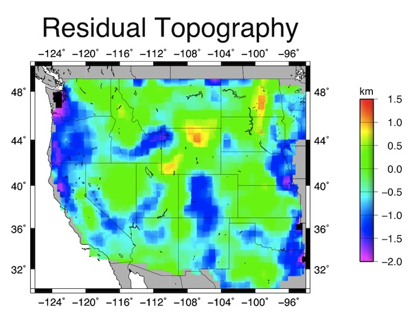
Preliminary results of residual topography of the Western U.S.: Densities are derived S-velocities from a joint inversion of surface wave dispersion curves and receiver functions. Anelasticity and flexural response are taken into account, but changes in mineralogy are not explicitly addressed. Negative residual implies pockets of high melt content (not distributed melt) or basal traction resulting from mantle flow. Positive residual may result from mantle dynamics or magnesium enrichment.
Full-resolution graphics file in original format: 0017.jpg
With a knowledge of seismic velocity structure from surface wave dispersion curves and receiver functions from the Transportable Array seismometers, we derive 3D density structure for the Western U.S. to a depth of 200 km. Crustal velocity to density scaling reflects empirical relationships between Vs and density. Mantle density is derived from velocity data from isobaric heating of olivine. We assume a compositional homogenous but thermally varying mantle and use a non-linear (i.e. anelastic) velocity perturbation-density change relationship. We then integrate the buoyancy contribution through our model (surface to 200 km depth), corrct for flexural effects with a radially symmetric Green's function or different geometry at each station and compare to modern, flexurally smoothed topography. Areas of positive residual (i.e. in reality higher than model predictions) may reflect biases to high densities in the velocity-density relationship due to iron depletion. Areas of negative residual may reflect pockets of high melt concentration that lead to diffraction, thus resulting in a low apparent velocity (though density is that of near-solidus mantle). We suspect such an effect beneath areas of high heat flow and active or recent volcanism or extension: Cascades, Walker Lane, Wasatch Front, Southern Rockies, and Snake River Plain/Yellowstone. Alternatively, downward basal normal forces resulting from mantle dynamics would explain elevations lower than those predicted from isostasy. Subduction beneath the Cascades would explain the anomalies there. We suggest that such simple isostatic models can be used to test hypotheses generated from other geological, mineralogical, and geophysical studies.
Keywords: buoyancy, isostasy, ambient_noise_tomography, receiver_function