2012 IRIS Workshop
The Salton Seismic Imaging Project: Investigating Earthquake Hazards and Rifting Processes in the Salton Trough, Southern California
G. S. Fuis: U.S. Geological Survey (USGS), J. A. Hole: Virginia Polytechnic Institute and State University (Virginia Tech), J. M. Stock: California Institute of Technology, N. W. Driscoll: Scripps Ins
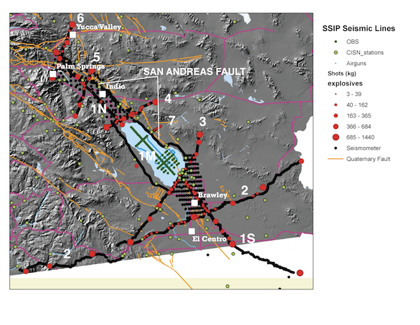
Figure 1. Map showing footprint of the Salton Seismic Imaging Project (SSIP). Major roads shown in pink. Seismic lines 1 through 7 labeled. Line 1 labeled in three segments - 1N, 1M (OBS’s and airgun shots), and 1S. Parts of SSIP from Line 7 northward are focused on earthquake hazards of the southern San Andreas fault. Parts of SSIP from Line 7 southward are focused on processes of rifting, sedimentation, and magmatism.
Full-resolution graphics file in original format: 0023.png
The Salton Seismic Imaging Project (SSIP) is a collaborative effort between academia (in the U.S.A. and Mexico) and the U.S. Geological Survey to provide subsurface seismic images of the Salton Trough of southern California and northern Mexico. From both active- and passive-source seismic data that were acquired both onshore and offshore (Salton Sea), the resulting seismic images will provide insights into earthquake hazards, rift processes, and rift-transform interaction at the southern end of the San Andreas Fault (SAF) system. The southernmost SAF is considered to be at high-risk of producing a large-magnitude damaging earthquake, yet the geometry of the SAF and other regional faults and the structure of adjacent sedimentary basins are not well understood. Active-source seismic data were acquired from 2 to 18 March 2011. Borehole explosions (126, with yields of 10-1400 kg) were detonated along seven profiles in the Salton Trough region (Fig. 1), extending from area of Palm Springs, California, to the southwestern tip of Arizona and into Mexico. Airguns (1500 and 3500 cc) were fired along two profiles in the Salton Sea and at points in a 2-D array in the southern Salton Sea. Seismometers (2586, 1- and 3-component, supplied and managed by IRIS) were deployed at more than 4200 locations throughout the Salton Trough region, and ocean-bottom seismometers (48, 4-component, supplied and managed by OBSIP) were deployed at 78 locations in the Salton Sea. Many of the onshore explosions were energetic enough to be recorded and located by the Southern California Seismograph Network. The geometry of the SAF will strongly influence energy radiation and strong ground shaking during future ruptures. The northern part of SSIP was designed to better determine fault and basin geometry, and the southern part of SSIP was designed to investigate the processes of rifting, sedimentation, and magmatism.
Acknoweldgements: The Salton Seismic Imaging Project (SSIP) is a collaborative effort between the National Science Foundation (EarthScope and [former] Margins programs) and the U.S. Geological Survey. NSF Grants NSF OCE-742263 (John Hole), OCE-0742253 (Joann Stock), and NSF-1132984 (Neal Driscoll, Graham Kent, and Alistair Harding) are acknowledged.
Keywords: earthquake_hazards, rifting, sedimentation, magmatism, tectonics