2012 IRIS Workshop
Rayleigh Wave Phase Velocity, Local Amplification, and Ellipticity Observed Across USArray: Is 3D Density Tomography in the Crust and Upper Mantle Possible?
Fan-Chi Lin: Seismolab Caltech, Brandon Schmandt: Seismolab Caltech, Victor C. Tsai: Seismolab Caltech, Michael H. Ritzwoller: University of Colorado Boulder
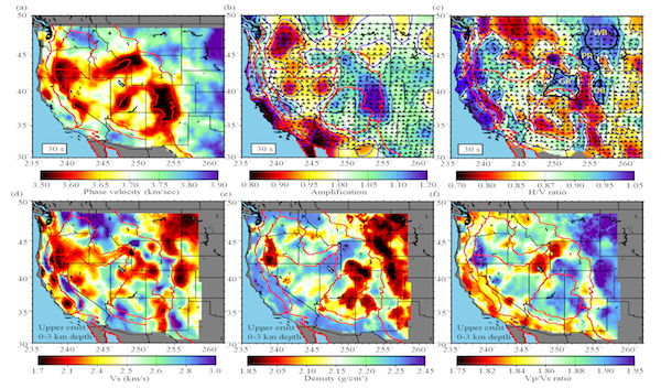
(a)-(c) 30 sec Rayleigh wave phase velocity, local amplification, and H/V ratio observed across USArray in the western US. The triangles in (b)-(c) shown the stations used. The thick black lines indicate 3-km sediment contours for several major sedimentary basins (WB: Williston Basin; PR: Powder River Basin; GR: Green River Basin; DB: Denver Basin). (d)-(f) The Vs, density, and Vp/Vs ratio in the uppermost crust (0-3 km) inverted by phase velocity and H/V ratio measurements.
Full-resolution graphics file in original format: 0024.png
Resolving 3D density structure in the crust and upper mantle is important to understand the fundamental driving force of geodynamics. Surface waves, which propagate near the earth surface, are sensitive to not only velocity structure but also density structure. Traditional surface wave tomography based on phase and group velocity measurements, however, do not have the ability to resolve density structure due to the tradeoff between different parameters. Here, we show that with Rayleigh wave phase velocity, local amplification, and ellipticity (H/V ratio) observed in the western US across the USArray, 3D velocity and density structure in the crust and upper mantle can be better constrained. To construct Rayleigh wave phase velocity maps between 8 and 100 sec period, we apply eikonal and Helmholtz tomography to ambient noise and earthquake dataset. Local amplification, which describes the effect of local structure on the observed surface wave amplitude, is a new type of measurement that can be used in a tomography inversion. Slight modification of Helmholtz tomography allows us to study amplitude variation due to local amplification accounted for focusing/defocusing and attenuation effects. Both local amplification and H/V (radial to vertical) ratio maps are constructed between 24 and 100 sec periods based on earthquake measurements and are correlated well with known geological features. By jointly inverting phase velocity and H/V ratio, the uppermost crust is in particularly better resolved, with pronounce low Vs, low density, and high Vp/Vs anomalies imaged in the locations of several major sedimentary basins including the Williston, Powder River, Green River, Denver, and San Juan basins. Evidence of deeper density anomalies can also be observed when model-predicted local amplification and H/V ratio are compared with observations.
Acknoweldgements: Instruments (data) used in this study were made available through EarthScope (EAR-0323309), supported by the National Science Foundation (NSF). The facilities of the IRIS Data Management System were used for access the waveform and metadata required in this study. The IRIS DMS is funded through the NSF under Cooperative Agreement EAR-0552316. This research was supported by the Director’s Post-Doctoral Fellowship of the Seismological Laboratory at the California Institute of Technology.
For further reading: Lin, F., V.C. Tsai, and M.H. Ritzwoller, The local amplification of surface waves: A new observable to constrain elastic velocities, density, and anelastic attenuation, submitted to J. Geophys. Res. Lin, F., B. Schmandt, and V.C. Tsai, Joint inversion of Rayleigh wave phase velocity and ellipticity using USArray: constraining velocity and density structure in the upper crust, in preparation.
Keywords: surface_wave, tomography, amplification, h_v_ratio