2012 IRIS Workshop
Crustal Thickness and Velocity Structure Across the Bighorn Mountains, Northern Wyoming: Insights into Laramide-style Orogenesis from the Bighorn Arch Seismic Experiment (BASE)
Lindsay L. Worthington: Texas A&M University, William L. Yeck: University of Colorado at Boulder, Kate C. Miller: Texas A&M University, Anne F. Sheehan: University of Colorado at Boulder, Eric A. Ersl:
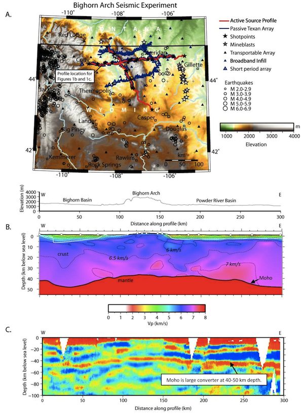
Figure 1. A) Study area and survey geometry for Bighorn Arch Seismic Experiment; Elevation profile across east-west seismic line shown in Figures 1B and 1C. B) Seismic P-wave velocity model across Bighorn Arch derived from tomographic inversion of travel-time data from 21 lithospheric shots. C) Common conversion point (CCP) stack of teleseismic receiver functions. Receiver functions were deconvolved in the time domain with a Gaussian filter-width parameter (a) of 2.
Full-resolution graphics file in original format: 0032.jpg
Basement-involved foreland arches, such as the Bighorn Arch in north-central Wyoming, are typical of Laramide-style orogenesis; however, the mode of arch shortening at depth remains unresolved due to lack of geophysical imaging. The 2010 NSF-EarthScope Bighorn Arch Seismic Experiment (BASE) was an integrated active- and passive-source study designed to image the crust and mantle below the Bighorn Arch, providing constraints for understanding the structural evolution of basement-cored foreland arches. The BASE data set includes over 210 (38 broadband + 172 short period) three-component EarthScope Flexible Array (FA) seismic stations folded into the concurrent EarthScope Transportable Array (TA) network. Our FA broadband stations were configured to densify the TA grid from 70 km spacing to 35 km spacing. BASE’s short-period seismometers were placed along 5 linear transects with station spacing of 5-11 km. The active-source component of BASE includes data from 21 seismic shots recorded on ~1800 4.5 Hz vertical component geophones and ‘Texan’ dataloggers deployed in one east-west profile and one north-south profile. We present current results from both tomographic inversion of the active-source data (Figure 1b) and common conversion point (CCP) stacking of teleseismic P-S wave receiver functions (Figure 1c) along an east-west profile across the Bighorn Arch. Moho depth across the profile varies between ~38-50 km (Figures 1b, 1c), deepening gradually beneath the bounding basins on either side of the Arch. The shallowest Moho is located beneath the Arch. The absence of large scale offsets of the Moho favors arch formation by crustal detachment, perhaps partially controlled by a preexisting Moho high beneath the arch. This interpretation is consistent with structural modeling that suggests listric thrusting on a west-dipping master fault that flattens at ~30 km depth.
Acknoweldgements: Funding provided through NSF-EarthScope awards EAR-1157150, EAR-0843657, EAR-0844202. Additional funding through Air Force Research Laboratory Contract No. FA9453-10-C-0214. Technical, instrumentation and field support through IRIS-PASSCAL.
Keywords: tomography, active_source_seismology, receiver_function, orogenesis