2012 IRIS Workshop
Capturing Small-Scale Seismicity with EarthScope's USArray Transportable Array
Jeffrey S. Lockridge: School of Earth and Space Exploration, Arizona State University; Matthew J. Fouch: Department of Terrestrial Magnetism, Carnegie Institution of Washington; J Ramon Arrowsmith: S
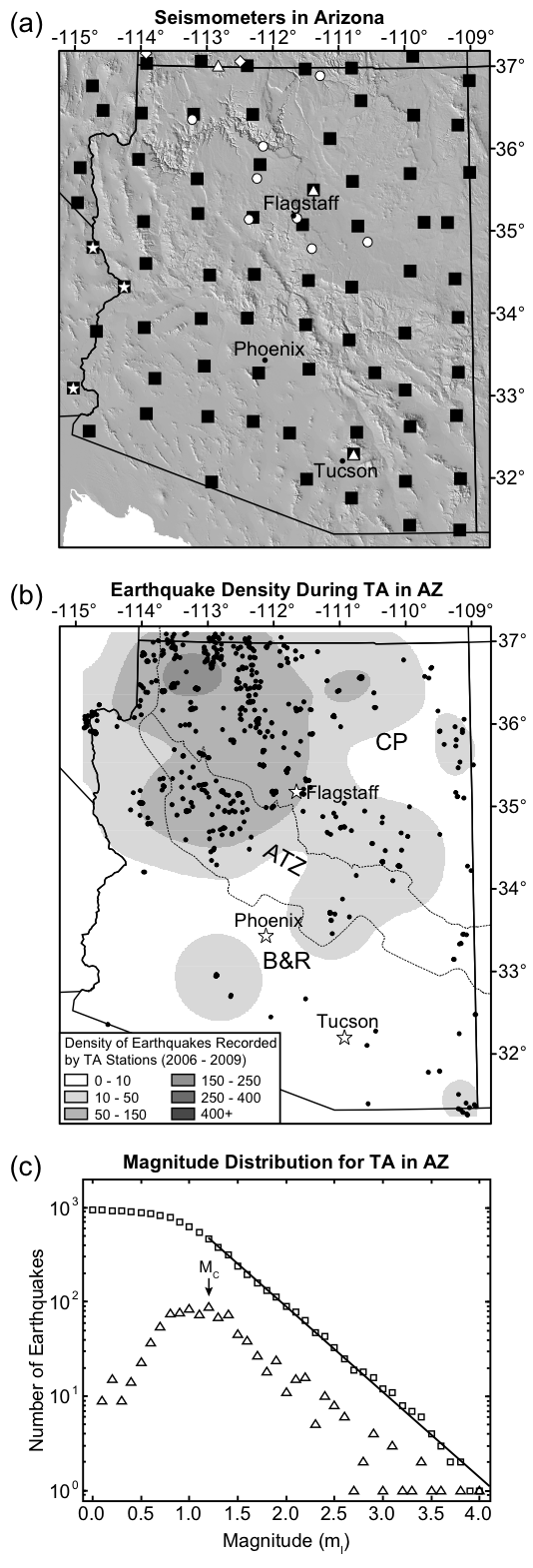
(a) Distribution of seismic stations from the USArray Transportable Array (TA; black squares) and semi-permanent regional/national networks (white symbols). (b) Density (shaded areas) and distribution of earthquakes (black dots) within Arizona during the deployment of the TA from 2006 to 2009. (c) Earthquake magnitude frequency distribution of events recorded by TA stations and showing a completeness magnitude (MC) of ml 1.2 for this catalog.
Full-resolution graphics file in original format: 0033.ai
The EarthScope USArray Transportable Array (TA) provides an opportunity to capture, for the first time small-magnitude seismicity on a regional scale with even network coverage. We used TA data from stations within Arizona to develop an earthquake catalog that is complete to ml ~1.2 and contains crustal events as small as ml 0.0. Our methods represent a significant improvement over other event catalogs that recorded earthquakes in Arizona from April 2007 to November 2008; while the ANSS catalog contained 76 events, the AEIC contained 4 events, and the ANF catalog contained 248 events, our event catalog contained 884 earthquakes, including over 600 unique events. This increased detection threshold enabled us to detected several previously unidentified areas of seismic activity in Arizona, suggesting that most regions of the state are capable of producing small-magnitude earthquakes. We also identified 16 earthquake clusters, many of which have swarm-like behavior. These swarms and clusters account for 42% of the seismic events that occurred during the TA deployment in Arizona, occur in all physiographic, geophysical and tectonic settings, and may represent an important mechanism for small-scale tectonic strain release within intraplate regions with apparently low seismicity levels. We are presently using the same methods to develop an earthquake catalog for the Great Basin region of Nevada and western Utah using TA data. A new small-magnitude seismicity catalog in this region will provide additional constraints on the tectonic evolution of this enigmatic region.
Acknoweldgements: This work was supported by the Arizona Geological Survey / Arizona Department of Emergency Management via a grant from the Federal Emergency Management Agency, and by the National Science Foundation via an EarthScope Science CAREER grant to MJF (EAR-0548288).
For further reading: J. S. Lockridge, M. J. Fouch and J R. Arrowsmith, Seismicity within Arizona during the Deployment of the EarthScope USArray Transportable Array, in press, Bull. Seis. Soc. Am., 2012.
Keywords: earthscope, usarray, seismicity, colorado_plateau, basin_and_range