2012 IRIS Workshop
PICASSO: Lithosphere Structure in the Western Mediterranean from Ps Receiver Functions and Rayleigh Wave Tomography
I. Palomeras: Rice University, S. Thurner: Rice Unversity, K. Liu: Rice University, A. Levander: Rice University, J. Gallard: ICTJA-CSIC
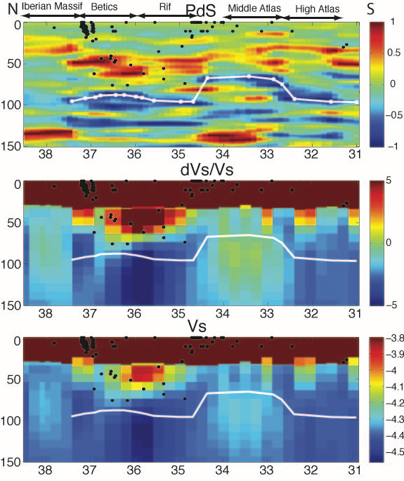
Profile in the Western Mediterranean comparing the receiver function and Rayleigh wave tomography results from the PICASSO survey. The profile runs from the Moroccan-Algerian border to the center of Iberia. Results from the RFs and SWs agree well, both showing a variable LAB depth (white line) throughout the region. The LAB is located at ~100 km depth beneath the Iberian Massif , Betics and Rif, shallows beneath the Middle Atlas up to ~70 km depth, and then thickens again beneath the High Atlas.
Full-resolution graphics file in original format: 0036.jpg
The western Mediterranean is a diffuse plate boundary separating the African and Eurasian plates. Cenozoic deformation is centered on the Gibraltar arc and Alboran Sea, and occupies a wide area from the southern Iberian Massif to the Atlas Mountains. We present a model of the lithospheric structure of this region derived from Rayleigh wave (RW) tomography and Ps receiver functions, using data from the PICASSO (Program to Investigate Convective Alboran Sea System Overturn) broadband array of ≥100 seismographs. This array is deployed from central Spain to the Morocco-Algerian border. We complement these data with some of that recorded by IberArray, an areal broadband array, operated by the Spanish seismological community, covering the same region. Rayleigh phase velocities have been measured from 20-167s period using the two-plane-wave method, and finite-frequency kernels to improve lateral resolution. The phase velocities were inverted for 1D structure. Ps receiver functions at 1Hz and 2Hz were calculated for the same area, and were then CCP stacked. The RW shear velocity model, jointly interpreted with the discontinuity structure from the CCP stack, shows the first-order lithospheric structure, and the lithosphere-asthenosphere boundary (LAB). Results show: the lithosphere is ≥100 km thick beneath the Iberian Massif, where it has the highest shear velocity, 4.45 km/s. To the south the lithosphere thins beneath the Betic Mountains to ≥90 km, and then varies in thickness and decreases in velocity beneath the Alboran Sea and Gibraltar Arc. The thinnest lithosphere, ≥70 km, is observed beneath the Rif Mountains and Middle Atlas, with a low velocity feature (4.2 km/s) at this depth. The lithosphere thickens again beneath the High Atlas and the Sahara Platform (≥100 km) where the upper mantle shear velocity increases (≥4.40 km/s). The CCP images show complicated crustal and upper mantle structures under the Betics.
Acknoweldgements: This research is part of the PICASSO projects funded by NSF grant EAR-0808939. Data from the Consolider-Ingeino 2010 project TopoIberia, funded by the Spanish government (CSD2006-00041), has also been used.
Keywords: receiver_function, surface_wave_tomography, western_mediterranean