2012 IRIS Workshop
Imaging the Forearc in South-Central Chile Using Receiver Function Migration and Ambient Noise Tomography
Mallory Morell: Univ. of Arizona, Kevin M. Ward: Univ. of Arizona, Susan L. Beck: Univ. of Arizona, Steve Roecker: Rensselaer Politechnic Inst., Anne Meltzer: Lehigh Univ., Lucy Brown: Lehigh Univ.
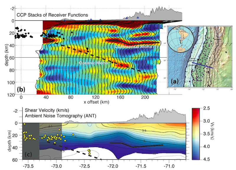
Cross-section images of receiver functions (RFs) and ambient noise tomography (ANT) of the Chile forearc using IMAD seismic data. (a) Location map with IMAD broadband seismic stations . (b) CCP RF Stack with bin spacing of 5km in the E-W direction and 20km in the N-S direction, migrated with Vp of 6.5km/s and a Vp/Vs of 1.78 to 35km and Vp=8km/s below 35km. (c) Cross-section of shear wave velocities from ANT. Earthquake locations are from Meltzer et al. (2010). Slab contours from the NEIC.
Full-resolution graphics file in original format: 0041.jpg
The Mw=8.8 Maule earthquake that occurred off the coast of Chile on February 27, 2010, ruptured ~600 km of the plate boundary. This segment of the Nazca-South America plate boundary is an ideal region to investigate the processes related to the structure of the down-dip edge of the seismogenic zone, forearc and subducting slab. Immediately after the Maule earthquake, international teams from France, Germany, Great Britain and the United States joined Chilean seismologists to install broadband seismic stations between 33°-38.5°S, from the coast to the foothills of the Andes to produce the International Maule Aftershock Deployment (IMAD) data set. We calculated receiver functions (RFs) from teleseismic P and PP phases and constructed common conversion point stacks using a simple 1-D velocity for the migration following the method of Gilbert and Sheehan (2004). We have identified the oceanic slab Moho on several E-W and N-S profiles at 30 to 80 km depth and the continental Moho at ~35 km depth beneath the foothills of the Andes. We used broadband seismic data from the IMAD and surrounding temporary and permanent stations to determine a shear wave velocity model using Ambient Noise Tomography (ANT). We followed the method of Bensen et al. (2005) to construct phase velocity maps for periods between 8 and 40 sec and then inverted for the shear velocity every 0.1°. We find that the forearc has fast shear wave velocities especially compared to the active arc where we observe slow shear wave velocities throughout the mid and lower crust. At lower crustal depth (~25 km) the forearc appears to be segmented reflecting basement structures. Both these techniques improve our imaging of the forearc, continental Moho, and subducted slab.
Acknoweldgements: We thank all the participants of the IMAD deployment teams for making their data open. We especially thank Sergio Barrientos, Klaus Bataille, Diana Comte, Andreas Rietbrock, Fredrick Tilmann, Ben Heit, Dietrich Lange, Pascal Bernard, Jean-Pierra Vilotte and the entire IRIS CHAMP team. This work was supported by NSF awards 1045597, 1036352, and 1036349.
For further reading: Bensen, G. D., M. H. Ritzwoller, M. P. Barmin, A. L. Levshin, F. Lin, M. P. Moschetti, N. M. Shapiro, and Y. Yang (2007), Processing seismic ambient noise data to obtain reliable broad band surface wave dispersion measurements, Geophys. J. Inter., 169(3), 1239-1260. Gilbert, H.J. and A.F. Sheehan (2004), Images of crustal variations in the intermountain west, J. Geophys. Res., 109, B03306.
Keywords: chile, forearc, receiver_function, ambient_noise_tomography