2012 IRIS Workshop
The CDPapua Experiment: A Seismological Investigation of the Woodlark Rift, Papua New Guinea
Z. Eilon: Lamont-Doherty Earth Observatory of Columbia University, Palisades, NY USA, YH. Kim: Lamont-Doherty Earth Observatory of Columbia University, Palisades, NY USA, G.A. Abers : Lamont-Doherty
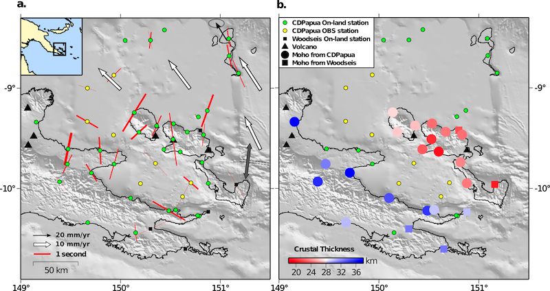
Map of study region, with preliminary results: a) shear wave splitting observations (fast axis) with thickness proportional to certainty of observations (more thick corresponds to smaller estimated error); b) Moho depths constrained by receiver functions. This plot contains data from the current experiment (CDPapua) as well as a 1999-2000 deployment (Woodseis). Black arrow: GPS velocity; white arrows: calculated plate motions (w.r.t. stable Australia)[2]; grey arrow: ridge spreading direction.
Full-resolution graphics file in original format: 0065.png
The Woodlark Rift, in Papua New Guinea, manifests a complete range of continental rifting, from full seafloor spreading in the east to incipient continental extension in the west. Intermediate between these extremes lie the gneiss domes of the D’Entrecasteaux Islands, which sit on relatively thinned continental crust that is thought to have accommodated up to 200km of extension. 7-8Ma UHP (coesite-eclogite) rocks within these domes indicate 15 km/Ma exhumation from 100 km depths coeval with extension[1]. This rapid exhumation has been variously attributed to simple-shear-type extension on a low-angle detatchment to the north (with the inference that the gneiss domes are akin to Metamorphic Core Complexes) or Rayleigh-Taylor diapirism of felsic material related to Eocene subduction. We installed a 39-station broadband seismic array comprising 8 ocean-bottom broadband seismographs and 31 land-based PASSCAL broadband instruments, which operated in the region of core complex formation from March 2010 to mid-2011. Our data provide the first detailed seismological constraints on the deep structure of this complex region. Early shear-wave splitting results indicate a coherent N-S fabric beneath the D’Entrecasteaux, and to the north, evinced by approximately NNE fast azimuths, with significant (<2 seconds) splitting times; this azimuth agrees well with GPS velocities for rifting[2]. Within the Goodenough Basin, and to the south, complex splitting is observed, perhaps a reflection of complicated structure at depth. We hope that further analysis, reinforced by modelling may allow us to resolve the compatibility of these splitting results with the differential predictions of mantle flow driven by large-scale extension as opposed to ascending diapirs. Preliminary receiver function analysis broadly supports previous studies[3] and reveal ~10km of thinning from average crustal thicknesses on the Papuan peninsula of ~34km compared to ~23km beneath the putative MCCs.
Acknoweldgements: Funding provided by the U.S. National Science Foundation, Continental Dynamics program (awards EAR-081423 and EAR-07084450), and international partners. Instruments supported by theIRIS-PASSCAL Instrument Centerand theOBSIP Instrument Pool.
For further reading: [1] Baldwin & Fitzgerald, (2012). Tectonics of the New Guinea Region. Annu. Rev. Earth Planet. Sci., 40:495–520. [2] Wallace, (2004). GPS and seismological constraints on active tectonics and arc-continent collision in Papua New Guinea: Implications for mechanics of microplate rotations in a plate boundary zone. J. Geophys. Res., 109(B5). [3] Abers et al., (2002). Mantle compensation of active metamorphic core complexes at Woodlark rift in Papua New Guinea. Nature, 418(6900), 862–865.
Keywords: shear_wave_splitting, receiver_function, woodlark_rift, dentrecasteaux, anisotropy, continental_rifting