2012 IRIS Workshop
Real-Time Observation of EF3 Tornado Passage Near USArray TA Station Y46A on 4/27/2011
Jonathan Tytell: UC San Diego, Frank Vernon: UC San Diego, Jennifer Eakins: UC San Diego
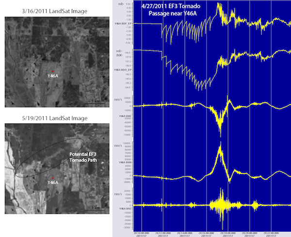
Upper left image shows a Landsat picture from 3/16/2011 with USArray TA station Y46A indicated with a red dot. Approximate scale represented at bottom right of this image. Lower left image is similar but for 5/19/2011 with the potential EF3 tornado path from 4/27/2011 circled. Right image shows raw data from during tornado passage on 4/27/2011. All data is 40 sps. Top panel is infrasound, then Setra 278 barometric pressure, then east, north and finally vertical seismic at the bottom.
Full-resolution graphics file in original format: 0069.png
This abstract follows a case study in which an EF3 tornado made a close passage (~ 1 km) from USArray TA station Y46A on 4/27/2011 in northeast Mississippi. What makes this case study particularly unique is the large spike within the horizontal seismic channels indicating a discernible "tug" of the upper crust toward the northwest. The increase and decrease of crustal speed occurs within ~ 1.5 minutes in total. Further work will be done to determine how much energy was transferred into the crust during this pass-by as well as any potential for now-casting tornado passages within the USArray TA data.
Acknoweldgements: The writers of this abstract would like to thank the National Science Foundation, the Earthscope program, and IRIS for providing us the opportunity to conduct this unique research.
For further reading: NASA's Landsat program: http://landsat.gsfc.nasa.gov/
Keywords: usarray, seismology, tornado, infrasound