2012 IRIS Workshop
The ANF Seismic Bulletin
L. Astiz:, J. A. Eakins:, V. M. Martynov:, T. A. Cox:, J. Tytell:, G.H. Karasu:, R.L. Newman:, J. C. Reyes:, G. A. Davis:, F.L. Vernon: All at U.C. San Diego, Scripps Institution of Oceanography
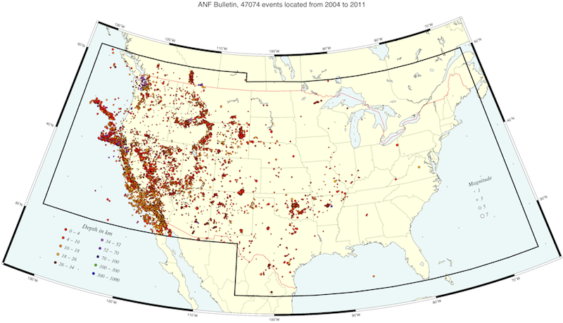
Seismicity map of the continental U. S. showing the western plate boundary as well as the broad zone of deformation to the East of the Basin and Range province and the Snake River Plain. Large clusters of activity that occur only during local daylight hours may be related to mining activity. The ANF produces special event pages for regional earthquakes with M > 5.0 and for smaller events of interest in regions of low seismicity (http://anf.ucsd.edu/spevents).
Full-resolution graphics file in original format: 0085.ps
Originally viewed as a quality assurance tool, the Array Network Facility (ANF) analysts review seismic arrivals recorded by the USArray Transportable Array (TA) and contributing regional seismic stations to locate regional seismicity within the footprint of the array. Through December 2011, ANF seismic analysts have picked over 5.4M seismic arrivals, of which 3.7 million are from teleseismic events that have been associated with the NEIC earthquake bulletin. These teleseismic arrivals have been used to construct increasingly refined tomographic images under the continental U.S. (e.g, Burdick et al., 2008, 2012). The remaining 1.7 million arrivals were generated by almost 50,000 events located within the continental U.S. with hypocentral solutions produced using the iaspei91 velocity model. The origin-time standard error mean for these events is 0.475 sec. Local magnitudes (Ml) have been determined for these events and, when available, the arrivals have been associated with origins reported by regional seismic networks. The gridded distribution of USArray stations, use of a common location technique, consistency of arrival picking by ANF analysts, and a final review process of all events, has provided an image of seismicity within the continental U.S. to about 90° longitude West that is comprehensive and unbiased (Figure 1). The USArray has been instrumental in highlighting zones of seismicity east of the Rocky Mountains as well as central North America, where regional seismic networks are sparse. For example, the recent Oklahoma and Arkansas seismic activity has been well recorded by nearby TA stations and the presence of broadband telemetered seismic stations in this region has added to the available catalog of events. We note that although about 50% of all events located by the ANF until December 2011 have not been reported by any other regional seismic bulletin, many of these could be quarry blasts that are mostly not reported by regional networks.
Acknoweldgements: This material is based upon work supported by the Incorporated Research Institutions for Seismology under their Cooperative Agreement No. EAR-0733069 with the National Science Foundation.
For further reading: Burdick, S.,Ch.Li,V.Martynov,T.Cox, J.Eakins,T.Mulder,L.Astiz,F.L.Vernon,G.L.Pavlis and R.D.van der Hilst (2008). Upper Mantle Heterogeneity beneath North America from Travel Time Tomography with Global and USArray Transportable Array Data. Seism. Res. Lett., 79, No. 3. p-384-392. ----- Burdick,S., R.D. van der Hilst, F.L.Vernon,V.Martynov, T.Cox, J.Eakins, G.H.Karasu, J.Tytell, L.Astiz and G.L.Pavlis (2012). Model Update March 2011: Upper Mantle Heterogenity..., Seism. Res. Lett. 83, no. 1, p-23-28 doi: 10.1785/gssrl.79.3.384
Keywords: seismicity