2012 IRIS Workshop
Ambient Noise Tomography of the Central Andes
Kevin M. Ward: The University of Arizona, Ryan Porter: Carnegie Institution of Washington, George Zandt: The University of Arizona, Susan L. Beck: The University of Arizona, Estela Minaya: El Observat
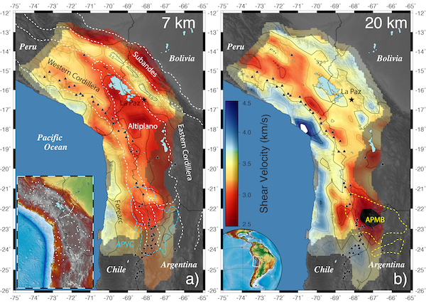
Ambient Noise Tomography results for 7 and 20 km depths in the Central Andes. a) Shear velocities (Vs) at 7 km show good correlation with morphotectonic units. b) At 20 km, a zone of low Vs (<3.25 km/ s) tracks the active volcanic arc. Lowest Vs (<2.75 km/s) correlates with the Altiplano-Puna magma body (APMB) located in the Altiplano- Puna volcanic center (APVC). Black triangles represent Holocene volcanoes. Seismic stations used in this study are shown as white diamonds in the inset map.
Full-resolution graphics file in original format: 0091.jpg
We use data from 149 broadband stations from 11 different international seismic networks, deployed incrementally in the Central Andes from May 1994 through March 2012, to image the crust using ambient noise tomography. Using the vertical component, we extract ambient noise from the wave field and calculate dispersion curves for each station pair available. Using all available station pair paths, we invert for 2-d phase velocity maps for periods between 8s and 40s. Our final step is inverting for the S-wave velocity (Vs) structure at horizontal intervals of 0.1° by 0.1° using a constant 4.2 km/s starting model. We have good resolution of Vs in the crust to a depth of ~50 km from approximately 13°S to 24°S. Figure 1 shows maps of Vs contoured at an interval of 0.25 km/s at depth slices of 7 and 20 km. ”Bright” areas represent good resolution (<100 km) and “dull” areas represent poorer resolution (100-800km) as defined from the phase velocity measurements. At 7 km depth, we observe low Vs (<3.25) within the Altiplano basin, and slower velocities within the deeper subbasins. We also observe low Vs associated with the Subandean thin-skinned fold and thrust belt. A narrow corridor of high velocities within the Eastern Cordillera correlates with the high peaks of the Cordillera Real where Triassic and Cenozoic plutons are exhumed. At 20 km depth, the forearc region appears as a high velocity (>3.5) zone and the active volcanic arc parallels a zone of low velocities (<3.25) that may demark the modern batholith. Also at these depths, there are more localized low velocity anomalies near the major active volcanoes that may represent anomalously high temperatures or the presence of small amounts of partial melt. Between 21 and 23°S a region of very low Vs (<2.75) defines the Altiplano-Puna magma body (APMB) that underlies the Altiplano-Puna volcanic center (APVC). A smaller satellite low-velocity body is located to the west of the act
Acknoweldgements: This work was supported by NSF award #0907880, and #0943991. We thank IRIS PASSCAL for providing seismic instrumentation and the IRIS DMC for archiving the data. We would like to acknowledge all of those who helped to deploy, maintain, and service the seismic stations from the 11 different international networks. We also thank all the PIs from the PLUTON experiment for sharing their restricted data.
Keywords: central_andes, ambient_noise_tomography