2012 IRIS Workshop
Imaging Crustal Radial Anisotropy Structure in the Eastern Tibetan Plateau Using Ambient Noise
Jiayi Xie:U. Colorado, Michael H. Ritzwoller:U. Colorado
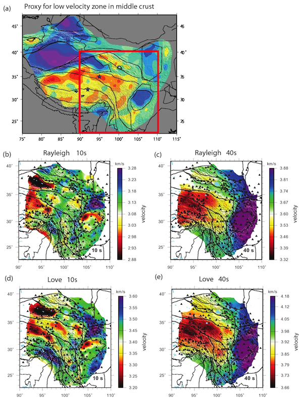
(a) Map showing the distribution of the mid-crustal Vsv low velocity zone (LVZ) across Tibet (Yang et al., 2012, Fig. 6), where reds indicate the presence of the LVZ. Red rectangle is the study region. (b) & (c) Ambient noise Rayleigh wave phase velocity maps, stations shown with triangles. (d) & (e) Love wave maps. The goal is to model the extent and geometry of crustal radial anisotropy to determine whether the crustal LVZ in Tibet is caused by partial melt or anisotropic crystal alignment.
Full-resolution graphics file in original format: 0107.jpg
Acknoweldgements: The work was supported by US NSF-EAR award 0944022, and US NSF-OISE sub-award 0730154. Most of the waveform data for this study were provided by the Data Management Centre of the China National Seismic Network at the Institute of Geophysics, China Earthquake Administration. In addition, the facilities of the IRIS Data Management System were used to access data required in this study. The IRIS DMS is funded through the US National Science Foundation under Cooperative Agreement EAR-0552316.
For further reading: Yang, Y., M. H. Ritzwoller, Y. Zheng, W. Shen, A. L. Levshin, and Z. Xie (2012), A synoptic view of the distribution and connectivity of the mid-crustal low velocity zone beneath Tibet, J. Geophys. Res., 117, 20 PP., doi:10.1029/2011JB008810. doi: 10.1029/2011JB008810
Keywords: ambient_noise_tomography, radial_anisotropy