2012 IRIS Workshop
Near Surface Exposures of Megathrust Splay Faults in Prince William Sound, Alaska
Shaun Finn: Boise State University, Lee Liberty: Boise State University
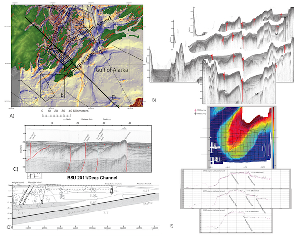
A) Map of PWS shows the bathymetry derivative and faults (red lines) with seismic lines(black). B)Seismic profiles from Montague Strait with faults interpretations (red). C) High resolution seismic profile from southwest of Montague Island showing splay faults deforming near surface strata. D) Summary cross-section for PWS with earthquake data (Doser et al., 2009), velocity structure (Brocher et al., 1994), Montague Island faults (Plafker, 1969). E) Differencing of pre- and post-1964 bathymetry.
Full-resolution graphics file in original format: 0109.png
New sparker seismic data along with relic airgun marine datasets document the complex interplay between glacial, sediment, and tectonic processes in Prince William Sound (PWS), Alaska. While glaciation reset the regional topography approximately 10 ka and multiple sediment sources produce laterally and temporally varying stratigraphy, we identify new splay faults with measurable water bottom and pre-Holocene sediment offsets. Seismic profiles and high resolution bathymetry record a dense network of splay faults from the outer arc high to the forearc and across presumed megathrust segment boundaries. These splay faults emerge from a mid-crustal decollement and deform Holocene and older strata. The last glacial maximum represents a time horizon to measure both Holocene deformation rates and along-strike fault variability. Active faults extend along strike from eastern Prince William Sound to offshore, although uplift rates appear less to the east and west of Montague Island. Three faults uplifted Montague Island during the Great Alaska 1964 earthquake. The Patton Bay fault and parallel offshore fault (we term son-of-Patton Bay fault) continue offshore from Montague Island. Bathymetric differences between pre- and post-1964 surveys show significant uplift during the Great Alaska 1964 Earthquake. Newly identified faults inland of Montague Island appear to offset water bottom and older strata and likely ruptured during the 1964 earthquake. Other splay faults offset older strata but do not appear to have ruptured during the last few earthquake cycles. Ongoing analysis and data integration will result in Holocene fault distribution maps and document fault slip rates throughout Prince William Sound and Gulf of Alaska.
Acknoweldgements: We would like to acknowledge our collaborators Peter Haeussler and Thomas Pratt from the USGS. We would like to thank the USGS Alaska Science Center for the use of the R/V Alaskan Gyre and boat captain Greg Snedgen for his help during acquisition. USGS Research Grants Award No. G09AP00049 USGS Research Grants Award No. G11AP20143 USGS Research Grants Award No. G12AP20078
Keywords: splay_faults, marine_seismic, megathrust, subduction_zone