2012 IRIS Workshop
Hidden Hotspot Track beneath Eastern United States
Risheng Chu: Caltech; Wei Leng: Caltech; Don V Helmberger: Caltech; Michael Gurnis: Caltech
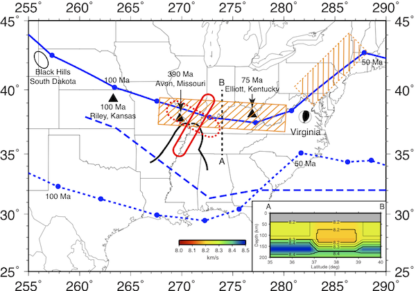
Relationship of hidden lower lithosphere tracks, motion path of North American plate relative to the asthenosphere (solid blue line), and surface features. The weakened lower lithosphere is denoted by the rectangular box. The east-west track is well established with a 2D cross-section given in the inset with the lower lithosphere mostly removed. The heavy black contour delineates the Mississippi Embayment. Black triangles denote kimberlite intrusions with age labeled.
Full-resolution graphics file in original format: 0110.ai
In eastern United States, seismic waveforms recorded by USArray from a recent Virginia earthquake reveal an unexpected linear, lower lithosphere seismic anomaly extending from Missouri to Virginia without a clear relationship to surface geology. The prominent anomaly, P-velocity reduced by 2.1% with a width of about 250 km, is oriented east west and crosscuts prominent regional features suggesting a link to plate motions. We show that a thermal plume-like upwelling interacting with the base of the continental lithosphere can produce the requisite seismic signal. A Late Cretaceous kimberlite in Kentucky, dated 75 Ma, pins a hotspot track that bends NE in Virginia. Seismic data indicates that the lower lithospheric anomaly along this NE segment is even stronger than the EW segment, supporting such a hypothesis.
Acknoweldgements: All seismic waveform data are downloaded from IRIS data management center. This work is supported by the National Science Foundation through grant numbers EAR-0855815, EAR-0810303, and CMMI-1028978. This is contribution number 10074 of the Division of Geological and Planetary Sciences, California Institute of Technology.
Keywords: lithosphere, hotspot