2012 IRIS Workshop
Rayleigh Waves from the PLUME Network Document Asymmetric Lithosphere and Asthenosphere Structure beneath the Hawaiian Swell
Gabi Laske: Scripps Institution of Oceanography, John A. Collins: Woods Hole Oceanographic Institution, Cecily J. Wolfe: University of Hawaii at Manoa
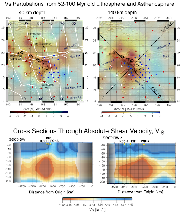
Top: Two maps of the shear velocity model resulting from Rayleigh wave tomography, overlaid on grey-shaded bathymetric relief. White lines denote contours of crustal age in Myr. Black lines mark the locations of the cross-sections shown on the bottom. The labels ‘V.F.’, ‘S.M.’ and ‘F.Z.’ stand for ‘volcanic field,’ ‘seamount’ and ‘fracture zone.’ Blue, red and white symbols mark the locations of the PLUME 2005/2006 and 2006/2007 deployments as well as the 1997 SWELL pilot experiment. Bottom: Cross-sections through the VS model on the top, now displayed as absolute velocities. Structure near the ends of the profiles is poorly resolved and therefore has been shaded out. The projections of land stations POHA, KIP and KCCH on the islands of Hawaii, Oahu and Kauai onto the sections are also marked.
Full-resolution graphics file in original format: 0123.ai
Hawaii has long been viewed as the textbook example of a hotspot that is fed by a deep-rooted mantle plume although other models based on a much shallower origin have been considered to explain Hawaii's island chain. One of the reasons for the diverse plethora of models has been the lack of convincing seismic constraints. Relying on land seismic stations alone, HawaiiŐs isolated location in the middle of the ocean and its small spatial extent had made it difficult to obtain comprehensive seismic images. Two amphibious deployments for the Plume-Lithosphere-Undersea-Mantle Experiment (PLUME) from 2005 through 2007 provided, for the first time, body wave travel time data across a nearly 1000-km wide network. Tomographic inversions of these data clearly hint a lower-mantle connection of low seismic velocity anomalies detected in the upper mantle (Wolfe et al. 2009). A concurrent Rayleigh wave study imaged a pronounced low-velocity anomaly in the asthenosphere to the west of the island of Hawaii. The anomaly is rather confined, about 100 km wide and 300 km long, at depths below 60 km and reaching at least as deep as 140 km. The magnitude of the seismic anomaly is consistent with an excess temperature of 200-250ĽC and partial melt at the level of a few percent by volume, if we assume that compositional variations as a result of melt extraction play a minor role. The asymmetry of structure with respect to the island chain, that reflects the asymmetry in bathymetry, continues upward into the lower lithosphere but the low-velocity anomaly migrates upward and eastward toward the north of the island of Hawaii. The migrating low velocity anomaly may trace the pathway through which Hawaiian magmas reach the surface. The upper lithosphere also exhibits scattered small-scale anomalies that appear to correlate with relatively recent seafloor volcanism.
Acknoweldgements: The waveforms from this OBSIP experiment are available at the IRIS-DMC. This research was financed by the National Science Foundation under grants OCE-00-02470 and OCE-00-02819.
For further reading: Laske, G., Markee, A., Orcutt, J.A., Wolfe, C.J., Collins, J.A., Solomon, S. C. , Detrick, R. S., Bercovici, D. and Hauri, E. H., 2011. Asymmetric shallow mantle structure beneath the Hawaiian Swell—evidence from Rayleigh waves recorded by the PLUME network, Geophys. J. Int., 187, 1725-1742.
Keywords: surface_wave_tomography, mantle_plumes, ocean_bottom_seismometers