2012 IRIS Workshop
Precise Relative Relocation of Oceanic Transform Fault Earthquakes Using Rayleigh-Waveforms
K. M. Cleveland: Penn State, T. F. VanDeMark: AFTAC, C. J. Ammon: Penn State
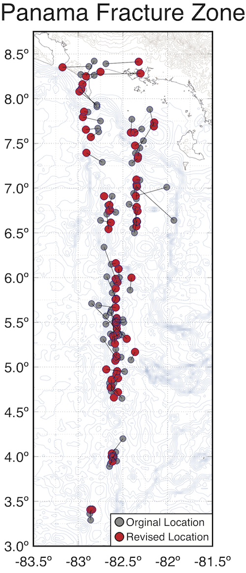
We used Rayleigh-wave cross-correlation to calculated improved relative centroid locations of 78 events (Mw 4.7 - 6.5) along the Panama and Balboa Fracture Zones (PFZ and BFZ). Gray circles display the original epicenters (NEIC catalog). Red circles show the relative centroid locations we calculated. The PFZ is better outlined as a relatively smooth, continuous feature containing westward bend beginning near 6N. The parallel fault to the east of the PFZ between 6.5N and 7.5N is the BFZ.
Full-resolution graphics file in original format: 0130.ai
Earthquake locations are fundamental parameters necessary for the in situ study of earthquake physics and faulting and are needed to map and to quantify Earth’s deformation. Within dense continental seismic networks, earthquakes can be accurately and precisely located. However, for many important tectonic environments, existing catalog data are neither accurate nor precise. In particular, for isolated continental and offshore areas, earthquake locations are estimated primarily using distant observations. The limited observations result in inaccurate and imprecise locations. Surface waves have an important sensitivity to earthquake location and their low phase velocities result in a significant sensitivity to centroid location. Cross-correlated R1 phases can contribute valuable information on earthquake location. These same characteristics of surface waves have been used to successfully image the moment release during large earthquakes using empirical Green functions (e.g. Ammon et al., 1993; Ammon et al., 1994; Velasco et al., 1995). Thus, if we can precisely measure surface wave phase shifts we can provide relatively tight constraints on an earthquake’s centroid position. We demonstrate these ideas with applications that show the value of using surface-waves to estimate relative earthquake locations. We use surface wave cross-correlation to provide improved relative centroid locations of 78 events (Mw 4.7 - 6.5) along the Panama and Balboa Fracture Zones (Figure). The structures illuminated by the improved locations show more spatial consistency and less chatter in their positions. Our work is part of an ongoing data-intensive effort in collaboration with Columbia University and Sandia National Laboratory (supported by the Defense Threat Reduction Agency) to estimate precise relative locations for much of the world’s oceanic transform fault activity.
Acknoweldgements: This work was supported by the US Geological Survey and the Defense Threat Reduction Agency. We acknowledge the staff and support provided to the IRIS/USGS GSN, the IRIS data management system, and Global Centroid-Moment-Tensor (CMT). We also thank all those who openly share large-earthquake data recorded on their seismic networks. Thanks also to the developers of SAC and GMT.
For further reading: Ammon, C.J., A.A. Velasco, and T. Lay, Rapid estimation of rupture directivity: Application to the 1992 Landers (Ms = 7.4) and Cape Mendocino (Ms = 7.2) California Earthquakes, Geophys. Res. Letters, 70, 97-100, 1993. Ammon, C.J., T. Lay, A.A. Velasco, and J.E. Vidale, Routine estimation of earthquake source complexity: the October 18, 1992 Colombian earthquake, Bull. Seism. Soc. Am., 84, 1266-1271, 1994. Velasco, A.A., C.J. Ammon, and T. Lay, Source time function complexity of the great 1989 Macquarie Ridge earthquake, J. Geophys. Res., 100, 3989-4009, 1995.
Keywords: earthquake_location;_surface_waves;_oceanic_transform_faults