2012 IRIS Workshop
Explaining the Columbia River Flood Basalts
Amberlee Darold: University of Oregon, Gene Humphreys: University of Oregon
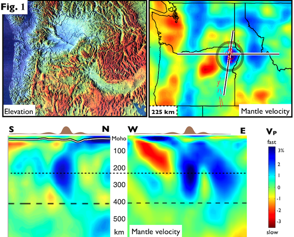
Upper left: topography, of the Pacific Northwest, centered on the location of the Columbia River Basalt (CRB) eruptions. Note circular bull’s eye uplift pattern near center (with Wallowa Mts at the center of the bull’s eye). Upper right: teleseismic P-weave tomographic image of same area (crust and uppermost mantle structure from Haiying Gao). Small red lines show the location of CRB and (to the south) Steens dikes. Lower panels: cross sections of tomography model, with schematic representation of topography at top.
Full-resolution graphics file in original format: 0132.tiff
As the most recent and accessible flood basalt event, the Columbia River Basalts (CRB), affords an opportunity to study these controversial eruptions. The CRB erupted far north of the Yellowstone hotspot track, are associated with the creation of an odd circular “bull’s eye” pattern of post-CRB uplift (see Figure) centered on the Wallowa Mountains, and are unique for being mostly basaltic andesite (which requires a large component sourced from melting a basalt-like rock). Our upper mantle imaging resolves a very fast structure ~100 km in diameter at 150-350 km depth, located below the topographic bull’s eye and the source area for the CRB (Figure). Careful imaging and resolution testing shows that this “Wallowa anomaly” is part of the larger high-velocity “curtain” imaged beneath central Idaho, attached to it as seen in Figure. The curtain is thought to be the dangling end of accreted Farallon ocean lithosphere, abandoned at the end of Laramide flat-slab subduction. Hence we think that the Wallowa anomaly also is part of the abandoned Farallon lithosphere. Because SE Washington and NE Oregon remained amagmatic following accretion (in strong contrast to all adjacent regions), it appears that the Farallon slab remained at the base of NA beneath this area (which was pre-accretion forearc) until CRB magmatism erupted 16 Ma. We infer that Farallon lithosphere at the base of NE Oregon foundered when the Yellowstone plume arrived beneath SE Oregon (associated with the ~16.7 Ma Steens flood basalts). Foundering rollback propagated to the north, driven by slab negative buoyancy and plume positive buoyancy, and enabled by basaltic intrusion between the Farallon slab and North America. Rollback pulled Yellowstone plume to the north, and the Farallon ocean crust provided the basaltic source required to make the basaltic andesites. The dense root of the 120 Ma Wallowa pluton was allowed to detach and fall, causing Wallowa Mountain uplift.
Acknoweldgements: Haiying Gao fro crust and uppermost mantle structure High Lava Plains experiment for use of their data IRIS for use of their broadband seismometers NSF Geophysics for funding our Wallowa seismic deployment
Keywords: tomography, columbia_river_basalt