


How Does Land Jump in an Earthquake?
This animation shows that GPS can record the movement of the leading edge of the overlying continental plate in a subduction zone. The plates are locked and the overlying plate is forced back. When friction is overcome and strain is released, the GPS receiver will snap back toward its original position. This animation is exaggerated to depict the relative motion of plates and GPS as seen in the 2010 Magnitude 8.8 earthquake in Chile where the land in places rebounded 10 meters.
CLOSED CAPTIONING: A .srt file is included with the downloiad. Use appropriate media player to utilize captioning.
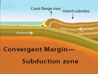
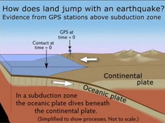
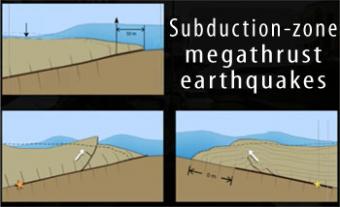
The subduction zone iswhere two tectonic (lithospheric) plates come together, one subducting (diving) beneath the other. The plates are locked together and periodically overcome the friction causing the leading edge of the overlying plate to surge back, lifting a wall of water producting a tsunami.
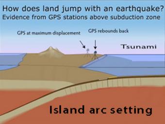
GPS records the movement of the leading edge of the overlying continental plate in a subduction zone. The plates are locked and the overlying plate is forced back. When friction is overcome and strain is released, the GPS receiver will snap back toward its original position.
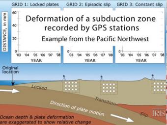
Subduction zones show that there are 3 distinct areas of movement in the overlying plate:
Subduction-zone megathrust earthquakes, the most powerful earthquakes in the world, can produce tsunamis through a variety of structures that are missed by simple models including: fault boundary rupture, deformation of overlying plate, splay faults and landslides. From a hazards viewpoint, it is critical to remember that tsunamis are multiple waves that often arrive on shore for many hours after the initial wave.


