


Ayla Heinze Fry
Ayla Heinze Fry is a student at University of Massachusetts at Amherst currently completing her research at University of Alaska, Fairbanks under Dr. Michael West.
Many don't really associate the two fields of glaciology and seismology, but in actuality, glaciers produce 'icequakes' within the glacier. Seismic stations in the ice and surrounding bedrock at Yahtse Glacier in southeastern Alaska have collected seismic data that I will be using. This summer I will be targeting the upper glacier icequakes not associated with calving of glaciers. I will be locating the origin of these icequakes, determining how frequently they occur, and comparing the seismic data with geological and meteorological data in order to better understand glacier movement and the influence of the surrounding environment.
AGU abstract Submitted!
August 11th, 2012
A followup on the statistical significance from earlier this week:
- A bunch of the groups didn't meet the criteria to test statistical significance of difference between waveforms occurring during night vs day.
- Those that did pass, I would claim that as a whole, most of the waveform groups do not pass a test of 90% certainty of if the time intervals vary. There are some that certainly show a difference, but most do not.
- We attempted looking at the waveforms of the groups that rejected the null hypothesis (that the night and day proportions were the same). Some of our waveforms definitely had similarities, but those were from stations that often do hold such similarities. Whether there were more during the night or day varied.
This week we also made a list of the last few scientific questions I need to tackle before I stop and work towards my ending presentation that ties it all together. Here the ideas, and the answers to the ones I've answered.
- Does the centroid of the auto locations move during the month of auto detections? ans: no
- Is there any difference in the locations between night and day? Or do the IQ epicenters occur in the same places, and in roughly the same proportions? No particulardifference in locations between night and day--epicenters generally appear in same cluster areas. Maybe just extended some b/c more during day........still working on proportions
- How do the strain rates vary temporally, and how do these compare with icequake event rates? A comparison with GPS velocity timeseries (Automatically detected IQ rate) diurnal and multi-week timescales. There are changes in strain rate patterns between Sept 24th and Oct 2nd, and comparison before and after that time period. Strange velocities seem to correspond with strange temps (?). Some velocity spikes post-oct 1st seem related to some event rates.
- At what distance are we no longer able to detect IQs?
- There's a period of strong "noise" (or is it signal?) that's recorded on all of the stations at some point in October. What the is it? Mike reports a move-out, and that it travels through the network. Basically, what's going on? It travels up glacier. Is it recorded also on the bedrock stations? What's happening with the weather?
- Don't notice trend with temp, wind--see weather_at_noise.png (note little pickup in rain)
-
Maybe something with precip --For other examples from the Sept 26th, see rain_at_noise.png, Sept26_rain_waves.png -
-
- Can we see it on bedrock: maybe at two, though they’re pretty noisy anyway, so hard to tell
- Can’t even necessarily see it on all the ice stations. It mostly shows up on line stations.
- I didn't notice anything suspicious with cross flow displacement or velocity. [except for that velocity is coming down from a strange high peak at the end of the strange time before then--as we saw in the figure with IQ event rate, temp and velocity.]
-


Basically where I've left myself right now is:
- I need to figure out at what distance we can no longer detect IQ.
- Maybe figure out why velocities are strange.
- Determine what cause of massive noise is, if possible.
- Figure out proportions of IQ occurence in area night vs day.
This weekend I'm headed down to McCarthy to an area of Alaska I haven't been to yet! Exciting! And it's a wonderful celebration with Tim and friends! Hooray!
2 weeks left, now. I'll get up some fun pictures soon, I hope.
Heavy Analysis
August 6th, 2012
This past week has been really busy actually analyzing my data, so it has been difficult to gather all of my thoughts to update the blog. Here are some of the hilights:
- Plots of all of the icequakes showed:
- icequakes in clusters and linear formations that appeared to have no relation to prior crevasses
-
areas of icequake concentration spaced evenly (this has been checked by looking at the lowest magnitude icequake and seeing if we can tell it is there on all stations. The pattern is not a detection bias just because the icequakes happen to be near the seismic stations. A question here is why they appear evenly spaced. One idea is to look into tensile forces.

- Spread of magnitude are as follows:

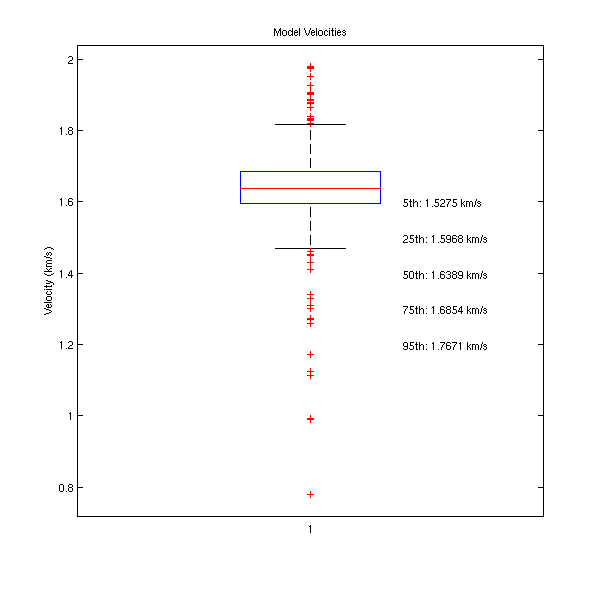
- We checked the velocity we'd been using by looking at moveout and picking a best fit, which gives us the velocity. A box plot of the velocities gave us some of the following results: ~1.64 km/s as 50th percentile, ~1.69 km/s as 75th percentile, and what we used as our model was 1.67 km/s, so pretty good I'd say!
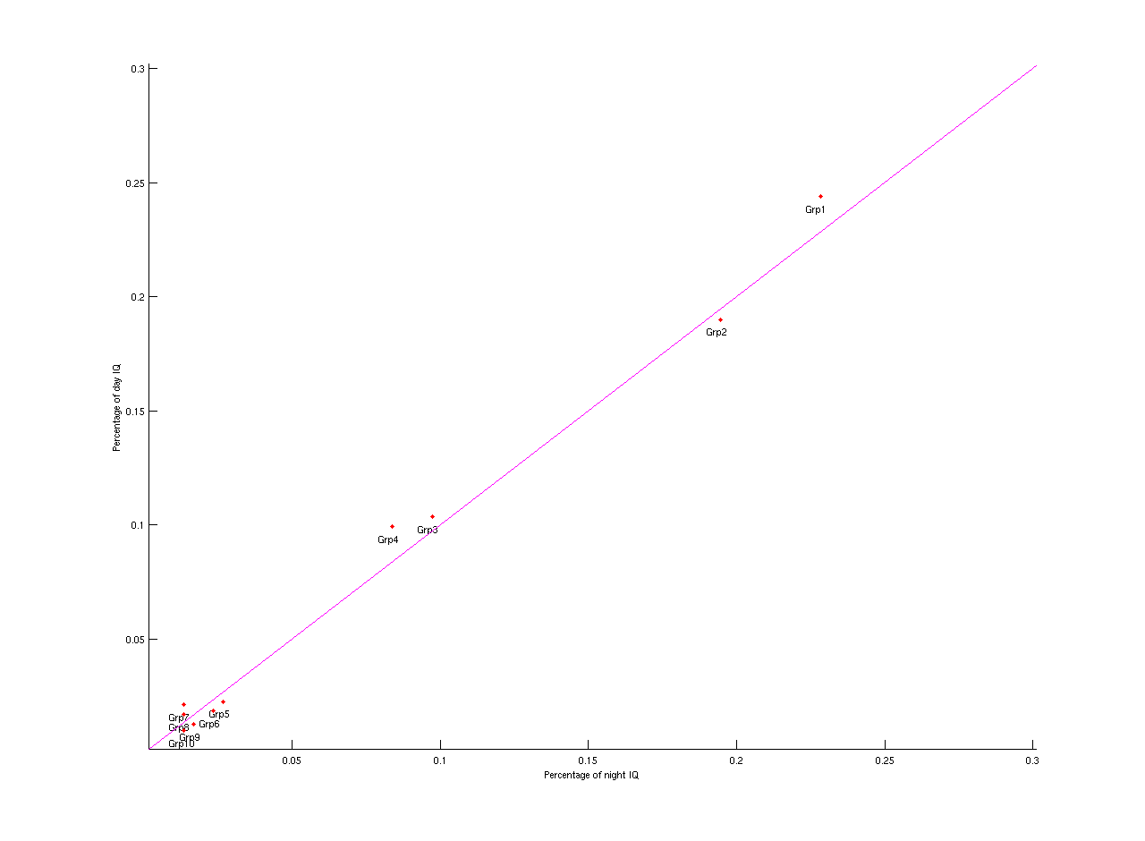
- I compared clustered waveforms (stacks of similar waveforms) over the night and day period. Making ratios to each cluster to the period (night or day) on a whole gives us a ratio, and we find that the relative percentages of the clusters to the whole are approximately the same for day and night (most of the time). Sometimes we see varying representations between night and day, but we still need to analyze for the significance (that's up on the plate as soon as the AGU abstract is up on its feet).
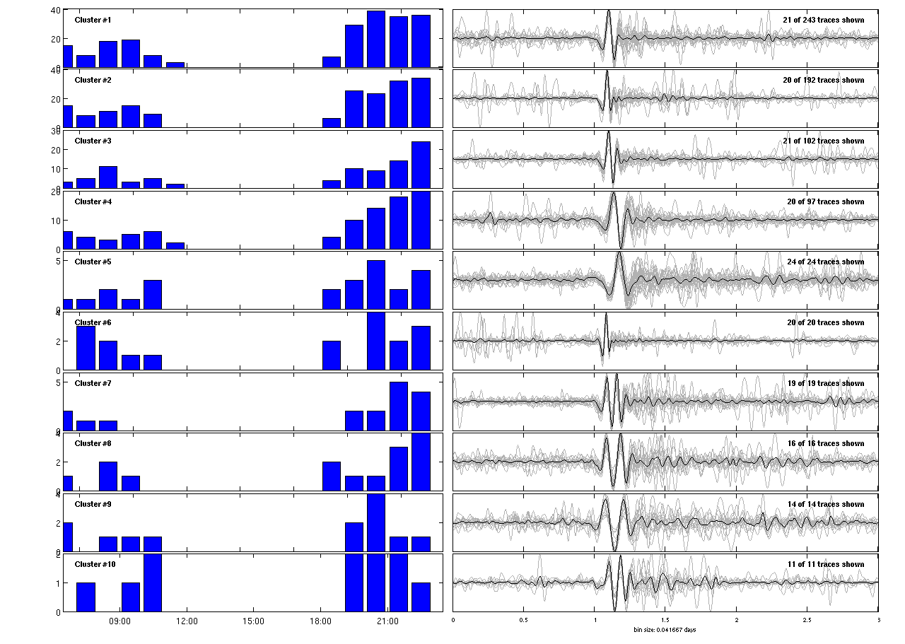
- I also worked on plotting waveform clusters on a map of the glacier to see if any waveform came from a particular area. Though there appeared to be some sort of patterns on occasion, I would say that there was nothing definitive. This turned out more challenging than anticipated, and I ran into coding problems. [note: dark blue--> red represents largest--smallest of top 4 waveform clusters]
With work from Mike and Tim, we've also been able to look at icequakes over a longer range of time, and they still appear in the same area.
The diurnal icequake rate signal also remains until early October when the seismic stations got covered by snow.

I would say it was a difficult week because I really wanted to work on my AGU abstract so I could go through more drafts, but I simply needed more information from the data I was gathering. It's really hard writing an abstract while you're finding out the results still! But from my experience and what I've heard of others' experiences, this is generally how it goes... Finally got a good draft though, I think!
I'll include figures when I'm at the office tomorrow.
Also...down to the last 3 weeks. Wow.
Week 8
July 26th, 2012
Since I last posted, I finished all of my picks for my second time frame, and I just finished all of the locations, which means I'm back to what I'll be doing with them and how I want to make comparisons. I've started reading up a bit again, and getting some more ideas of what types of patterns to look for in my data. I have at least one more article left on my 'to read' list... and I'm sure I'll find more.
I know I didn't have any figures last week, so I'll include the complete histogram of events I've picked once I figure out how to make it! (Mostly I still have some trouble figuring how to call information out of the database correctly...)
Also, my parents came up over the weekend to visit, and travel around the rest of Alaska. I went with them on the bus tours at Denali, and flightseeing up to Mount McKinley. It was amazing! I got to see an amazing display of crevasses, which is a significant portion of my project, so it was great to see it in person. When I get the histogram and my photos made/downloaded, then I'll post them up here!
Here's the histogram!

Week 7: Picks, Picks and more Picks!
July 20th, 2012
Well, sadly I don't have much to show for the work I've done over the past ~1.5-2 weeks, but I have been doing a lot! I've been making picks of icequakes for my second timeframe, and although I felt like there were fewer icequakes, my advisor showed me a histogram that was just representative of picks on 1 station, and boy was I wrong! Even when he produced the graph and I had an hour or hour and a half left of picks (out of 5 hours), I still had 3 times as many picks as I had in my last section! It's been a very pick-intensive last two weeks, and I'm almost at the point where I can locate all of them at once (which goes much faster generally). Only 9 minutes left of picking! But... for at least most of the rest of the day that's on hold because our system is being updated so I can't really get onto the computer. (Same thing happened with that histogram...our system update was under way so I couldn't get a hold of it first.) I'm in the library downstairs right now in order to write this.
So today I'll be working on catching up on some articles I've been meaning to read, and maybe starting to think about presentations and AGU abstracts and how to start those, even if I can't do all of it yet.
The Midway point
July 13th, 2012
Well, this week I officially reached my half way point for the internship. (half way through the week). Last week I reflected on some of my goals from the beginning, but now I'm going to reevaluate them and determine what old goals to keep and new ones to go on the list! So here are some things I've got:
- continue hiking and get out in the field maybe 1 more time
- continue to read more of the icequake literature to help me with my analysis that'll come up soon
- finish my second round of icequake picks (2 hours out of 5 down this week thus far, and I still have today!)
- continue to use matlab as a tool--this includes coming up with more good ways to compare my two time periods in a reasonable way
- presentation preparedness: I'm going to include my AGU abstract as well as the talk I'm giving here during my last week in this section
- figure out what I'm doing for my senior thesis
Some old things on my list that I've accomplished:
- learn more about glaciers and seismology
- use matlab as a tool
- use time-lapse photography for science
- field experience
- hiking
- getting to go to Alaska!
- Learing how to live on my own, not in a dorm
Now for some of my progress from this past week! I mentioned last time that I was going through and determining a new time period. I'll did pick a period and have started my picks for that time, and I'll show you how I got to that point! But first, I'll give you a couple of cool figures that helped wrap up my last time period.
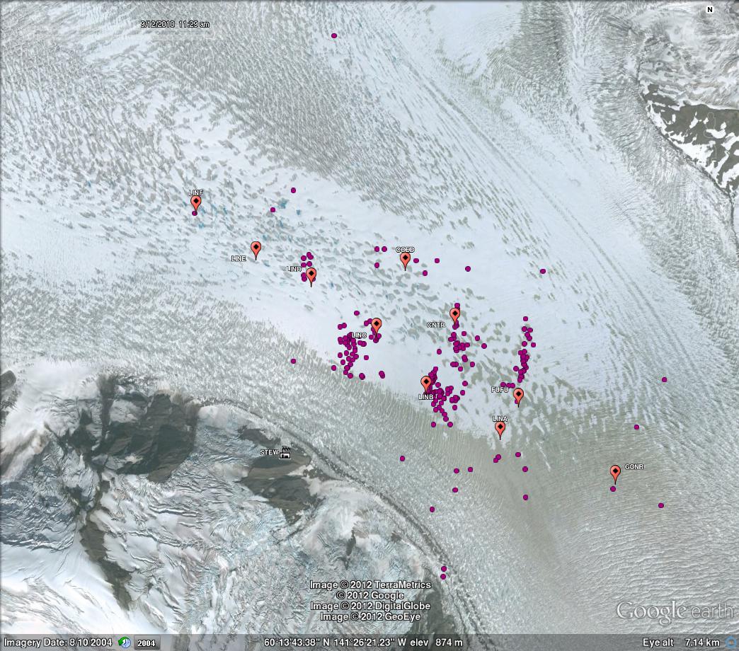
Here's all five hours (6:29-11:29 UTC, aka 10:29 pm-3:29 am AK time). The fuschia colored icequakes should be easier to see now!
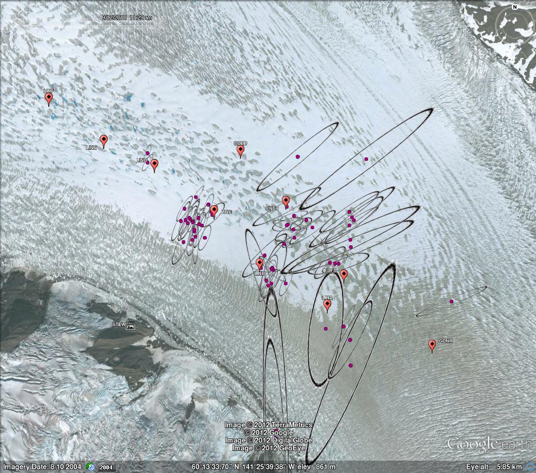
We then added some error ellipses, which can give you a headache if you look at all of them at once. (As you can see below). There are definitely some crazy ones, I'll admit, so that's why I'm going back and looking at those events to try to see what in earth is going on! But in the second figure below this one, I've chosen a shorter time period to look at so maybe we can actually understand the ellipses and their importance.
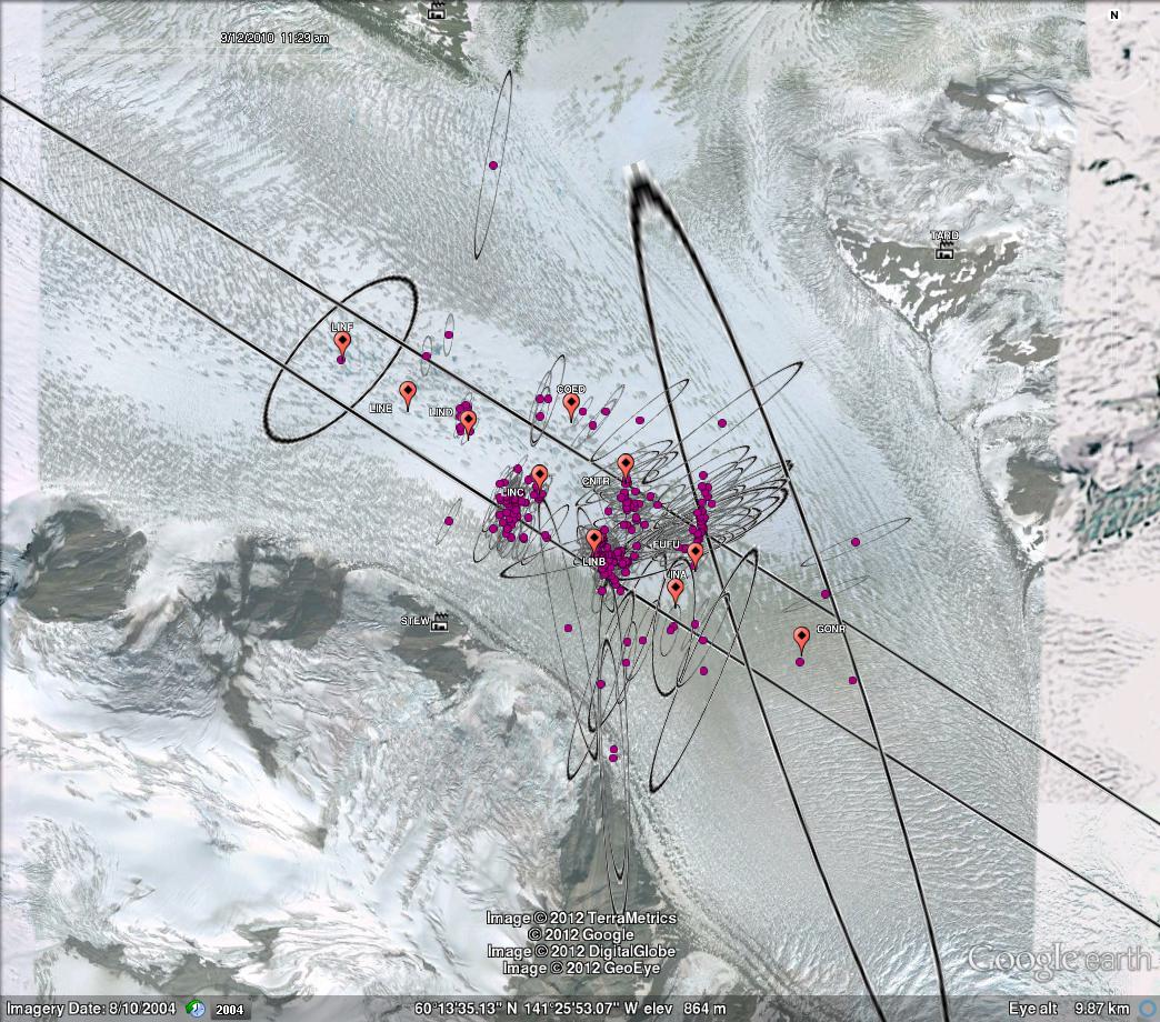
When we have a feature where the ellipses’ long axes are perpendicular to the feature, we are more convinced that it could be an actual feature. On the other hand, if the long axes of the ellipses are in parallel with the feature, it is harder to convince yourself that it is actually a feature, and you might conclude that it is possible all of the points occurred at one location. So if we look at the medium-sized ellipses stacked on one another on the right side, that linear alignment can actually be a feature. On the other hand, the tight cluster on the left where the ellipses line up with the feature, we find it less convincing the nature of that feature.
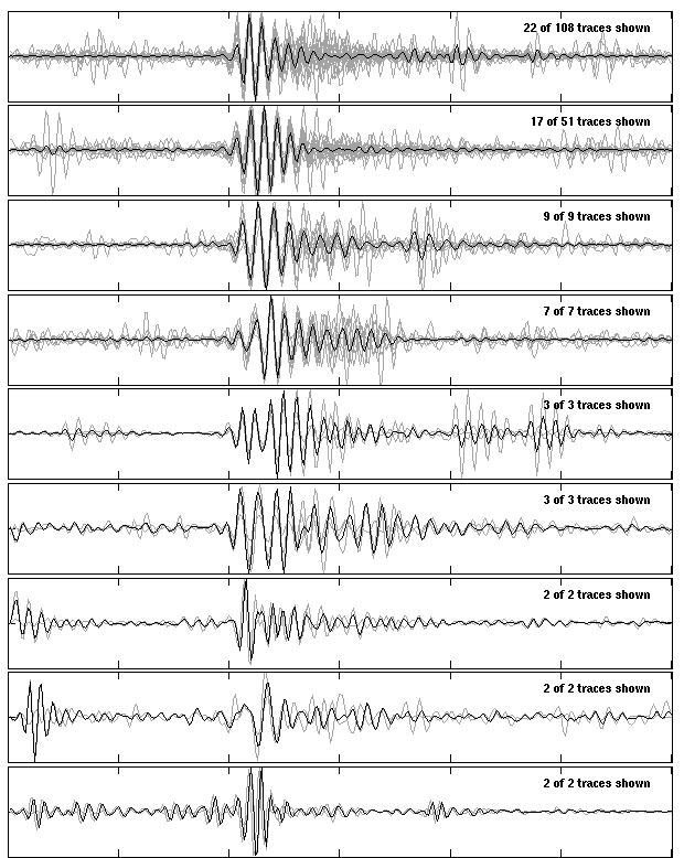
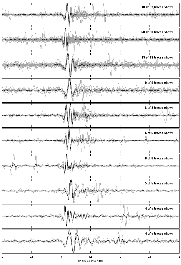
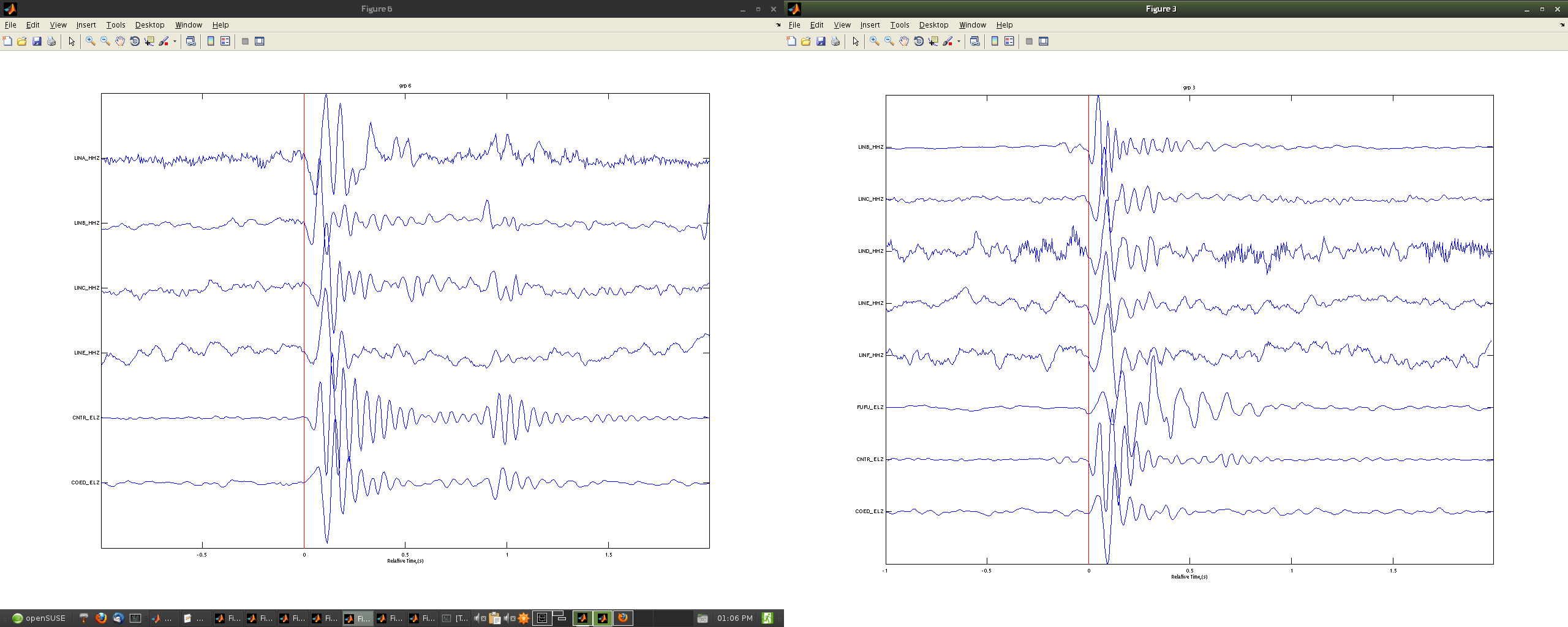
Also, we're starting to think about looking for patterns for automatic detection. Below I've just included some of the stacks, which pulled out just some of the most common patterns, and it tells you how many there are in that subgroup of similar waveforms. These stacks are looking at individual stations. On the left you have our station CNTR, while on the right is station LINC.
To find my new time, I started looking at the beginning of my first group, and started looking at my precipitation, temperature and wind for the week following. We therefore have a consistent amount of influence from preciptation (We have no precipitation during this time period). Our next idea was to look for sunny periods in the middle of the day for contrast, and preferably within a few days, so we narrowed down the search further. I calcualated some times that I would consider the middle of the day with the most sun cover. I determined to look at a time between 11 am and 4 pm AK time (19:00-00:00 UTC). The results narrowed down to a few days can be seen in the second set of graphs below. It has a few times marked off by colors on each end of the time period. The back markers represent our control period. The other colors represent potential time perods. Along the bottom of each graph, the format is: day, hour. I ended up looking at time-lapse videos over eachof those time periods to determine which time period had the clearest sky. The first one marked in magenta had very clear skies and therefore presents the best contrast to the control period.

.png)
I've made lots of progress with my picking in this time period, and will hopefully finish up the picks by mid week next week.
Until next time! Let me know if you have questions.
Week 5: Tying up one end for now, Part 2 emerges
July 9th, 2012
Since my last post was also a bit late, you heard some about my last week as well. I found better ways to look at some of my errors, and interpret the points that don't seem to match. I had record sections to look at arival times.
Most of what the second part of the week was doing was tying up my control group, which I revised to be a full 5 hours. I've been going through my old picks with my criteria of having an event with distinguishable waveforms on 6 stations. I've been taking note of when these criteria were not used, and I won't use them in my final analysis. I've also been filling in some gaps of time, and am nearly finished.
I've also been looking more closely for a new time to start picking. My control period was in the middle of the night, so when there is the least water delivery to the glacier (there was not precipitation or recent precipitation, it was cold so less melting influence from insolation). Talking with my advisors, we have decided to look at a time period that also did not have precipitation, but was sunny and in the middle of the day, and therefore having more water delivery due to melt. To make comparisons, I'll be doing picks for the same time duration (5 hours). I'll be looking for a time within a couple of days of my first set. I have glanced over some potential days but need to look at some of the photography and various other data to check for the best time.
I just went on my first trip to Denali. It was lots of fun. Really great weather in the first part of the day, and then it downpoured on us later. Also, if any of you know the book/movie "Into the Wild"...they moved the bus that Chris McCandless lived in to outside of this brewery about 10 miles away from the Denali Park Entrance. The original location of the bus, and where Chris lived his final days, was only about 15 miles away. It was errie in a way and just makes you think.
Reflecting a bit now on some of the goals from my first post:
- I've learned some more linux, but not as well as I'd initially intended. I've been too busy doing other things not specific to linux (aka, matlab)
- I can say I'm getting better at having academic conversations, between various social gatherings with grad students, and the conference here.
- I've gotten some experience in the field (and hopefully will get more). And now I am confident about being able to do other field work that comes my way.
- I've gotten in some better shape to some extent, though I'm still not really used to biking everywhere! I'm more used to walking... And I can say I've been out enough that I've enjoyed exploring some of the area
- I've been enjoying daylight, but I will be looking forward to nighttime! And if I'm lucky, I'll get to see the aurora at the end of the summer if it gets dark enough.
- Not much progress on next year or post-graduation yet... starting to think a little more about it now.
Check out last week's blog. It's been updated with pictures!
Until Next time.
Week 4: Multitasking
July 9th, 2012
July 3rd, 2012
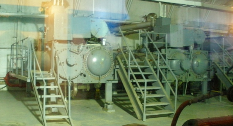
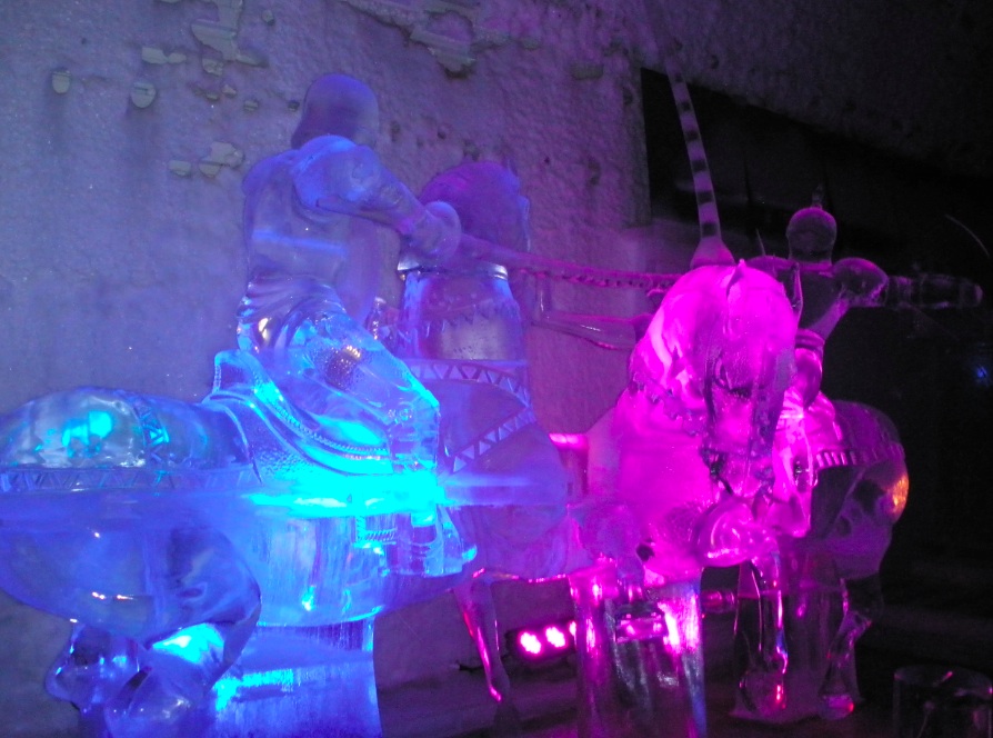
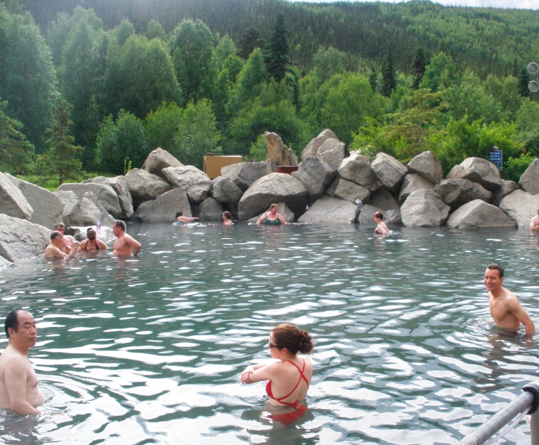
Last week was filled with multitasking because there was a glacial geology meeting (IGS) right on campus, so I was running back and forth between the geophysical institute and the conference, trying to take advantage of the conference--material, people and experiences--while it was here. I met lots of cool people from all over the world, and got to go explore out of Fairbanks once during the week. I got to go to Chena Hot Springs, which included going getting a tour of their geothermal plant, the greenhouse where they grow some of the food they serve, and the Ice Museum, which is actually cooled by energy from the geothermal plant (with energy from the hot spring!). I'll be sure to include photos soon.
I also made some more picks, which can be seen below (just about 5 hours worth of data now). Definitely good groups and clusters!
See below...
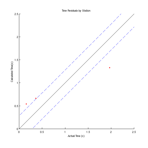
Based on Katie's comment from last week, I worked on code to find the events that seemed most out of norm (I picked looking outside of the blue dashed lines) with respect to time residuals. The red points in the right-most figure are the points that I would look into. What I've mostly concluded can be found in my second comment from last week's blog.

With help from the supportive community around me, I was also able to make some "record sections," which for those who don't know what they are, essentially plots along your axis relatively. For example, I was plotting my waveforms with actual time on the x axis and distance on the y axis. I thought I was a lot closer for a while than I actually was, so it took more time than expected. Basically, though, if we were to plot a line along the moveout, we would get the velocity at which the wave travels. What doesn't fall on a line might be due to the composition, or amount of air bubbles, structure, etc of the ice.
I also simply worked on some more ways to look at my data, just in case it'll be useful in further research.
Now that I almost have a good control group (goal spanning 6 hours), I'm starting to think more about my criteria for picks. Before I charge ahead with everything else, I have the following immediate goals:
- Determine a set criteria for my picks (e.g. at least 6 stations must show this signal clearly enough to pick)
- Go back through my control group to make sure all of my events meet the set of criteria
- Find the best way to go through temperature data I'm just now starting to look at.... and...
- Pick a variety of other times I want to look at in order to determine meteorological influences (i.e. picks times that are cooler and warmer and make further picks over those representative times). In other words, I'll be going over a more broad scope rather than just very nit-picky small timeframes
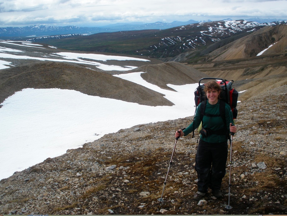
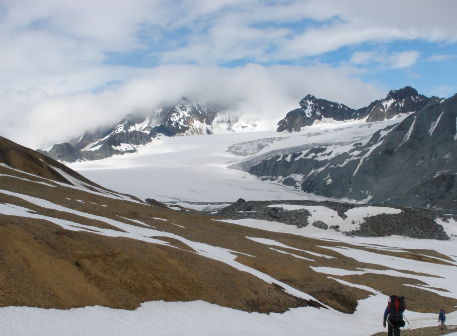
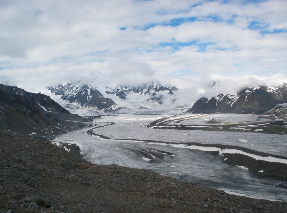
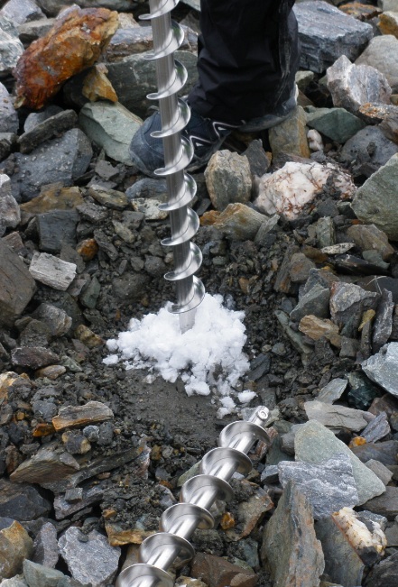
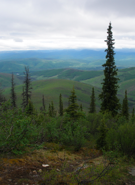
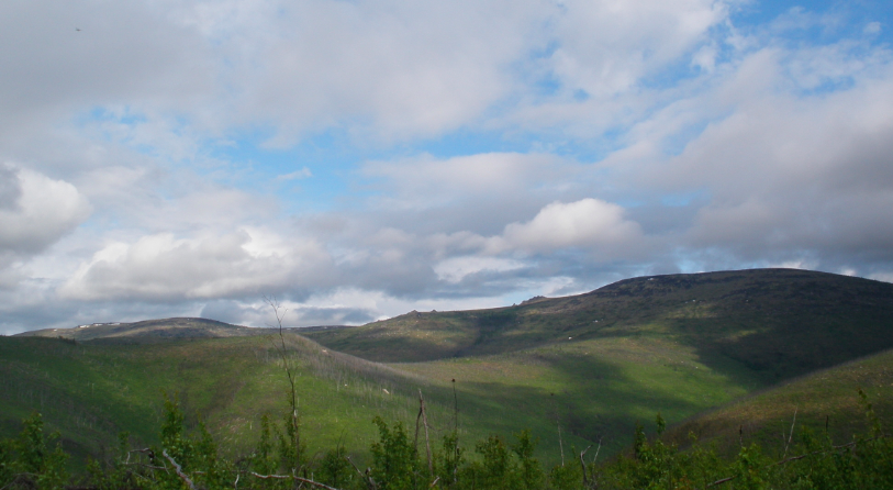
Also, this past weekend, I went out in the field with a glacial geology student to the alaska range. Backpacking 10 miles up through 2 passes, though snow, glacial quicksand muck and rivers, to reach the glacier, getting to hike and drill holes on the glacier and moraine, and backpacking back through everything. It was my first backpacking trip ever, second time on a glacier, first time hiking on a glacier, and my longest hike by the end of it. It was definitely an amazing experience! Photos to follow! (Also, that's why this post is late. Had short notice and needed to pack quickly when I'd been planning on doing this! Oops! 😊 )
Until next time!
(UPDATED: July 9th, 2012)
 A
A
A. Chena Hot Springs Geothermal operation
 B
B
B. Ice sculptures at the Ice Museum at Chena Hot Springs
 C
C
C. The actual hot springs
 D
D
D. My first backpacking trip, top of our second pass
 E
E
E. Decent into the valley we stayed in
 F
F
F. The glacier of our field excursion
 G
G
G. Drilling into morraine (and glacier, later)
 H
H
H. Checking out nearby crevasses
Week Three: Pulling things together, round 1
June 25th, 2012
The last week an a half have been really busy, and I've definitely been going through a large of what my project will be, but on a smaller scale.
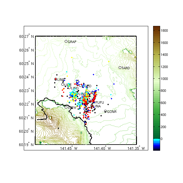
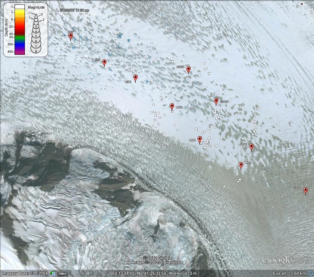
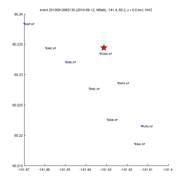
I've started to locate my icequakes using a program called dbloc2, which I can then load into a Google Earth file to see how they all plot along the glacier. We have assumed thus far that the icequakes are at the surface (in other words, most likely dealing with crevassing). This display of icequakes will continue to show more interesting results as I make more picks, but already I can tell that there clusterings around some particular areas (and this is with just 3 hours worth of seismic data). The image below is shows this three hour time period. All of the white dots are icequake locations. The labeled red points are seismic stations. There is a definite clustering of events around station LINB, and the beginning of one around COED.
.jpg)
I've also put in a lot of time working on quality control. As I was talking about last week, I was working on doing quality control on my own picks to make sure I was being consistent. Our location program also requires a velocity model, which needed to be changed from what is used for regular earthquakes, to what is needed for icequakes. In order to check to see if all the programs were running correctly and if the velocity model seemed to have approximately the correct velocity assigned, I made some graphs comparing residual times: the actual time it took to get from source to station vs the calculated time. I've also worked at tweaking this graph to pull out different points of interest to check quality based on other parameters. I've done so for station and seismic instrument type, latitude, and distance from the icequake origin. Some of the graphs can be seen below.
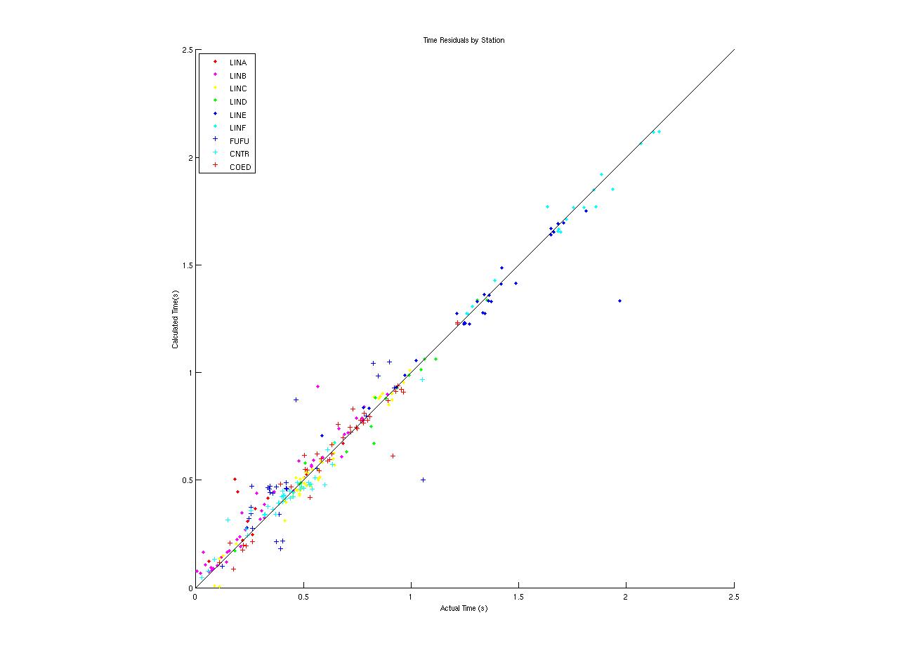
This figure shows that there are indeed some stations that seem to work better with the model, and those that have more spread. We can also see that there are definitely outliers. Generally speaking, though, this graph shows us that our model works well with our actual findings (we have a trend that follows actual=calculated).
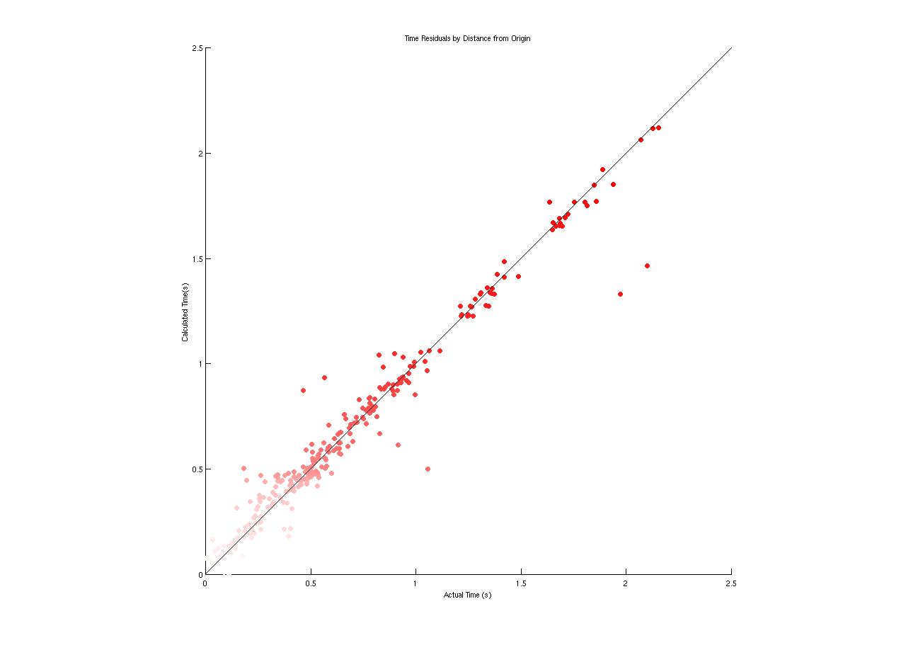

Figure on left (red): by distance from origin. Lighter reds are closer to the origin. Except for some outliers, stations further from the origin appear to have some less scatter, but this may be due to lesser amounts of data.
Figure on right (blue): by latitude. Lower latitudes are in lighter color. Higer latitudes seem to have less scatter generally, except for the occasional outlier.
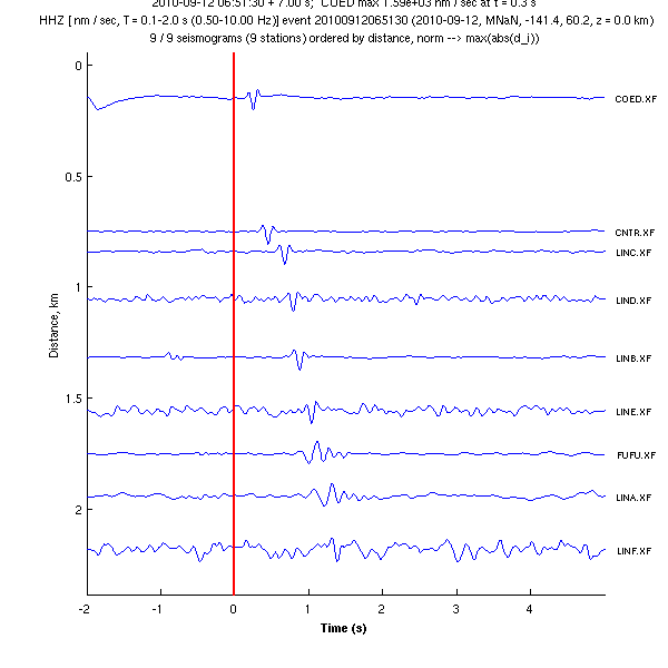
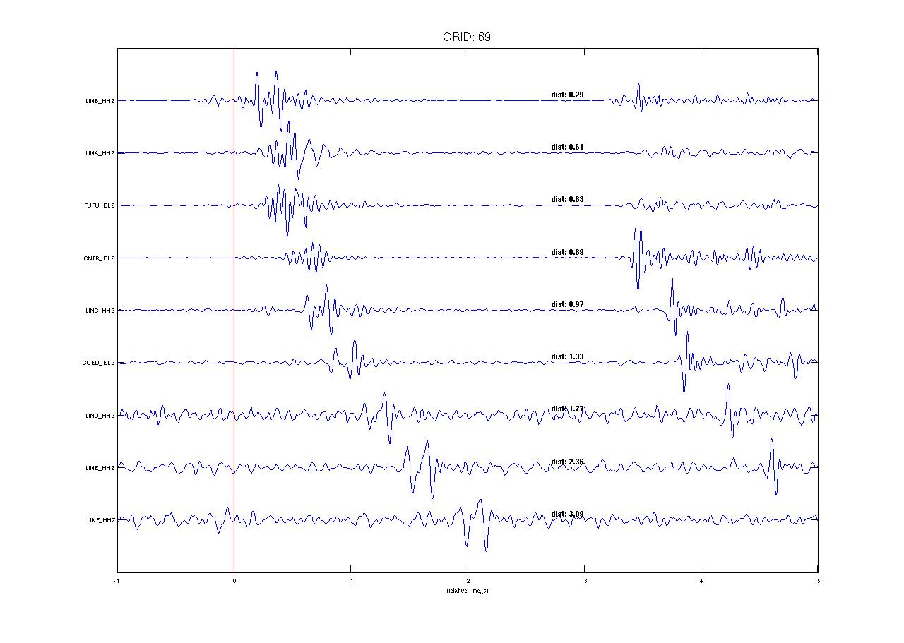
I have also been playing with other ways to look at waveforms, such as the varying pros and cons of hou to look at realtime waveforms. Looking at these ordered by distance from the origin has been a useful way to view these. An example of one of these graphs is shown below. The red line marks the time of the the actual event.
I also did a tutorial on datascope to try to better understand how the database is organized and how to work with it.
And I'm trying to compare waveforms on an intra-station basis to see if I can find a characteristic waveform. Thus far, I've found some stations have more characteristic waveforms than others, but I'm not convinced that they really have characterisic waveforms at a station. On the other hand, there are events that do seem to look really similar.
Otherwise, I was a bit sick last week when doing all of this--not too bad...and apparently not bad enough to stop me from going rock climbing last Thursday at the rock climbing wall on campus. But enough that this weekend, I decided it would be best to have a chill and easy weekend at home with LOTS of sleep. A bummer because I really wanted to go dancing with some of the people here, but I'm getting better, so looks like it was the right choice!
Until next time,
Ayla
Week Two: Starting up Matlab
June 14th, 2012
Here we are about 4/5 of the way through week two. This week has been mostly dedicated to learning ways to work with my data in MatLab.
On Monday afternoon, Tim introduced me to the script I'd be using and modifying for my own purposes. The icequakes I've picked are stored as a set of data 'w' and the script gives me multiple options for methods of operation on w. I ran into some challenges working with those, just because some didn't seem to do what I thought they implied. (For example, stack--it didn't work so well with my data because of different collection frequencies [100 vs 200 Hz] and thus different sample time lengths. It can be fixed, but for the time being, I don't need it.)
A meeting with Mike and Tim before Tim flew out for the next week helped specify and direct our goals for what to look at, and in what time frame.
My initial ideas were make/observe and record:
- correlation plots of the same IQ event
- correlation plots for the same station over multiple events
- arrival time delays (to figure out velocities, locations, etc.)
- frequency (to help determine a characteristic IQ from up-glacier)--A question I have is how to do this via calculation rather than visually looking at a spectrogram.
Based on those ideas, we made a short-term list of goals:
- Compare my picks for consistency of choices (to improve my picking strategy). This includes aligning my picks on a zero line and putting in a vertical line there and arranging the stations in a logical consistent order. (These are what you see in the images below- also shows what the icequakes may look like.)
- Determine dominant frequency patterns to define characteristic up-glacier icequakes.
- Continue to make more picks.
- Give a first shot at finding locations of icequakes (The code is still being worked on, so this hasn't been started yet.)
Hopefully today I'll be able to bike to get my groceries, go to Music in the Garden, and on Saturday, go out with Mike and his kids on the river for a day of fun!
I'm sure there will be pictures soon!
Ayla
Weekend Followup- Granite Tors
June 11th, 2012
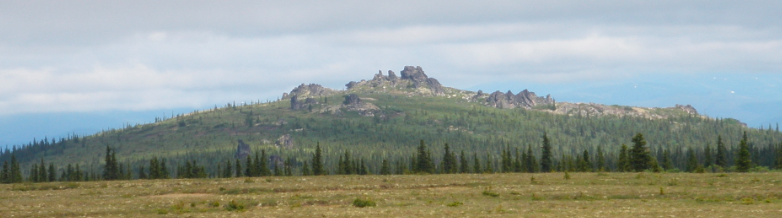
I just wanted to follow up with my first exploration. I went with a few of the glacial geology grad students to the Granite Tors hike on Saturday--about an hour from Fairbanks. It was a 15 mile hike, which I'm not fully in shape for yet, and thus hurt my knee some, but it's definitely doing a lot better two days later. I just wanted to share some photos from the hike.
~Ayla
Week One!
June 9th, 2012
Orientation at NM Tech was great, though extremely busy! But it paid off because we learned a lot, and I'm sure even more will come in handy as the summer progresses. Funny thing: my grad student advisor pulled out a copy of the Stein and Wysession book we got during orientation in order to explain some concepts, and so I got to bring in my own copy. That was fun! Still, though, even just being introduced to Linux during orientation was so useful, because that's all I'm using! The other interns are missed, but it's great to be able to follow their blogs and communicate with them as their own research develops!
Getting here to Alaska was a little bit rough, with a delayed flight from the NM orientation (as fellow intern Eva was describing), but I managed to get here Sunday night, in time to go to work the next morning. In additon to working with Michael West, I am working with a glacial geology grad student, Tim. He picked me up from the airport, and when I told him I still didn't quite believe I was actually in Fairbanks, Alaska, he was quick to point out the reindeer out the window. I'm living in a beautiful house with lots of windows upstairs (great for Alaska in summer), and currently borrowing a bike from a housemate currently on a trip. Once I find a spare tire, I have another bike I can use for the rest of the summer, assuming I'm tall enough to ride it!
Settling in at the office included an overarching tour of the building--at least a few of the floors, meeting basically everyone in the glaciology department and a bunch of people in seismology (more overlap than you'd think), and a lot of names! I've been reading and discussing some papers with Tim, who is very patient and a great teacher. Both Tim and Mike have helped a lot as I've started to look at the data in a program called SmartPick. Mostly though, I've been getting accustomed to Linux, learning how to identify different types of icequakes, and picking arrival times of different waves for my icequakes of interest. This will be used to feed information to the computer in order to automated process finding icequakes. Early next week I'll start bringing data into MatLab for some analysis fun!
Here are some goals I have for the summer:
- get familiar with linux (It's a must! I've gotten closer during these past two weeks!)
- figure out how different icequakes correspond to different factors (environmental, etc)
- become confident at holding a professional/academic conversation about my research with those who are far more experienced in the field
- get in great shape and see the land by biking to work, around town and exploring the surrounding area (First stop is the Granite Tors tomorrow--about an hour from Fairbanks)
- Look into a plan for after graduation next year (grad schools? time to start studying for the GRE? Oh boy!)
- try to get out in the field helping someone centered out of Fairbanks
- Enjoying the eternal sunlight (Yeah. It's 11 pm right now, and the lighting is maybe whaat it is at 5 or 6 back in MA).
With more to come,
Ayla