Amanda Livers-Douglas
Amanda Livers-Douglas is a student at Concordia College currently completing her research at Virginia Tech under Dr. John Hole.
For my internship this summer, I will be working with data from the Salton Seismic Imaging Project (SSIP) that was aquired in 2011. This entails the picking of first arrival travel times from several shots along a specific SSIP line in order to model and interpret geological structures through the use of velocity models. Also, I will be assisting in surveying seismometer sites for IDOR and the deployment of the seismometers in August.
Final Blog
September 2nd, 2012
My experience as an IRIS Intern this past summer was more exciting and beneficial than I could have ever imagined. I achieved many of the summer goals I set for myself and some of my long term goals as well.
The following is the progress I made on the goals I mentioned in my first blog.
• Explore all the different areas in Geophysics.
I now have expanded my knowledge of the field. Not only did I learn many things through talks with my host professor, but I took the time to meet with other professors as well. I met with a geomorphologist at Virginia Tech to learn more about his research. I also took advantage of the time I spent with all the different professors during IDOR. I learned about things like passive source seismology and all the different methods of near surface geophysics.
• Gain a better understanding of what area of Geophysics I might want to pursue in graduate school.
After learning about all the different areas of Geophysics, I am most interested in near surface geophysics. Knowing this I am continuing to expand my understanding of this area in order to decide exactly what I will pursue.
• Learn how to make a professional scientific poster.
Due to my limited time working on SSIP, I only had enough time to finish my data processing before I had to leave for IDOR. Therefore, I did not have time to start a poster. This semester I will be taking a couple of workshops on poster presentations to help reach this goal.
• Become familiar with a variety of computer programs and software used in Geophysics research.
This summer I definitely became familiar with several different types of software. The two I became most familiar with were MatLab and SeisSpace.
• Expand my knowledge of writing code and understanding scripts.
I wish I would have had more time to spend with writing code this summer. I did spend quite a bit of times learning how to read the scripts I was using to run my tomography model and modifying them slightly. I look forward to my next coding opportunity.
• Be able to branch out and explore new places and new cultures and meet new people while doing this.
I went to several town festival while in Blacksburg, VA and even had the chance to hop on a bus to Christiansburg, VA and explore the town. I met a great group of people in Virginia and met even more during my time in Idaho.
My experience overall was more than I could have ever asked for.
I ended my experience off on a high note. After proposing IDOR Gives Back, which was an idea to donate all the unwanted blankets and pillows used during IDOR, I got to deliver all the items to a shelter in Boise, ID on my way to the airport.
Now that it is over, I can't wait to continue finalizing my presentation for the AGU Fall Meeting.
I am so grateful to have been an IRIS Intern. This summer I not only grew as a student and researcher, but as a person as well.
Goodbye,
Sincerely,
Amanda
Week 9 and Week 10
August 27th, 2012
Week 9 consisted of going out and picking up all the seismometers we deployed the previous week. It seemed like a giant treasure. For three straight days we went out with GPS in hand to locate the sights of the seismometers. We had to locate the exact burial location a the sights by searching for clues such as a mound of dirt, an out of place rock, or an oddly positioned twig. Then in an attempt to not damage the equipment we dug up the seismometers by hand. We then shined up our newly found treasure and put it in our treasure chest as shown below.
The photo above shows Texans laying in a protective case after pick-up.
All the deployed instruments made it back from the field. None were lost or taken by the wildfires on the east end of the line near Stanley, Idaho. All the volunteers also made it back from the field in good spirits. Many with fun stories to tell about their adventures.
My fun story took place on the second day of pick-up. My partner for the day was Dr. Ray Russo from the University of Florida. He and his crew have over 80 operating broadband stations throughout Idaho as part of IDOR. I was lucky enough to visit two stations with him that day. After deploying a similar station during the IRIS Intern Orientation in New Mexico, I was thrilled to visit one in the field.

The photo above shows a broadband station near Midvale, Idaho.
The last few days of IDOR were spent washing all the dirt off the insides and outsides of the 20 plus vehicles and cleaning up the remaining equipment.
I thoroughly enjoyed my time working on IDOR and I am excited to see the final products of the project.
Stay tuned for my final blog.
Goodbye for now.
Sincerely,
Amanda
Week 7 and Week 8
August 14th, 2012
Week seven was my final week at Virginia Tech. I spent my time finalizing my tomography model and learning how to interpret it. My model shows several geological structures highlighted below in Figure 1 and Figure 2.
.jpg)
Figure 1: The black stars on the model above show the location of three ranges. (left to right: Coyote Mountains, Superstition Mountain, and Chocolate Mountains) The seismic velocity through these ranges reaches a faster speed near the surface than in the valley between Superstition Mountain and the Chocolate Mountains. The circled area in the valley shows a shallow basement, which corresponds to the active geothermal Brawley Seismic Zone.
.jpg)
Figure 2: The grey arrows point towards two faults on either side of the valley. The approximate location of the faults are located by black lines. The sharp change in the seismic velocity gradient indicate the location of the faults.
With these interpretations, I wrote and submitted my abstract to AGU for the fall meeting. Throughout the next couple of months I will be fine tuning my final interpretations to create a poster presentation for the meeting.
Week eight was spent in Idaho helping with IDOR. I arrived two days before the forty plus IDOR volunteers to prepare for their arrival and obtain equipment needed for the deployment of the 2,500 seismometers.
By Wednesday morning all the volunteers and PASSCAL employees arrived for training. Volunteers came from several different states and four different countries to deploy seismometers. I joined them during training, where we learned the proper technique to deploy the seismometers and navigate using Garmin GPS devices.
On Friday, we were sent out in pairs to deploy up to 50 seismometers across the seismic line at locations I helped survey in July. Saturday I joined a crew of three other volunteers on a four mile back-pack hike through Idaho National Forest to deploy twenty seismometers. On Sunday, the final seismometer was in the ground.
To celebrate a successful deployment we went on a geology field trip where we learned what other research was being done in the area. The day ended with observing one of the shots being set off and watching a meteor shower.
Stay tuned next week to hear how the rest of field work went.
Goodbye for now.
Sincerely,
Amanda
Week 6
July 30th, 2012
After finishing up surveying for IDOR on Sunday, Monday was spent cleaning the vehicles and doing last minute tire repairs. Then it was back to Virginia on Tuesday.
The first day back at Virginia Tech, Wednesday, was full of data processing for SSIP. I spent the day sorting the first arrival time picks. The purpose of this sorting was to take the 100m spaced receivers in the valley and to choose every third receiver in order to have spacing in the valley that is similar to the spacing of receivers outside the valley.
Then on Thursday I used the newly sorted picks to create another tomography model. This model along with the previous model were fine tuned on Friday. The resulting models ,shown below, will be used to interpret the subsurface geology of the Salton Trough.
The models are grouped based on the parameters used and whether the picks were sorted or not sorted. The groups are organized even further by smallest to largest iteration number. Iteration number is the number of times the tomography script produced a new model every third time using different smoothing.

The tomography models above are of non-sorted picks.
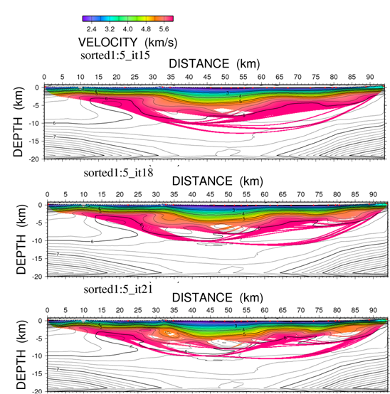
The tomography models above are of sorted picks.
Stay tuned next week for my analysis of these models.
Goodbye for now.
Sincerely,
Amanda
Week 5
July 26th, 2012
This week was our second week in Idaho and Oregon surveying sights for IDOR. The majority of our week was spent in the beautiful Idaho National Forests, which was home to a diverse group of wildlife and several geological structures.
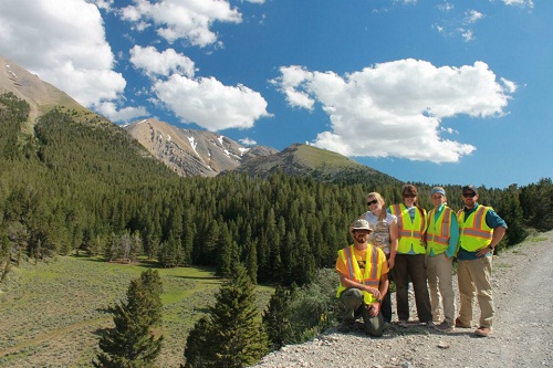
The photo above shows part of the survey crew in Challis National Forest.
Throughout the week, the group got to visit a seven foot high fault scarp, natural hot springs, Craters of the Moon National Park, and an old copper mine. The following pictures show some of the things we got to see.
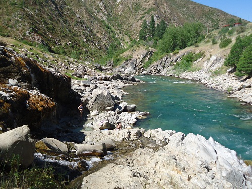
The photo above shows a natural hot spring pooling up on the left banks of a river.
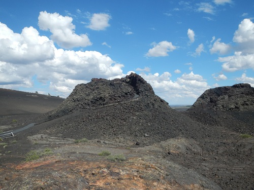
The photo above shows a few splatter cones in Craters of the Moon National Park.
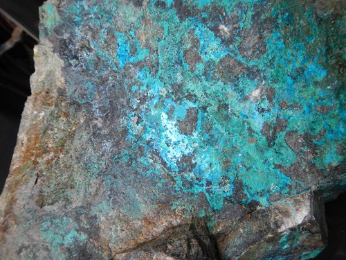
The photo above shows a rock collected at an old copper mine near Mackey, Idaho.
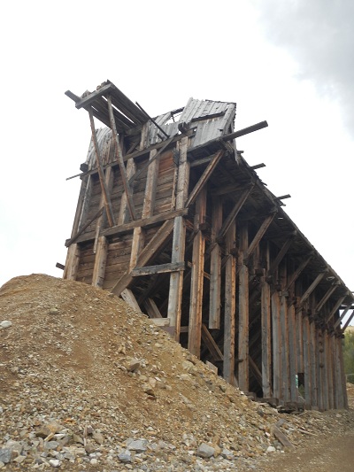
The photo above shows an old mining building at the same copper mine.
Although the trees and mountains were not conducive to the GPS locating satellites, it was fun to work in that environment. In the forest the group saw several varieties of gophers, a black bear cub, mountain goats, elk, deer and antelope while working.
We successfully finished surveying the almost 3,000 sights on Sunday, July 22. Our final total of flat tires came out to be ten. The final total of different hotels we stayed in came out to be seven. The final total of laughs and smiles came out to be too large to count.
I look forward to returning in August to deploy the seismometers to our surveyed sights.
Stay tuned next week to hear about my time back at Virginia Tech working on SSIP data.
Goodbye for now.
Sincerely,
Amanda
Week 4
July 16th, 2012
This past week I have been out in the wilderness of Oregon and Idaho enjoying the outdoors while working on the IDOR project. The aim of this project is to use active source seismology to gather data that will be used to create a tomography model . This model will be used to understand the different layers in the Earth's crust and other geological features. This is similar to what I am doing with the SSIP data from line three.
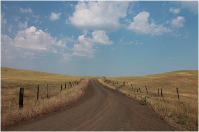
The picture above is part of the line in Idaho.
I am working with a crew of eight students ranging from graduate students to undergraduates from all over the country. Each day we split into teams of two and survey a portion of the IDOR line. (Unlike SSIP that had multiple lines, IDOR consists of one long line) When surveying we locate predetermined sites with a Garmin (GPS) and pick a suitable area for a seismometer to be buried. We then label the spot with a numbered wooden stake and record the location using a Trimble (GPS). In August, the deployment team will locate our stakes and set up the appropriate seismometer.
.png)
The picture above shows the four survey vehicles.
Each day has been an adventure. Our goal is about one hundred stakes per team per day, so our pace is often fast. However there has been many twists and turns along the way. The crew has experienced three flat tires, a rattle snake, and a black bear. Thankfully we have all made it out safe and now know how to replace a flat tire in less than ten minutes.
Besides picking up useful tire changing skills, we have had the opportunity to explore the local geology. We have been able to climb on outcrops and have even seen several igneous dikes. So far the team has collected several pounds of igneous and metamorphic rocks from these outcrops. This collection includes several pieces of obsidian.
This leads me to my next topic. Flint knapping!!! I have been trained in flint knapping, so I felt it was a great opportunity to share my knowledge with some of my fellow crew people. Without handmade tools, we had to use a rock as a tool. I was not successful in passing my skills along, but I was able to make a few little arrow heads.
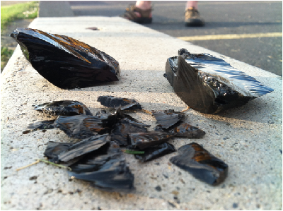
The picture above shows some of the larger pieces of obsidian before they were thinned and a pile of flakes already taken off.

The picture above shows some of the worked on pieces.

The picture above shows my most successful attempt at an arrow head without using handmade tools.
This has been a fun week full of hands on field work and hands on geology lessons from the other crew members that have geology degrees. I have been really grateful for all the geology knowledge I have been exposed to because my Physics coursework has not allowed me much time for geology courses.
Stay tuned next week to find out what wild animals have crossed my path and what new geologic features I have explored.
Goodbye for now.
Sincerely,
Amanda
Week Three
July 12th, 2012
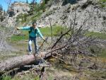
Over the weekend of June 30th Virginia was hit with several severe storms and tornadoes that wiped out power lines, cell phone towers and trees like the one pictured below. Blacksburg was lucky for the most part. Only one section of the town lost power and it was restored relatively quickly compared to the surrounding areas that are still without power.

Pictured above is a pine tree near Virginia Tech campus that fell down during high wind storms.
We were fortunate enough to have power on Monday in time for work, so there were no delays in data processing. This was important because my week was spent trying to fine tune my tomography model before we had to leave for Idaho to work on the IDOR project.
The first part of my week was spent developing a velocity model based on line three data. This was used to replace the velocity model that was based on line one data, which was used in my first tomography model. This was done in order to produce a more accurate tomography model.
After the velocity model was created, I worked on changing the ratio of x and y position components.Then a new tomography model was created for each change in made to the ratio. This process is only in the beggining phases and will take up the remainder of the time I have to work on the SSIP project.
As of Friday afternoon, it was officially time for me to start working with Rachel on IDOR. Friday we had specialized training in order to be able to successfully use Trimble gps units in the field. We will be using the Trimble over the next three weeks in Idaho. In Idaho we will be surveying station sights for the deployment of seismometers in August.
Before heading to the airport to leave for Idaho, I got to go on a hike to the Cascades. The Cascades ,pictured below, are an amazing set of waterfalls located near Pembrock, Virginia. The hike was a wonderful four mile hike in the shade of the trees on a hundred degree day.
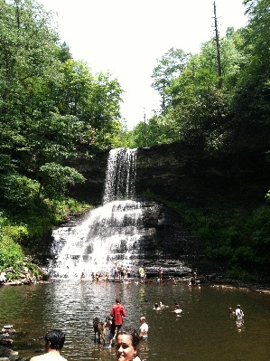
My week was extremely pleasant at work and during my free time.
I am excited for the upcoming weeks that will be spent in Idaho.
Tune in next week to hear all about field work in Idaho.
Goodbye for now.
Sincerely,
Amanda
Week Two
July 3rd, 2012
This past weekend in Blacksburg was a blast. Saturday morning I wandered the local farmer's market and stopped to enjoy a local bluegrass band play. Also, on Saturday there was a summer solstice festival that included clothes and craft vendors, a dog parade, and live music all day.
On Monday it was back to data processing. After calculations to check for reciprocity, the first arrival time picks were redone in order to reduce the error in our reciprocity. The following picture shows the first arrival times picks for shot 30480, which is located in a valley along line three.
.jpg)
Figure 1: First Arrival Times for shot 30480. The y-axis is time measured in millisecond and the x-axis is the station identification. The first arrival time picks are shown in red.
After the picks were improved and reciprocity was rechecked the data was then used to create a tomography model. This was done using scripts that had previously been made. The parameters of the code were recalculated to fit our specific data. Using the data, input files were made. After running the program the following tomography model was created.
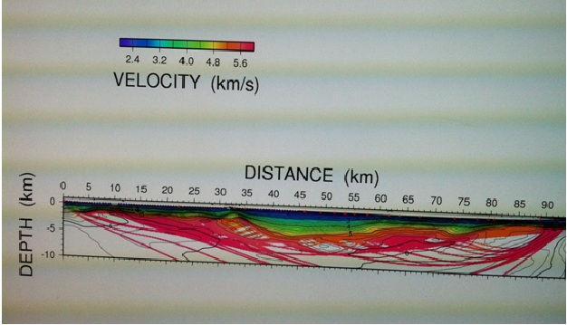
Figure 2: Tomography model of the SSIP line three. The y-axis shows depth in kilometers and the x-axis shows distance in kilometers where the zero is set at the western most shot on line three.
The next step is to go back and adjust parameters in the scripts and in the initial velocity model. This is done in order to double check that the features in the tomography model are accurate and not the outcome of specific code parameters.
Tune in next week for an update on finalizing the tomography model.
Goodbye for now.
Sincerely,
Amanda
Week 1
June 24th, 2012
My internship started out with a wonderful week of orientation at New Mexico Tech in Socorro, New Mexico. I met a fantastic group of people that share my love for the geosciences. It was great to be able to learn from not only the presenters, but my fellow interns! I learned so many things about the geosciences, graduate school, and possible career paths in geophysics through our hikes, classroom sections, and talking one-on-one with presenters and other interns. Not only do I have a better understanding of the research techniques I will be using this summer, but a better understanding of what goals I want to accomplish this summer.
These goals include the following:
Explore all the different areas in Geophysics.
Gain a better understanding of what area of Geophysics I might want to pursue in graduate school.
Learn how to make a professional scientific poster.
Become familiar with a variety of computer programs and software used in Geophysics research.
Expand my knowledge of writing code and understanding scripts.
Be able to branch out and explore new places and new cultures and meet new people while doing this.
This first week at Virginia Tech in Blacksburg, VA has been a very productive one in terms of striving to achieve my goals. I have been exploring the town, becoming acquainted with my coworkers, and started learning more about my project.
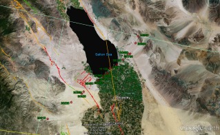
Dr. Hole briefed my fellow intern, Rachel Petit, and myself on the work we will be doing this summer on the SSIP and IDOR projects. After that it was straight to work processing data. The first step in processing this seismic data has been to pick first arrival times of shots along line three of the SSIP. (The following picture shows the shots as red stars along line three south of the Salton Sea.)
Several shots were picked by Rachel and myself and combined with shots along the same line that had previously been picked. These picks were exported and calculations are underway to check the reciprocity of the picks.
So far I have enjoyed working with the data and am looking forward to being able to use the data to produce a tomography model in the weeks to follow.
The week ended with a lovely barbeque with Dr. Hole's family and all the graduate students that will be joining us for the IDOR project.
Tune in next week for a summary of the weekend happenings in Blacksburg, pictures of the first arrival time picks, and the progress being made on the SSIP data.
Goodbye for now.
Sincerely,
Amanda


