


Intermediate Spanish
How do scientists know which direction the fault moved deep underground?
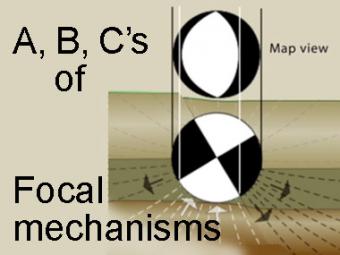
When an earthquake occurs, seismologists create graphics of focal mechanisms, informally referred to as beach balls,to show the faulting motions that produce the earthquake. They use the patterns of compressions and dilatations received by seismometers. Simply put, the focal mechanisms are based on the direction of the first arriving P wave. This is a difficult concept for many, but this animation walks viewer through steps to understand how scientists know what kind of fault motion occurred deep underground. The different faulting mechanisms for each focal-mechanism end member includes: strike-slip fault, normal fault, and thrust fault.
GIFs for select segments of the animation available as optional download.
CLOSED CAPTIONING: A .srt file is included with the downloiad. Use appropriate media player to utilize captioning.
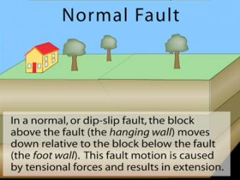
In a normal fault, the block above the fault moves down relative to the block below the fault. This fault motion is caused by extensional forces and results in extension. Other names: normal-slip fault, tensional fault or gravity fault. Examples: Sierra Nevada/Owens Valley; Basin & Range faults.
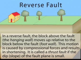
In a reverse fault, the block above the fault moves up relative to the block below the fault. This fault motion is caused by compressional forces and results in shortening. A reverse fault is called a thrust fault if the dip of the fault plane is small. Other names: thrust fault, reverse-slip fault or compressional fault]. Examples: Rocky Mountains, Himalayas.
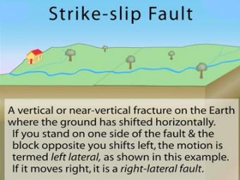
In a strike-slip fault, the movement of blocks along a fault is horizontal. The fault motion of a strike-slip fault is caused by shearing forces. Other names: transcurrent fault, lateral fault, tear fault or wrench fault. Examples: San Andreas Fault, California; Anatolian Fault, Turkey.
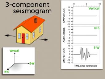
We use exaggerated motion of a building (seismic station) to show how the ground moves during an earthquake, and why it is important to measure seismic waves using 3 components: vertical, N-S, and E-W. Before showing an actual distant earthquake, we break down the three axes of movement to clarify the 3 seismograms.
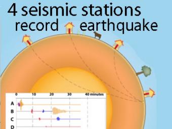
A cow and a tree in this narrated cartoon for fun and to emphasize that seismic waves traveling away from an earthquake occur everywhere, not just at seismic stations A, B, C, and D. A person would feel a large earthquake only at station A near the epicenter. Stations B, C, D, and the cow are too far from the earthquake to feel the seismic waves though sensitive equipment records their arrival.
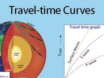
A travel time curve is a graph of the time that it takes for seismic waves to travel from the epicenter of an earthquake to the hundreds of seismograph stations around the world. The arrival times of P, S, and surface waves are shown to be predictable. This animates an IRIS poster linked with the animation.
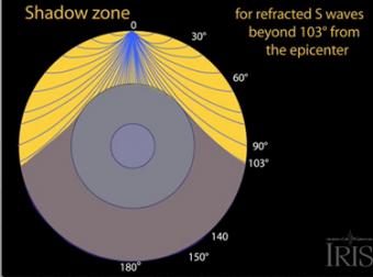
The shadow zone results from S waves being stopped entirely by the liquid core. Three different S-wave phases show how the initial S wave is stopped (damped), or how it changes when encountering boundaries in the Earth.
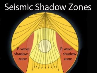
Seismic shadow zones have taught us much about the inside of the earth. This shows how P waves travel through solids and liquids, but S waves are stopped by the liquid outer core.
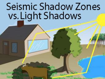
The wave properties of light are used as an analogy to help us understand seismic-wave behavior.
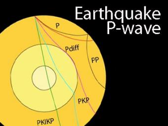
The shadow zone is the area of the earth from angular distances of 104 to 140 degrees from a given earthquake that does not receive any direct P waves. The different phases show how the initial P wave changes when encountering boundaries in the Earth.
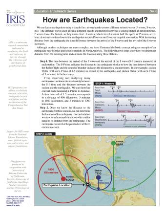
Knowing precisely where an earthquake occurred is an important piece of scientific information. It can help seismologists identify and map seismic hazards. It is also a fundamental piece of information necessary for facilitating studies of Earth's internal structures. This fact sheet provides an overview of the S-P process to locate an earthquake.
NOTE: Out of stock; self-printing only.

When the Crandall Canyon Mine collapsed on August 6, 2007, questions arose about the causes of the deadly accident. This fact sheet explains how seismologists analyzed data recorded by USArray seismometers to determine if an earthquake caused the mine to collapse.


