
By Alka Tripathy-Lang and Wendy Bohon
On January 28th, 2020, beneath pristine Caribbean waters, a magnitude-7.7 strike-slip earthquake ruptured the Oriente fault that separates Jamaica and Cuba. This transform fault splits spreading centers—where new oceanic plate forms—from one another. Scientists typically frame these near-vertical crustal-scale gashes as simple planar features.
As the 2020 earthquake tore through the crust, far-off seismic stations measured signals produced throughout the event. During the first 40 second of the fault breaking, or rupturing, stations located at similar direction and distance detected similar patterns of seismicity (Figure 1). However, between 60 and 80 seconds, the signal shapes became distinct, which is not expected if the rupture broke a single surface. This observation suggested to scientists at University of Tsukuba, led by graduate student Tira Tadapansawut, that both the geometry of the rupture and transform fault were complex.
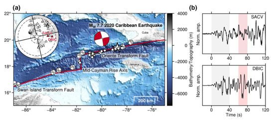
Figure 1. A. Bathymetric map of the study area showing the relevant transform faults and their orientations. The focal mechanism (beachball diagram) for the magnitude-7.7 earthquake is in red and focal mechanisms for other earthquakes greater than magnitude-6 are shown in grey. B. Seismic waveforms at stations SACV and DBIC. The locations of these station are shown as red triangles on the inset world map. The areas shaded grey and red are, respectively, highlighting regions of similarity and difference in the waveform shapes.
In this inverse problem, scientists have a set of observations, namely seismic data from stations around the world, including 152 Global Seismographic Network stations. Their goal is to determine what caused their observations, which in this case includes the geometry of the fault and how the rupture propagated.
To explore these aspects of the earthquake, Tadapansawut and colleagues modeled the fault by defining an east-northeast-striking, 460-kilometer-long vertical plane that extended to a depth of 25 kilometers. In the model, they subdivided the modeled fault surface into 20 kilometer-long and 5 kilometer-wide sub-faults, beginning 320 kilometers west of the epicenter as determined by the U.S. Geological Survey, and ending 120 kilometers to the east.
In many studies of transform fault earthquakes, the fault geometry is often assumed to be a linear feature, said Ryo Okuwaki, coauthor and professor at the University of Tsukuba. By allowing variation of each sub-fault’s geometry following the method of Shimizu et al. (2020), the geometry of the overall fault is subsequently solved as the observed data requires, he explained. “We can explore possible geometric complexities of the Oriente transform fault, which was previously thought to be as simple as a straight line.”
An advantage of the Shimizu et al. (2020) method used in the current study, says Yuji Yagi, also a study coauthor and professor at the University of Tsukuba, is that because the geometry of each sub-fault needs not correspond to the defined model plane, the modeling error associated with defining a simplified fault plane decreases.
The authors assumed slip began at the epicenter and proceeded for 100 seconds, with a maximum rupture velocity of 6.0 kilometers per second—supershear speed. In other words, they allowed the rupture to proceed breathtakingly fast— faster than the speed of S-waves. Supershear is often observed in strike-slip earthquakes, like the 2018 Palu, Indonesia earthquake (Bao et al., 2019; Okuwaki et al., 2020) and the 2016 Romanche earthquake (Hicks et al., 2020), according to Okuwaki.
The team calculated synthetic seismograms from each model run and compared them with observed data from far-off seismic stations (GSN data available from the IRIS DMC). The most likely scenario—the solution that best matches the observed signals—begins with nearly unilateral westward strike-slip faulting 80 kilometers from the epicenter during the first 20 seconds. Because this speed of four kilometers per second is faster than the local shear-wave velocity, this earthquake began at supershear speeds.
During the next 10 seconds, the rupture slowed, which Tadapansawut and his colleagues interpreted as a bend in the fault. A bend would impede the earthquake rupture as it continued its westward path.
In the 10 seconds after making the turn, the earthquake accelerated again to supershear velocity, beginning the main segment of the rupture. Strangely, the main rupture propagated both westward and eastward, though the eastern arm mostly ricochetted back toward the epicenter and not much beyond it. This two-pronged main rupture—so distinct from the initial unilateral initial one—could also suggest a separate event triggered by the first 20 seconds of movement, according to Tadapansawut and colleagues.
In the final 40 seconds, several minor faults up to about 300 kilometers west of the epicenter appear to have broken. After a total of about 80 seconds, the rupture(s) ceased propagating where the transform intersects the Mid-Cayman Rise spreading center, and the earthquake was over.
This earthquake mostly ruptured in a single direction from the epicenter. What kept this quake from rupturing further eastward? Tadapansawut and his team noted that some movement did occur east of the epicenter, but with disparate orientations when compared to the angle of the westward fault plane. The fault geometry east of the source region appears discontinuous, which barred much rupture in that direction.
The Oriente transform cuts across an anomalously flat, deep bathymetric feature with a very high mantle Bouguer anomaly, which means that gravity in this location is greater than expected, indicating extra mass in the subsurface. The Oriente fault also separates continental crust on one side (the Cuba side) from oceanic crust on the other (the Jamaica side). Either of these factors could have curbed the attempt of this earthquake to travel eastward.
“All we can say from our finite-fault model is that the fault geometry for the eastern section has significant change from the overall lineament of the Oriente transform fault,” said Okuwaki.
Bao, H., Ampuero, J.-P., Meng, L., Fielding, E. J., Liang, C., Milliner, C. W. D., … Huang, H. (2019). Early and persistent supershear rupture of the 2018 magnitude 7.5 Palu earthquake. Nature Geoscience, 12(3), 200–205. https://doi.org/10.1038/s41561-018-0297-z
Hicks, S. P., Okuwaki, R., Steinberg, A., Rychert, C. A., Harmon, N., Abercrombie, R. E., … Sudhaus, H. (2020). Back-propagating supershear rupture in the 2016 Mw 7.1 Romanche transform fault earthquake. Nature Geoscience, 13(9), 647–653. https://doi.org/10.1038/s41561-020-0619-9
Okuwaki, R., Hirano, S., Yagi, Y., & Shimizu, K. (2020). Inchworm-like source evolution through a geometrically complex fault fueled persistent supershear rupture during the 2018 Palu Indonesia earthquake. Earth and Planetary Science Letters, 547, 116449. https://doi.org/10.1016/j.epsl.2020.116449
Shimizu, K., Yagi, Y., Okuwaki, R., & Fukahata, Y. (2020). Development of an inversion method to extract information on fault geometry from teleseismic data. Geophysical Journal International, 220(2), 1055-1065. https://doi.org/10.1093/gji/ggz496
Tadapansawut, T., Okuwaki, R., Yagi, Y., & Yamashita, S. (2021). Rupture process of the 2020 Caribbean earthquake along the Oriente transform fault, involving supershear rupture and geometric complexity of fault. Geophysical Research Letters, 48, e2020GL090899. https://doi.org/10.1029/2020GL090899
Yagi Y., and Fukahata, Y. (2011). Introduction of uncertainty of Green’s function into waveform inversion for seismic source processes. Geophysical Journal International, 186(2), 711–720. https://doi.org/10.1111/j.1365-246X.2011.05043.x
