
EarthScope Magnetotelluric Transportable Array Reaches the Atlantic Ocean
|
|
|
|


The 2015 EarthScope USArray Magnetotelluric Transportable Array (MT-TA) reached a major milestone on Wednesday, September 17, when it installed a station in Jekyll Island, Georgia. This is the first MT-TA station to reach the Atlantic coast and, along with others currently deployed in the southeastern US, will remain operating for two to three weeks as it records the ambient electrical and magnetic fields of the Earth induced by solar activity. These data can be analyzed to reveal the electrical conductivity structure of the crust and mantle beneath an array of stations, informing fundamental research on the tectonic history of North America; its present day structure, composition and physical condition; and informing applied research including the assessment of hazards to the national electric grid from solar storms.
The MT-TA deployment for 2015, which will consist of 85 stations and be completed this fall, is being conducted entirely by field crews from Oregon State University (OSU) working under a subaward from IRIS. OSU has overseen the installation of over 640 MT-TA stations since 2006 as part of an effort to cover a large part of the US with an array of magnetotelluric observations that complements the seismic Transportable Array in both size and scope.
Learn more about the EarthScope MT program.
View the USArray MT data holdings.
Download preprocessed transfer functions for the MT-TA through 2014.
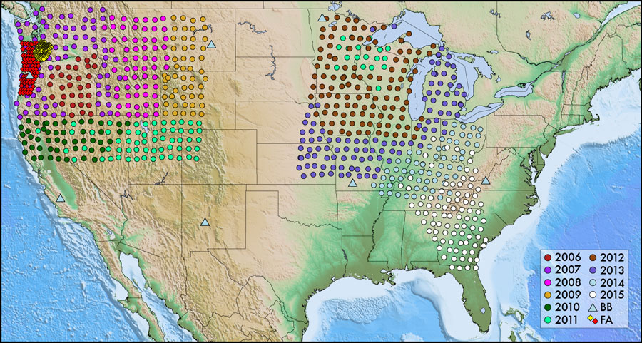 The map of MT-TA stations shows the location of the 85 sites being occupied in the southeastern US in 2015 (white circles). |
