
Teachers Learn Geophysics and Seismology Principles
Staff
from IRIS, UNAVCO and the EarthScope National Office conducted a professional
development workshop for teachers at the University of Nebraska-Lincoln in
early June. Twenty four teachers from Nebraska
and eastern Colorado
attended. During the workshop, entitled "Explore Central Great Plains Geology
and Geophysics through the EarthScope Program," the teachers improved their
foundation in geophysics, learned how EarthScope is investigating the Great Plains using geophysics, and participated in
activities and demonstrations that can be used in their classrooms.
 The National Science Foundation-sponsored workshop
featured a day and a half of activities and talks on using current geophysical
data to teach earth science. After an introduction to EarthScope and a
review of plate tectonics, teachers used a simple model of the earth to
construct a travel time curve. They then used the model to explore earth's
structure and the concept of seismic tomography. Later, the teachers had
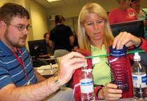
fun playing with the five-slinky model, acting as human seismic waves, and
building their own seismographs. Computer-based activities were a
prominent focus of the workshop, too. The
instructors guided teachers as they used the web-based EarthScope Voyager, Jr.
tool to understand the relationship between earthquakes, volcanoes and plate
tectonics; the Seismic Eruption software to "predict" the occurrence of
earthquakes; and online GPS time series plots to investigate plate motion. The teachers
also learned a new way to use seismograms to locate an earthquake's epicenter. Instead
of using interpreted seismograms from a textbook, they scrutinized actual
three-component seismograms to determine P- and S-wave arrival times and then
used their readings to find the earthquake's epicenter on an inflatable globe. The
workshop ended with an exploration of Episodic Tremor and Slip in the Pacific Northwest.
The National Science Foundation-sponsored workshop
featured a day and a half of activities and talks on using current geophysical
data to teach earth science. After an introduction to EarthScope and a
review of plate tectonics, teachers used a simple model of the earth to
construct a travel time curve. They then used the model to explore earth's
structure and the concept of seismic tomography. Later, the teachers had
fun playing with the five-slinky model, acting as human seismic waves, and
building their own seismographs. Computer-based activities were a
prominent focus of the workshop, too. The
instructors guided teachers as they used the web-based EarthScope Voyager, Jr.
tool to understand the relationship between earthquakes, volcanoes and plate
tectonics; the Seismic Eruption software to "predict" the occurrence of
earthquakes; and online GPS time series plots to investigate plate motion. The teachers
also learned a new way to use seismograms to locate an earthquake's epicenter. Instead
of using interpreted seismograms from a textbook, they scrutinized actual
three-component seismograms to determine P- and S-wave arrival times and then
used their readings to find the earthquake's epicenter on an inflatable globe. The
workshop ended with an exploration of Episodic Tremor and Slip in the Pacific Northwest.
The School
of Natural Resources at the University of Nebraska
-Lincoln hosted the teachers, and geologist Dr.
Matt Joeckel discussed Nebraska geology and
how geophysicists will use USArray data to understand the earthquake risk along
the Mid-Continent Rift under eastern Nebraska. On
the first night of the workshop, the University of Nebraska State Museum hosted
the teachers and instructors for a dinner surrounded by skeletons of ancient
elephants.
